Day 2 Convective Outlook
Issued: · Valid: –
Summary
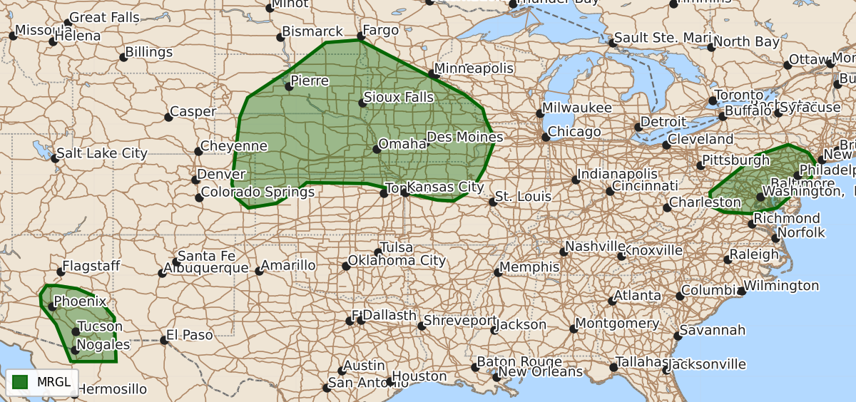
Marginally severe thunderstorms capable of producing large hail and damaging wind gusts are possible Saturday afternoon and evening across parts of the Central and Northern Plains, the Mid-Atlantic, and central or southeast Arizona.
Product Text
000 ACUS02 KWNS 071733 SWODY2 SPC AC 071731 Day 2 Convective Outlook NWS Storm Prediction Center Norman OK 1231 PM CDT Fri Aug 07 2026 Valid 081200Z - 091200Z ...THERE IS A MARGINAL RISK OF SEVERE THUNDERSTORMS WITHIN PARTS OF THE CENTRAL AND NORTHERN PLAINS INTO THE MID/UPPER MISSISSIPPI VALLEY...PARTS OF CENTRAL/SOUTHEAST ARIZONA...PARTS OF THE MID-ATLANTIC... ...SUMMARY... Thunderstorms with severe wind gusts will be possible Saturday afternoon and evening across parts of the central and northern Plains southeastward into the lower to mid Missouri Valley. Additional strong to severe storms are possible in the Mid-Atlantic and central/southeast Arizona. ...Central Plains into Upper Mississippi Valley... A complex forecast scenario continues to be evident on Saturday. Models continue to show a focused low-level jet into western Nebraska/South Dakota early Saturday morning. Some convection may be associated with this feature, though storm coverage is not clear. Depending on the evolution of that activity, some risk for severe winds and large hail is possible. Storm coverage will largely dictate how long early morning activity can persist into the afternoon as warming temperatures aloft are expected during the day. A strong enough cold pool would have to evolve in order to allow convection to propagate southeastward with the low-level jet decreasing into the late morning/early afternoon. Convective development during the afternoon is far from certain given the aforementioned capping that will exist. Forcing for ascent will be weak as well. Some guidance does show some thunderstorm development along the cold front in parts of the eastern Dakotas/western Minnesota. The Marginal has been expanded into these areas to account for this potential hail/wind threat. By late afternoon/early evening, an intensifying low-level jet will be focused within the Mid-Missouri Valley. Storm development will become more likely along the warm front as this occurs. However, the strongest activity may not form until around 06Z. This reduces confidence in how severe the activity will be, particularly in terms of severe wind. Again, the Marginal was expanded to the north/east to encompass the various model solutions. Large hail would be possible even with elevated storms given sufficient shear and steep mid-level lapse rates. A greater threat for severe wind gusts may still develop, but this is conditional on enough of a cold pool developing. Confidence remains rather low. ...Mid-Atlantic... A modest, low-amplitude shortwave trough will be favorably timed with afternoon heating. Widely scattered to scattered storms are possible ahead of this feature. Deep-layer shear will not be overly strong, but should be sufficient for strong/marginally severe cells and clusters. Storm coverage is not certain given the veered, deep-layer flow, but most model guidance suggests locally greater storm coverage from northern Virginia into eastern Pennsylvania and adjacent New Jersey. Wind damage will be the main concern. ...Arizona... Low 60s F dewpoints are forecast to remain within the lower desert areas. Strong heating should promote destabilization during the afternoon/early evening. Most CAM guidance suggests that one or more clusters will develop on the Mogollon Rim and move west/southwest. Severe wind gusts will be possible with this activity. ..Wendt.. 08/07/2026 $$