Day 1 Convective Outlook
Issued: · Valid: –
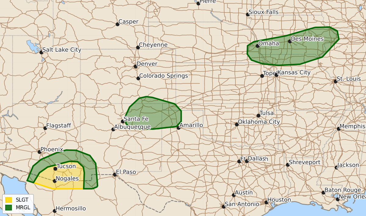
Summary
Severe thunderstorms capable of producing damaging wind gusts and hail are expected this evening across parts of southern Arizona, the southern Rockies, the southern High Plains, and the Upper Midwest.
Product Text
000 ACUS01 KWNS 050042 SWODY1 SPC AC 050040 Day 1 Convective Outlook NWS Storm Prediction Center Norman OK 0740 PM CDT Tue Aug 04 2026 Valid 050100Z - 051200Z ...THERE IS A SLIGHT RISK OF SEVERE THUNDERSTORMS ACROSS PARTS OF SOUTHERN ARIZONA... ...SUMMARY... Thunderstorms with severe wind gusts and hail will be possible this evening in parts of southern Arizona, the southern Rockies, the southern High Plains and the Upper Midwest. ...Southern Arizona... The latest surface analysis shows a sufficiently moist airmass over southern Arizona, where surface dewpoints are in the upper 50s to around 60 F. This is contributing to moderate instability over parts of southern Arizona, with the RAP suggesting that MLCAPE is in the 1000 to 2000 J/kg range. Thunderstorms have developed in the higher terrain of southwest New Mexico. These storms will move west-southwestward across southern Arizona this evening. In addition to the instability, surface temperature-dewpoint spreads across this airmass are large which is resulting in very steep low-level lapse rates. This will contribute to a potential for severe wind gusts this evening. ...Southern Rockies/Southern High Plains... Scattered thunderstorms are ongoing in the southern Rockies early this evening. These storms will move east-southeastward across southeastern Colorado and northeastern New Mexico this evening, where the RAP has SBCAPE around 1000 J/kg with moderate deep-layer shear and steep low to mid-level lapse rates. The environment will support an isolated potential for severe wind gusts and hail over the next few hours. ...Upper Midwest... An upper-level trough will move through the north-central U.S. this evening. Ahead of the trough, a moist and unstable airmass will be in place over the mid Missouri and mid to upper Mississippi Valleys. An axis of low-level moisture is analyzed from northeast Kansas into southeast Iowa, where surface dewpoints are in the 70s F. This is contributing to moderate instability with the RAP showing MLCAPE in the 2000 to 3500 J/kg range. Short-term model forecasts suggest that scattered thunderstorms will develop near the instability axis during the overnight period. The instability along with about 30 knots of 0-6 km shear will support an isolated wind-damage threat. ..Broyles.. 08/05/2026 $$