Day 1 Convective Outlook
Issued: · Valid: –
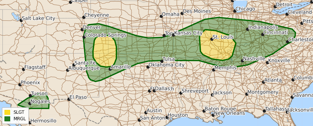
Summary
Severe thunderstorms capable of producing damaging wind gusts and hail are expected this evening across parts of the southern and central High Plains and the mid Mississippi Valley. Isolated severe wind gusts may also occur in parts of the Ohio Valley and far southeast Arizona.
Product Text
000 ACUS01 KWNS 110059 SWODY1 SPC AC 110058 Day 1 Convective Outlook NWS Storm Prediction Center Norman OK 0758 PM CDT Fri Jul 10 2026 Valid 110100Z - 111200Z ...THERE IS A SLIGHT RISK OF SEVERE THUNDERSTORMS ACROSS PARTS OF THE SOUTHERN AND CENTRAL HIGH PLAINS AND MID MISSISSIPPI VALLEY... ...SUMMARY... Thunderstorms with severe wind gusts and hail will be possible this evening across parts of the southern and central High Plains. Storms with severe wind gusts will also be possible in parts of the mid Mississippi Valley. A few severe gusts may also occur in parts of the Ohio Valley and in far southeast Arizona. ...Southern and Central High Plains... A mid-level shortwave trough is evident on water vapor imagery over the central Plains. At the surface, upslope flow is present over much of Kansas, eastern Colorado and southwestern Nebraska. Low-level convergence is maximized over eastern Colorado to the east of the higher terrain, where scattered thunderstorms are ongoing. Surface dewpoints over eastern Colorado are in the 50s F and the RAP shows moderate instability with very steep low to mid-level lapse rates. In addition, the WSR-88D VWP at Pueblo has 0-6 km near 45 knots, and veering winds with height in the low to mid-levels. This environment will continue to support severe storm development this evening. Supercells and short muticell line segments will be capable of severe wind gusts and hail. The severe threat will gradually move eastward into western Kansas, and the Oklahoma/Texas Panhandles later this evening. ...Mid Mississippi and Ohio Valleys... A very moist airmass is currently located over the mid Mississippi Valley, where surface dewpoints range from the mid 70s to mid 80s F. Along the axis of highest surface dewpoints, the RAP has a pocket of strong instability over southeast Missouri with MLCAPE in the 3000 to 4000 J/kg range. Low-level convergence is maximized across parts of eastern Missouri, where thunderstorms are ongoing. The WSR-88D VWP at St. Louis has 0-6 km shear around 25 knots with unidirectional west-southwesterly flow. This, along with the instability and steep low-level lapse rates, could support a potential for severe wind gusts with the stronger cores this evening...see MCD 1582. Further east into parts of the Ohio Valley, surface dewpoints are in the 70s F. The RAP shows an axis of moderate instability with MLCAPE in the 1500 to 2000 J/kg range, which is coincident with a zone of low-level convergence. Near this zone, scattered thunderstorms are ongoing from north-central Illinois into central Indiana and southern Ohio. The instability and steep low-level lapse rates may support a threat for isolated severe gusts over the next couple of hours. ...Far Southeast Arizona... Scattered thunderstorms are currently ongoing in far southeast Arizona along an axis of low-level convergence. Near this axis, the RAP has SBCAPE near 1000 J/kg with 0-3 km lapse rates exceeding 9 C/km. This environment will support a potential for isolated severe gusts early this evening. ..Broyles.. 07/11/2026 $$