Day 1 Convective Outlook
This product has been superseded. View the updated product →
Issued: · Valid: –
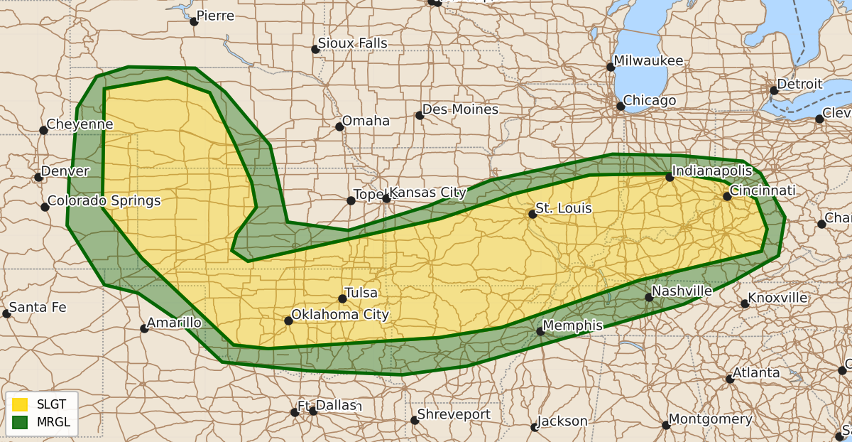
Summary
Scattered severe thunderstorms capable of large hail, damaging winds, and tornadoes are expected across the central High Plains through the Mississippi and Ohio Valleys from this afternoon into tonight. Parts of Missouri, Illinois, Indiana, and Kentucky face an increased risk of strong tornadoes and intense wind gusts during the afternoon and evening.
Product Text
000 ACUS01 KWNS 211612 SWODY1 SPC AC 211610 Day 1 Convective Outlook NWS Storm Prediction Center Norman OK 1110 AM CDT Sun Jun 21 2026 Valid 211630Z - 221200Z ...THERE IS A SLIGHT RISK OF SEVERE THUNDERSTORMS FROM THE CENTRAL HIGH PLAINS INTO THE MID MISSISSIPPI AND LOWER OHIO VALLEYS... ...SUMMARY... Scattered severe thunderstorms should occur from the central High Plains into the mid Mississippi and lower Ohio Valleys, mainly this afternoon into tonight. Large to very large hail, severe/damaging winds (some 75+ mph), and tornadoes will all be possible. Some potential for strong tornadoes may develop across parts of Missouri, Illinois, and Indiana during the afternoon and evening. ...MO/IL/IN/KY... A long-lived band of thunderstorms currently extends from east-central MO into southwest MO/northeast OK. This activity is tracking into a region of increasingly warm/moist air where dewpoints are rising to near 70F and breaks in the clouds are contributing to moderate CAPE values. All CAM guidance suggests that storms along the line will intensify this afternoon and track eastward across southern IL/southern IN and northern KY. Low-level shear is quite strong, but somewhat veered. This increases uncertainty of storm mode between discrete supercells or bowing structures. It appears there will be a period of risk early in the event for tornadic supercells, followed by multiple linear storm segments capable of damaging wind gusts. Storms may remain severe as far east as southern OH and eastern KY overnight. Refer to MD #1228 for further short-term details. ...MO/KS/OK/AR... In the wake of the aforementioned convection, an outflow boundary extends southwestward into central OK. Rapid clearing is occurring north of the boundary, where residual moisture and steep lapse rates will quickly destabilize the area. Scattered thunderstorms are expected to form by late afternoon in this zone and track slowly southeastward. Sufficient deep-layer shear and high CAPE will promote the risk of a few supercells capable of large hail and damaging winds. A tornado or two might also occur. ...NE/CO/KS... Low clouds are eroding across the NE Panhandle southward into eastern CO/western KS, where rapid afternoon destabilization should occur. A weak shortwave trough over eastern WY will rotate into the region this afternoon, helping to initiate scattered thunderstorms. Supercells capable of very large hail appear possible, tracking southeastward across the risk area through mid-evening. ..Hart/Moore.. 06/21/2026 $$