Day 1 Convective Outlook
Issued: · Valid: –
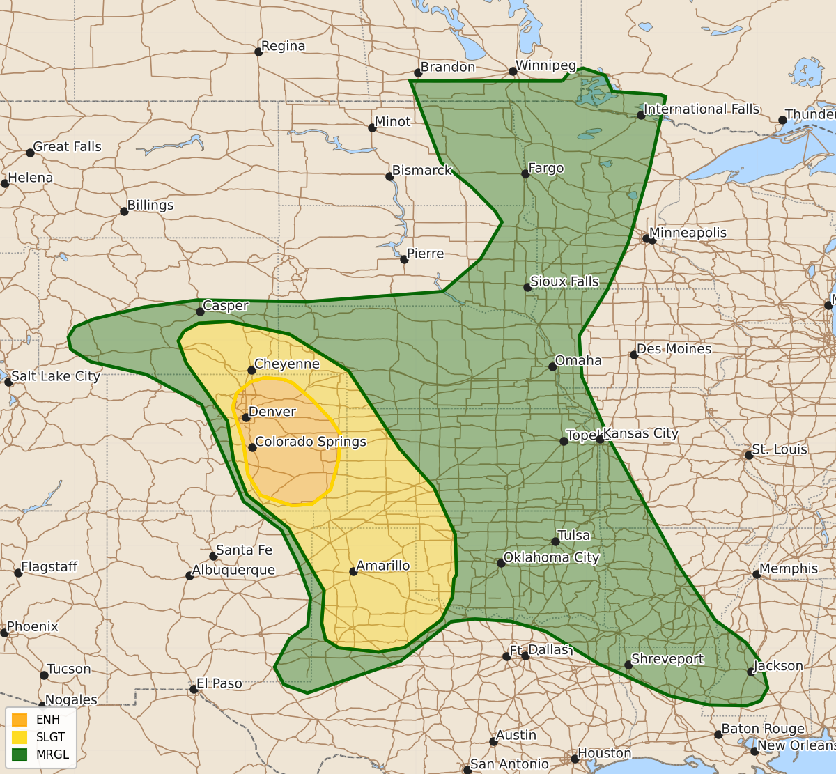
Summary
Severe thunderstorms capable of producing very large hail, damaging wind gusts, and isolated tornadoes are expected across eastern Colorado and the central High Plains into the southern Plains tonight. Additional risks of damaging gusts and hail will affect the Arklatex region later tonight and into early tomorrow morning.
Product Text
000 ACUS01 KWNS 240059 SWODY1 SPC AC 240057 Day 1 Convective Outlook NWS Storm Prediction Center Norman OK 0757 PM CDT Tue Jun 23 2026 Valid 240100Z - 241200Z ...THERE IS AN ENHANCED RISK OF SEVERE THUNDERSTORMS ACROSS EASTERN COLORADO... ...SUMMARY... Severe thunderstorms capable of producing 2+ inch diameter hail, 75+ mph gusts, and isolated tornadoes are expected from the central High Plains into parts of the southern Plains tonight. ...Central High Plains into the southern Plains... Three primary areas of thunderstorms currently exist across the region: southeast WY, east-central CO, and the TX South Plains vicinity. The northernmost cluster across southeast WY has struggled to maintain intensity, likely due to modest convective inhibition remaining in place. Even so, given the favorable low-level moisture downstream, there is still some chance for intensification. Environmental conditions support the potential for large hail up to 2 inches in diameter and isolated severe gusts with any storms that can mature into the more favorable buoyancy downstream. Large to very large hail remains possible for at least the next several hours with the discrete, splitting storms across east-central CO. Strong outflow (greater than 50 kt) remains possible as well. Additional storm development appears likely in this area amid persistent low-level moisture advection and a strengthening low-level jet. These additional storms will have similar hazards, with large to very large hail as the primary risk. Hail from 2" to 3.5" in diameter is possible. Strong gusts could become more likely with time if cold pool amalgamation results in a forward-propagating cluster. Several supercells continue across the TX South Plains. A strengthening low-level jet and steep mid-level lapse rates will help maintain the risk for large to very large hail and severe gusts with these storms for at least the next several hours. ...Arklatex and vicinity... Ongoing cluster moving through the Arklatex will likely continue southeastward tonight, with an attendant risk for isolated damaging gusts. Some hail is possible as well, particularly late tonight/early tomorrow with any warm-air advection storms that develop in the wake of this cluster. ..Mosier.. 06/24/2026 $$