Day 2 Convective Outlook
Issued: · Valid: –
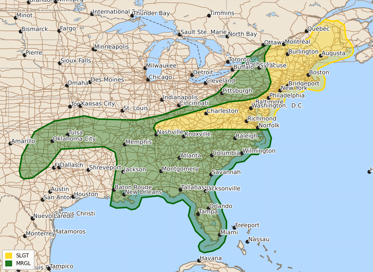
Summary
Scattered severe thunderstorms capable of producing damaging wind gusts, large hail, and an isolated tornado are expected from Kentucky through the Mid-Atlantic and parts of New England on Wednesday and Thursday. Severe storms may also occur across the Southern Plains, the Ozarks, and the Southeast through Thursday evening.
Product Text
000 ACUS02 KWNS 171725 SWODY2 SPC AC 171723 Day 2 Convective Outlook NWS Storm Prediction Center Norman OK 1223 PM CDT Wed Jun 17 2026 Valid 181200Z - 191200Z ...THERE IS A SLIGHT RISK OF SEVERE THUNDERSTORMS FROM CENTRAL KENTUCKY INTO THE MID-ATLANTIC AND PORTIONS OF NEW ENGLAND... ...SUMMARY... Isolated to scattered severe thunderstorms will be possible from Kentucky to the Mid-Atlantic, and across parts of the Northeast. Damaging wind gusts will be the main hazard with this activity. ...Synopsis... A potent upper trough and associated mid-level jet streak will move into the northern Mid-Atlantic/New England Thursday morning. A deep surface low moving through southern Ontario/Quebec will drive a surface cold front through the regions. This front will extend southwestward into the Ohio Valley/southern Appalachians and parts of the central/southern Plains. The remnants of what is now Tropical Storm Arthur will continue through parts of the Southeast. ...New England/Mid-Atlantic... Convection will likely be ongoing ahead of the upper trough during the morning, particularly from eastern New York into New England. While this activity is likely to inhibit afternoon destabilization, strong wind fields will still promote some risk for damaging winds and perhaps a brief tornado. The strongest activity will develop by early afternoon along the cold front and progress eastward. Bowing segments and marginal supercell structures will be possible. The strong low-level jet will be shifting eastward during the day, but portions of New England will still have strong 850 mb winds during the early/mid afternoon. If sufficient heating occurs, this is where the tornado risk will be marginally greater. ...Kentucky/West Virginia/Virginia... Stronger instability is expected south of the surface front on account of richer low-level moisture. Scattered storms are expected to form along the front by mid afternoon. Though the low-level jet will weaken much quicker in these areas, deep-layer shear near the front will remain sufficient for organized cells and linear segments. These storms will move eastward through the afternoon and pose a risk of damaging wind gusts. ...Southern Plains into Ozarks... Elevated convection may be ongoing early in the period near and north of the cold front in southern Kansas/southwest Missouri. These storms could produce large hail. With time, the front will sag southward. Strong heating of a 70+ F dewpoint airmass will potentially promote afternoon thunderstorms capable of marginally severe hail and isolated severe gusts. During the evening, additional thunderstorms may develop as a modest increase in the low-level jet occurs. Some guidance suggests this activity may cluster into a small MCS within western Oklahoma/northwest Texas. Where and if this occurs is not certain. Some risk for severe gusts could extent into the evening if this occurs. ...Southeast... The remnants of Tropical Storm Arthur will move through a very moist (70+ F dewpoints) airmass. Local shear magnitudes will be modestly enhanced by the remnant circulation. Scattered convection will be capable of wind damage and perhaps a tornado or two. Portions of Georgia may see greater surface heating ahead of the circulation. A few stronger storms are possible here. Even so, poor mid-level lapse rates and deep-layer shear (especially away from the circulation center) will limit the overall severe threat. ..Wendt.. 06/17/2026 $$