Day 1 Convective Outlook
This product has been superseded. View the updated product →
Issued: · Valid: –
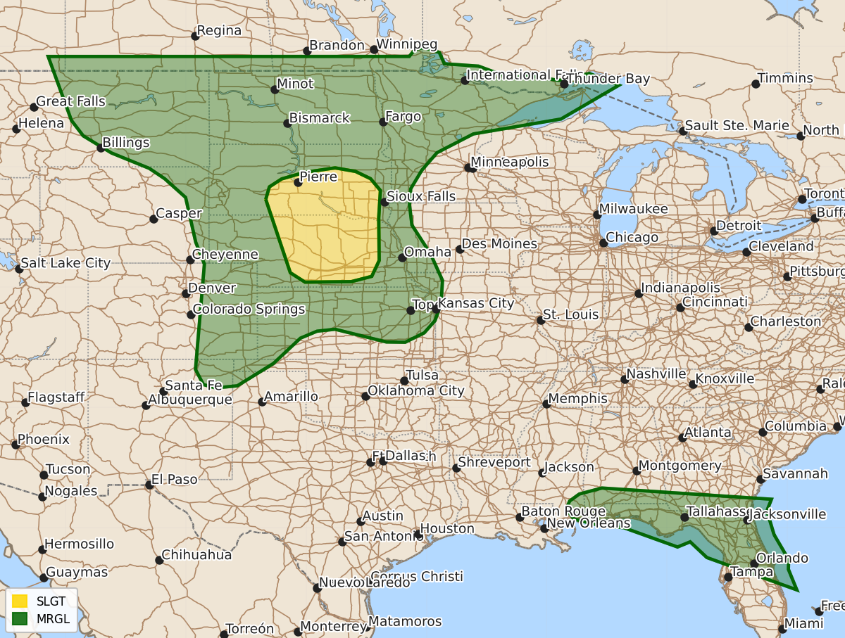
Summary
Severe thunderstorms capable of producing damaging wind gusts and large hail are expected this afternoon and evening across parts of the central and northern Plains, particularly Nebraska and South Dakota, as well as parts of the Southeast. Isolated severe wind gusts may also occur in the Southeast through late afternoon and early evening.
Product Text
000 ACUS01 KWNS 301250 SWODY1 SPC AC 301249 Day 1 Convective Outlook NWS Storm Prediction Center Norman OK 0749 AM CDT Thu Jul 30 2026 Valid 301300Z - 311200Z ...THERE IS A SLIGHT RISK OF SEVERE THUNDERSTORMS ACROSS THE CENTRAL PLAINS... ...SUMMARY... Thunderstorms with severe wind gusts and isolated large hail will be possible this afternoon and evening across parts of the central and northern Plains, but especially across parts of Nebraska and South Dakota. Isolated severe wind gusts may also occur across parts of the Southeast. ...Central and Northern Plains including Nebraska/South Dakota... An amplifying shortwave trough evident in water vapor imagery over Wyoming this morning will continue east and then a bit southeastward through tonight toward the middle Missouri Valley and Upper Midwest. A cold front will become more southeastward-progressive later today and tonight, intercepting a moisture-rich air mass across Kansas into Nebraska/South Dakota. Early day scattered precipitation/cloud cover will tend to abate and/or shift away from the region later today, allowing for ample insolation near a surface trough and ahead of the front. Mid-tropospheric winds will be weak, but a few initial supercells could occur in vicinity of south-central South Dakota into central Nebraska amidst somewhat stronger effective shear. Some severe hail will be possible early in the developmental cycle, but damaging winds should be an increasing and more common concern with the expectation that storms will cluster, grow upscale, and progress southeastward this evening, aided by an increasingly strong southwesterly low-level jet. Further west into parts of the High Plains, pockets of moderate instability may develop in parts of eastern Colorado, western Kansas and eastern Montana. Although large-scale ascent will be weak in these areas, topographic forcing will aid convective initiation. During the mid/late afternoon into evening, isolated to scattered storms will move east-southeastward into the lower elevations, including the possibility of storms spreading from southern Saskatchewan into northeast Montana, where a somewhat more severe-favorable environment will exist. Localized strong to severe wind gusts and hail will be possible regionally. ...Southeast/Florida... A very moist air mass will persist regionally to the south of a generally west/east-oriented front. Scattered thunderstorms are already ongoing this morning particularly across northern Florida and nearby offshore waters, with additional storm development expected to the north near and just south of the front where stronger insolation/destabilization is expected. Some of the stronger storms that develop and mature will be capable of isolated damaging wind gusts through late afternoon/early evening. ..Guyer/Wendt.. 07/30/2026 $$