Day 4-8 Convective Outlook
Issued: · Valid: –
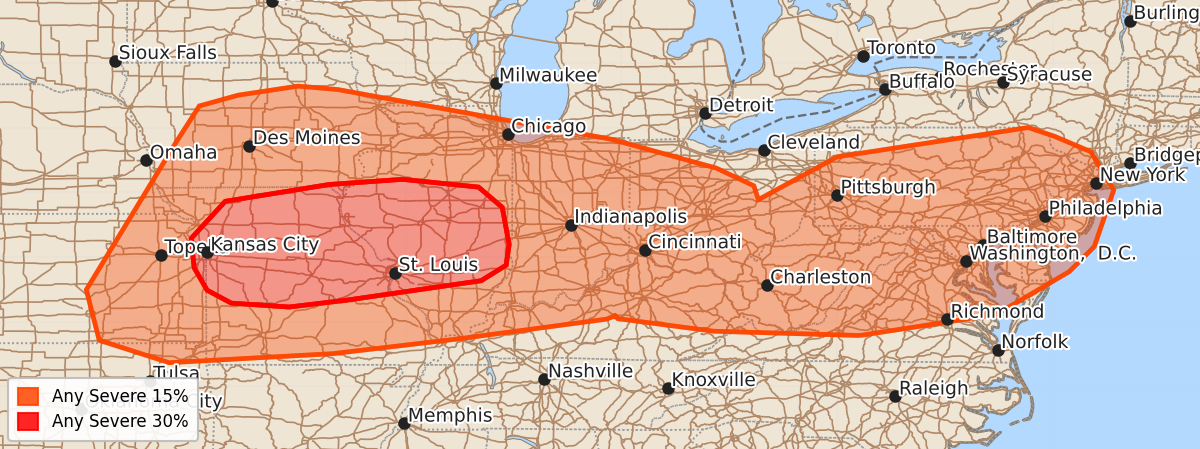
Summary
Significant severe storms are expected across portions of the Lower Mississippi Valley and Mid-Mississippi Valley on Wednesday, with the risk of intense supercells and bowing storm systems. Severe weather potential continues through Thursday across parts of the Ohio Valley and Mid-Atlantic, primarily involving damaging winds.
Product Text
000 ACUS48 KWNS 140746 SWOD48 SPC AC 140744 Day 4-8 Convective Outlook NWS Storm Prediction Center Norman OK 0244 AM CDT Sun Jun 14 2026 Valid 171200Z - 221200Z ...DISCUSSION... ...Day 4/Wednesday -- Mid-MS and Ohio Valley vicinity... An upper shortwave trough is forecast to deepen as it moves across the Upper Midwest and Great Lakes on Wednesday. As this occurs, an intense jet streak (especially by June standards) is forecast to overspread portions of the Midwest. The ECMWF and GFS suite of forecast guidance still is indicating a 500 mb jet streak greater than 80 kt overspreading the region by evening. Furthermore, low and midlevel flow will also be quite strong, with a daytime 850 mb low-level jet around 40-50 kt by mid/late afternoon. At the surface, low pressure will deepen and move across the Upper MS Valley and Lower MI through the period. A warm front is forecast to move rapidly northward across IL and portions of the OH Valley through 00z. Meanwhile, a trailing cold front will develop eastward across the region through the period. The warm sector will be characterized by dewpoints in the mid 60s to low 70s, and areas of strong destabilization are expected. While details concerning convective evolution remain uncertain, the overall environment will support supercells with upscale development into a bowing MCS possible by evening as the low-level jet continues to increase and spread east/northeast across the region. All severe hazards appear likely, with the greatest risk likely emerging across portions of the Lower MO/Mid-MS Valley where significant severe storms are expected. Some severe risk will likely persist into the nighttime hours across parts of the Ohio Valley given intense deep-layer flow and sufficient instability. Some details will likely change in subsequent outlooks as the track of the surface low and orientation of the mid/upper level jet streak atop the develop surface warm sector become better resolved closer to the event. The risk areas may shift some as these details become clearer. ...Day 5/Thursday -- Ohio Valley to Mid-Atlantic... An upper shortwave trough will pivot across the Lower Great Lakes/Northeast on Thursday, with a strong southwesterly jet streak forecast to overspread parts of the Ohio Valley into New England. The jet streak may tend to become increasing displaced from better low-level moisture/thermodynamic with time and eastward extent through the period. Nevertheless, a moist and unstable airmass is expected ahead of an eastward-advancing cold front and a severe risk should unfold across parts of the Ohio Valley to the Mid-Atlantic. Northward extent of the severe risk is uncertain as early period convection and widespread rainfall may hinder destabilization. The best overlap of favorable vertical shear and instability is delineated by the 15 percent probabilities from OH/KY into the Mid-Atlantic, where damaging wind potential is likely to be the main concern. ...Days 6-8/Friday-Sunday... Large spread among medium range guidance during the end of the forecast period leads to low predictability. The surface front from Day 4/5 will likely stall across the southern U.S. and periods of heavy rain will be possible across the Southeast. Late in the period, some signal for moisture return and a deepening lee low over the Plains could bring some increasing severe risk, but details remain uncertain. ..Leitman.. 06/14/2026