Day 1 Convective Outlook
Issued: · Valid: –
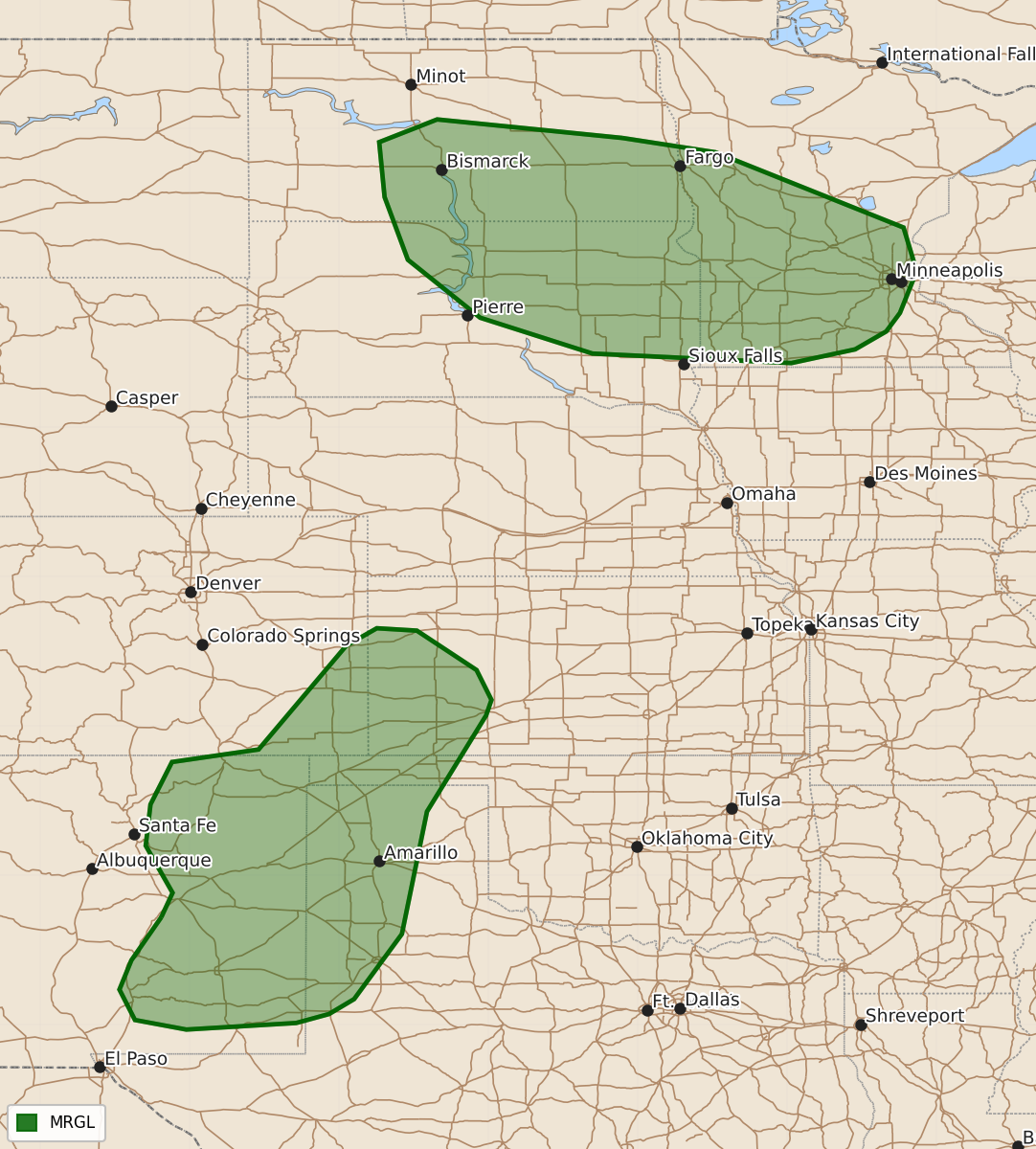
Summary
Isolated large hail and severe thunderstorm winds are expected across the southern High Plains and the Dakotas/Upper Midwest this afternoon and evening. The Gulf Coast and Coastal Southeast may also experience thunderstorms capable of producing heavy rain and occasional damaging wind gusts.
Product Text
000 ACUS01 KWNS 151612 SWODY1 SPC AC 151611 Day 1 Convective Outlook NWS Storm Prediction Center Norman OK 1111 AM CDT Mon Jun 15 2026 Valid 151630Z - 161200Z ...THERE IS A MARGINAL RISK OF SEVERE THUNDERSTORMS ACROSS THE SOUTHERN HIGH PLAINS AND UPPER MIDWEST... ...SUMMARY... Isolated large hail and severe thunderstorm winds may occur across the southern High Plains and Dakotas/Upper Midwest this afternoon and evening. ...Southern High Plains... Northwesterly flow aloft will support a sharpening lee trough across the southern High Plains today, with lee cyclogenesis yielding a surface low over southeast CO by the late afternoon. Mass response to the deepening lee trough and developing surface low will result in moist low-level southeasterly/southerly flow across much of the southern High Plains. This moistening will help offset mixing via diurnal heating, keeping dewpoints in the 50s through the afternoon. Steep mid-level lapse rates will be in place as well, with the combination of low-level moisture and steep mid-level lapse rates supporting airmass destabilization and moderate buoyancy by this afternoon. Thunderstorm development is initially expected over the high terrain of south-central CO and central NM during the afternoon. Moderate deep-layer westerly flow will take these storms into the lower elevations of the southern High Plains during the late afternoon and evening. Moderate buoyancy combined with 30 to 40 kt of effective shear will support the potential for a few supercells and sustained multicells, with potential consolidation into small organizing southeastward-moving clusters. Hail is possible early in the convective cycle, with a trend towards more damaging gusts within any forward-propagating clusters during the late afternoon and evening. ...Dakotas/Minnesota... Morning satellite imagery shows a well-defined shortwave trough dropping southeastward into the northern Plains within the western periphery of a broad upper trough that extends over much of the central and eastern CONUS. Surface moisture will be limited ahead of this wave, but low to mid-level moisture attendant to the shortwave and cold temperatures aloft will still support modest buoyancy across the region this afternoon. This buoyancy coupled with ascent from the shortwave will result in isolated to widely scattered high-based thunderstorms. Additionally, strengthening west-northwesterly flow attendant to the shortwave could yield some strong/locally severe wind gusts this afternoon through around sunset. ...Gulf Coast/Coastal Southeast... A very moist airmass is in place in the vicinity of a weak frontal zone that extends from the TX Coast northeastward through the central Gulf Coast and southern GA. Numerous to widespread showers and thunderstorms are anticipated across much of this region. The airmass is weakly sheared, favoring a slow-moving, disorganized storm evolution with heavy rain as the primary risk (as noted in the Day 1 WPC Excessive Rainfall Outlook). However, a few damaging gusts from water-loaded downbursts are still possible. Overall coverage is expected to remain less than 5%. ..Mosier/Chalmers.. 06/15/2026 $$