Day 3 Convective Outlook
Issued: · Valid: –
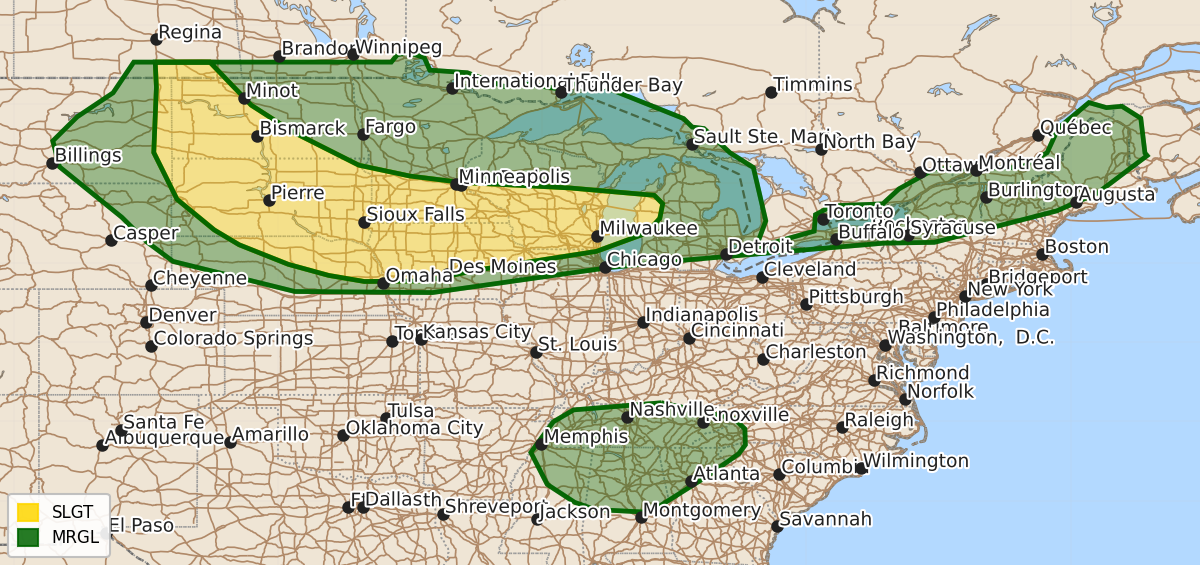
Summary
Strong to severe thunderstorms are expected on Thursday across the northern Plains, Midwest, and Great Lakes, with additional isolated severe storms possible in the Tennessee Valley, Southeast, and Northeast. These storms may bring damaging winds, hail, and microbursts.
Product Text
000 ACUS03 KWNS 301913 SWODY3 SPC AC 301911 Day 3 Convective Outlook NWS Storm Prediction Center Norman OK 0211 PM CDT Tue Jun 30 2026 Valid 021200Z - 031200Z ...THERE IS A SLIGHT RISK OF SEVERE THUNDERSTORMS ACROSS PORTIONS OF THE NORTHERN PLAINS TO THE GREAT LAKES... ...SUMMARY... Strong to severe storms will be possible from the northern Plains into the Midwest and Great Lakes regions on Thursday. Isolated strong to severe storms may also occur in the Tennessee Valley/Southeast as well as parts of the Northeast. ...Northern High Plains to the Upper Midwest... Upper ridging will build over the northern Plains on Thursday, though temperatures aloft will remain fairly cool at around -12 to -10 C at 500 mb. A broad belt of enhanced west/southwesterly mid/upper-level flow will overspread the region, and a southerly low-level jet is forecast to intensify across the central into northern Plains overnight. At the surface, a quasi-stationary boundary will arc from northern North Dakota into central MN/WI during the afternoon. Meanwhile, a surface trough will extend southward along the High Plains. South/southeasterly low-level flow will maintain a very moist airmass across parts of the central Plains into the Upper Midwest, while transporting low 60s dewpoints northwest to near the ND/SD/MT/WY border. A broad swath of moderate to strong instability will materialize across the warm sector buffered by these two surface boundaries. Convection may be ongoing where from the Mid-MO Valley to Upper Midwest Thursday morning, though this is uncertain. Additional storms are expected during the afternoon along the surface boundaries across the northern High Plains southeastward into MN/IA/WI. Forecast soundings suggest supercell will be possible, with an accompanying all-hazards risk possible, at least initially. With time, convection in the High Plains should grow upscale and track southeast along the surface boundary and in the vicinity of the terminus of the increasing low-level jet. This activity will pose a risk of damaging wind swaths. Additional clustering/MCS development is possible near the surface boundary across MN/WI and perhaps into Lower MI during the evening/overnight. ...TN Valley Vicinity... Another modest midlevel shortwave impulse will likely migrate through easterly flow on the southern periphery of the upper ridge over the eastern U.S. A very moist and strongly unstable airmass will once again support a wet microburst risk, with some potential for sufficient clustering to result in forward propagating convection. Isolated to widely scattered damaging wind gusts are expected. ...Northeast... A weak cold front will approach the region Thursday night as a surface low over Quebec lifts northeast. Ahead of this feature a very moist, hot, and unstable airmass will be in place. Minor height falls throughout the day and increasing westerly flow aloft will support at least isolated thunderstorm development. Strong/locally damaging gusts and hail will be possible with the strongest storms. ..Leitman.. 06/30/2026 $$