Mesoscale Discussion 2166
Issued: · Valid: –
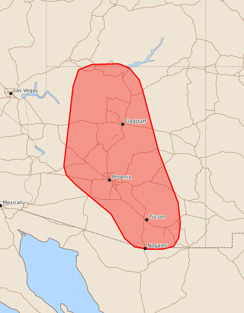
Summary
Increasingly widespread thunderstorms across central and northern Arizona may produce severe downburst winds of 55 to 70 mph through the late afternoon.
Product Text
000 ACUS11 KWNS 291757 SWOMCD SPC MCD 291756 AZZ000-UTZ000-292030- Mesoscale Discussion 2166 NWS Storm Prediction Center Norman OK 1256 PM CDT Sat Aug 29 2026 Areas affected...Arizona Concerning...Severe potential...Watch unlikely Valid 291756Z - 292030Z Probability of Watch Issuance...5 percent SUMMARY...Thunderstorms will increase in coverage through the late afternoon hours across the central third of Arizona. The potential for severe downburst winds should increase in tandem with convective coverage. However, the severe wind threat should remain sufficiently transient and isolated to preclude watch issuance. DISCUSSION...Latest GOES imagery over the past 30-60 minutes has shown a steady increase in coverage and depth of cumulus along with increasing lightning counts across central to northern AZ. Temperatures across the region have been running on the warm side of the guidance envelope this morning and early afternoon, and this stronger heating is likely the primary contributing factor for the somewhat early onset (compared to most 12z solutions) of surface-based convective initiation as inhibition is quickly eroded via heating/mixing. Attendant to the strong heating, low-level lapse rates are rapidly steepening to 8 to 9 C/km based on RAP mesoanalysis estimates and 30-40 F dewpoint depressions observed across the region. Consequently, low-level thermodynamic profiles are becoming increasingly favorable for accelerating downdrafts near the surface. Regional VWPs are sampling very weak (less than 15 knot) winds within the lowest 2-3 km and only modest flow aloft (generally 20-25 knots). This should promote poorly organized and outflow-dominant convection with perhaps some tendency for clustering through the late afternoon. While marginal/sub-severe hail is possible, the primary hazard should be strong to severe outflow winds with the deeper convective cores/more intense downbursts. Based on recent RRFS solutions (which appear to be capturing low-level thermodynamic conditions the best), embedded swaths of outflow winds as strong as 60-70 mph are possible. Based on latest GOES/reflectivity imagery, central to north-central AZ should see the severe wind threat increase through the next few hours as convection continues to deepen. Further southeast, very weak low-level convergence is noted in the surface wind field, and a lack of cumulus suggests deep convection is not imminent. However, time-lagged CAM consensus is that convection should emerge between 19-21 UTC. ..Moore/Mosier.. 08/29/2026 ...Please see www.spc.noaa.gov for graphic product... ATTN...WFO...TWC...FGZ...SLC...PSR...VEF... LAT...LON 33881349 36381320 36901303 37071261 37091177 36961144 36591113 36221101 34341052 32740991 32090984 31640989 31371005 31281039 31281087 31351127 31611158 32381201 33301312 33601341 33881349 MOST PROBABLE PEAK WIND GUST...55-70 MPH