Day 2 Convective Outlook
Issued: · Valid: –
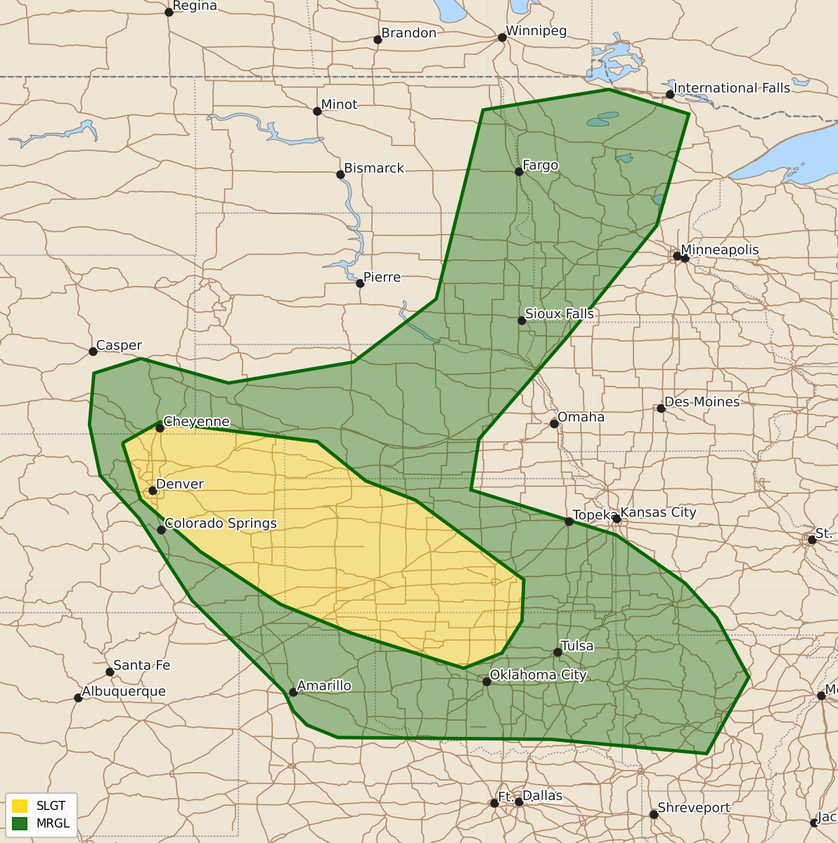
Summary
Scattered severe thunderstorms are expected Tuesday across the central High Plains into the Upper Mississippi Valley, with a risk of large hail and damaging winds. Portions of eastern Colorado, western Kansas, and northern Oklahoma are particularly at risk for these severe weather threats throughout the day and evening.
Product Text
000 ACUS02 KWNS 220559 SWODY2 SPC AC 220558 Day 2 Convective Outlook NWS Storm Prediction Center Norman OK 1258 AM CDT Mon Jun 22 2026 Valid 231200Z - 241200Z ...THERE IS A SLIGHT RISK OF SEVERE THUNDERSTORMS ACROSS PORTIONS OF EASTERN COLORADO INTO WESTERN KANSAS AND NORTHERN OKLAHOMA.... ...SUMMARY... Scattered severe storms are expected across the central High Plains on Tuesday with isolated severe storms possible into the Upper Mississippi Valley. Large to very large hail and damaging wind gusts will be the primary threats. ...Synopsis... An upper low initially over southern Canada will shift into the northern Plains with a belt of 40-50+ kt mid-level flow forecast across the northern and central Plains into the upper Midwest. In the low levels, an area of low pressure is forecast to develop from the northern Plains into upper MS Valley with a trailing boundary extending southwest into the central High Plains. Elsewhere, a cold front will move off the Mid-Atlantic Coast with the trailing extension of the boundary moving into the Southeast. ...Central High Plains into the Central/Southern Plains... As mid-level flow strengthens across the Rockies, a lee cyclone will develop across eastern Colorado and result in strengthening upslope flow. Moderate to strong instability is expected within this zone. This instability, combined with nearly 50 knots of mid-level flow, will result in a supercell environment. Large to very large hail will be the primary threat from this activity. Eventual upscale growth into a cluster is expected, and a potential bowing MCS across western Kansas and potentially northern Oklahoma should result in an increasing severe wind threat during the evening and into the early overnight hours. ...Portions of the northern Plains into the Upper Midwest... Some elevated storms may be ongoing at the beginning of the period from northern Nebraska into southeast South Dakota on the nose of a modest low-level jet. These storms could pose some large hail threat. Additional storms may develop along the front during the afternoon. Strong mid-level flow will result in adequate shear for storm organization, but instability may be the primary limiting factor. Extensive cloud cover may limit heating, but at least some pockets of greater destabilization are possible. Within these areas, a threat for isolated large hail may exist. ...Southeast... A few strong storms capable of gusty winds appear possible Tuesday afternoon along and ahead of the synoptic front from the Gulf Coast to the eastern Carolinas. Poor lapse rates will be the primary limiting factor for damaging wind gusts. However, as the event gets closer and details regarding instability and frontal position become more clear, wind probabilities may be warranted. ..Bentley.. 06/22/2026 $$