Day 1 Convective Outlook
Issued: · Valid: –
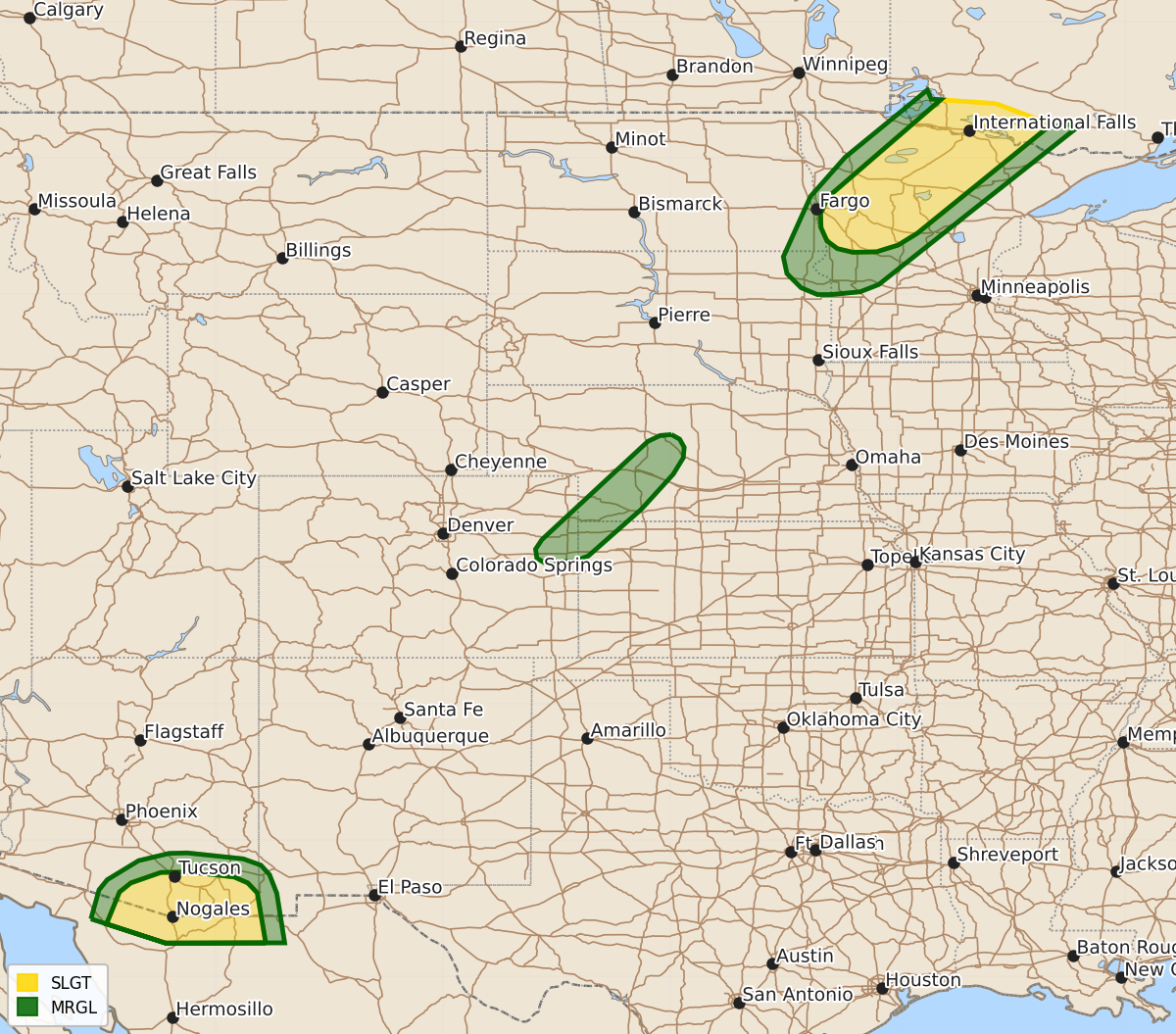
Summary
Severe thunderstorms capable of producing damaging wind gusts and isolated large hail are expected across western and northern Minnesota this evening. Severe wind gusts are also possible in southeastern Arizona over the next few hours.
Product Text
000 ACUS01 KWNS 040101 SWODY1 SPC AC 040059 Day 1 Convective Outlook NWS Storm Prediction Center Norman OK 0759 PM CDT Mon Aug 03 2026 Valid 040100Z - 041200Z ...THERE IS A SLIGHT RISK OF SEVERE THUNDERSTORMS ACROSS PARTS OF WESTERN AND NORTHERN MINNESOTA... ...SUMMARY... Thunderstorms with severe wind gusts and isolated large hail will be possible this evening over parts of western and northern Minnesota. Severe wind gusts are also expected in parts of southeastern Arizona. ...Western and Northern Minnesota... On water vapor imagery, west-southwesterly mid-level flow is present over much of the north-central U.S., with a subtle shortwave trough evident over northern Minnesota. At the surface, a cold front is located over northwestern Minnesota. Surface dewpoints ahead of the front range from 65 to 70 F, and the RAP has MLCAPE in the 1500 to 2500 J/kg range. This is supporting scattered thunderstorm development across northwest Minnesota. In addition, a 60 to 70 knot mid-level jet is moving over the top of this moist and unstable airmass, and is creating moderate deep-layer shear. This will be favorable for organized storms capable of producing severe wind gusts and isolated large hail. The severe threat will be maximized with supercells that develop. ...Central High Plains... The latest surface analysis shows a cold front located from northeast Colorado northeastward into central Nebraska, along which low-level convergence is maximized. This is supporting scattered thunderstorm development. Just ahead of the front, an axis of moderate instability is analyzed by the RAP over central and southwest Nebraska, where MLCAPE is estimated to be from 1000 to 2000 J/kg. In addition, low to mid-level lapse rates are steep according to the RAP, with 0-3 km lapse rates exceeding 8 C/km over parts of southwest Nebraska. This environment will contribute to strong downdrafts capable of producing isolated severe gusts. ...Southeast Arizona... A moderately unstable airmass is currently located across southeast Arizona, where the RAP has MLCAPE in the 1000 to 2000 J/kg range. Thunderstorms are ongoing along the northern edge of the stronger instability. These storms will move west-southwestward across the remainder of southeastern Arizona over the next few hours. Steep low to mid-level lapse rates will contribute to a potential for severe wind gusts. ..Broyles.. 08/04/2026 $$