Day 3 Convective Outlook
Issued: · Valid: –
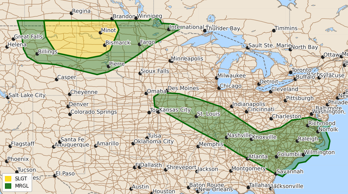
Summary
Severe thunderstorms are likely across eastern Montana and western North Dakota on Saturday, with more isolated strong storms possible from the Mid-Mississippi Valley to Virginia and the Carolinas during the afternoon and evening. These storms may bring damaging winds, large hail, and potentially tornadoes.
Product Text
000 ACUS03 KWNS 250717 SWODY3 SPC AC 250715 Day 3 Convective Outlook NWS Storm Prediction Center Norman OK 0215 AM CDT Thu Jun 25 2026 Valid 271200Z - 281200Z ...THERE IS A SLIGHT RISK OF SEVERE THUNDERSTORMS ACROSS PORTIONS OF THE NORTHERN PLAINS.... ...SUMMARY... Severe storms are likely across portions of eastern Montana and western North Dakota on Saturday. More isolated strong to severe storms are possible from the Mid-Mississippi Valley to Virginia and the Carolinas. ...Synopsis... On Saturday, the leading edge of a larger mid-level shortwave trough will eject across the northern Plains. A surface lee cyclone will develop in this vicinity. Farther east, a weak surface low is forecast to move from the Ohio Valley to the East Coast, weakening through the period. ...Northern Plains... Low-level southerly flow will strengthen through the day Saturday within the warm sector of a lee cyclone across the Plains. This will lead to destabilization and moderate to strong instability by mid-afternoon Saturday. Storms will initially form across parts of central and eastern Montana, and will likely grow upscale into a MCS as it moves northeast through the evening. Additionally, there is some supercell threat east of this activity during the afternoon/evening. This is a more conditional threat, but the environment would support tornadoes and very large hail if more isolated storms form. For now, the 15% probabilities cover the most likely region for a severe wind threat from a MCS, with some area farther east included for the conditional supercell threat. ...Mid-Mississippi Valley to the Carolinas and Virginia... Moderate to strong instability is forecast along and south of a frontal zone from the Mid-Mississippi Valley to the Carolinas on Saturday afternoon. Forecast soundings show weak shear across this zone, but at least moderately steep mid-level lase rates and moderate instability may support some damaging winds Saturday afternoon/evening. Slightly greater damaging wind potential may exist across Virginia into North Carolina along an eastward advancing cold front where moderate to strong instability is forecast beneath a mid-level shortwave trough and associated slightly stronger flow. ..Bentley.. 06/25/2026 $$