Day 4-8 Convective Outlook
Issued: · Valid: –
Summary
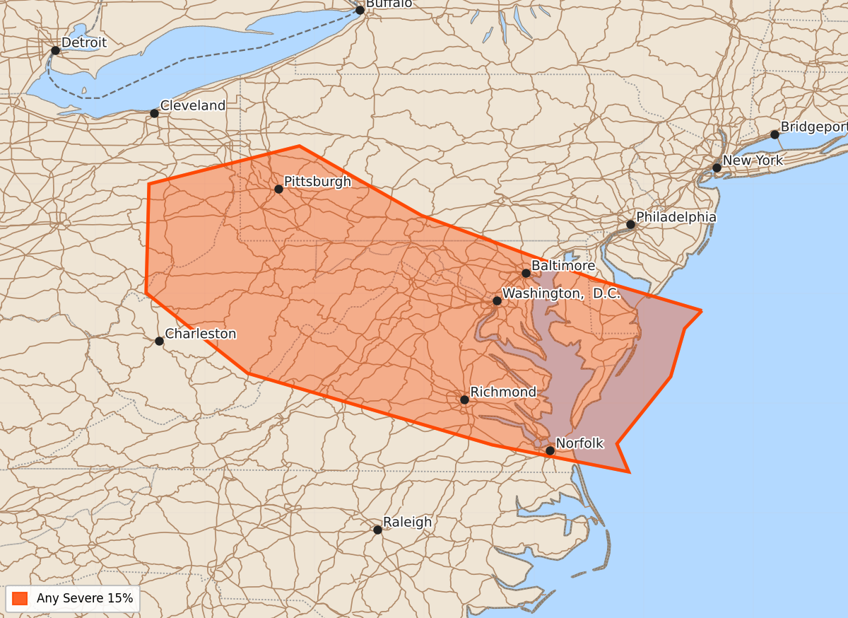
Multiple rounds of severe thunderstorms and mesoscale convective systems are expected across the eastern United States throughout the period from Sunday through Friday. The Mid-Atlantic region specifically faces a risk of severe weather on Friday.
Product Text
000 ACUS48 KWNS 120902 SWOD48 SPC AC 120900 Day 4-8 Convective Outlook NWS Storm Prediction Center Norman OK 0400 AM CDT Sun Jul 12 2026 Valid 151200Z - 201200Z ...DISCUSSION... An expansive mid-level ridge centered over the north-central US will continue to retrograde during the early part of the forecast period, before becoming centered over the Rockies toward the end of the upcoming week. A seasonably strong mid-level trough will be positioned over northern Quebec, positioning strong northwesterly flow from the Upper Midwest southeast into the Mid-Atlantic and areas to the northeast. A combination of deterministic and ensemble forecast solutions, including AI emulators, show one or more short-wave troughs or jet streaks moving through this enhanced flow field. The position of these mid-level features will help drive a surface front southward across the eastern US that will stretch from somewhere in the central/north-central US into the Mid-Atlantic. To the north of this boundary, a seasonably cool, dry airmass should be found. Along and south of this surface boundary, a very warm, moist, and unstable airmass will be found. As the aforementioned short-wave troughs move through the enhanced mid-level flow, one or more rounds of thunderstorms/mesoscale convective systems are likely to develop and move east/southeast. Ensemble guidance continues to show a very unstable airmass (MUCAPE in excess of 2000-3000 J/kg) along and south of where the surface boundary resides, with strong vertical shear. The overall pattern would seem to suggest multiple rounds/days of severe potential, with prior days' convection likely modulating the where and intensity of subsequent days' convection. Given these sensitivities to prior days' convection, there will likely be run-to-run variability within the deterministic guidance suite as we approach the latter half of next week. Thus, while confidence is high in severe potential during the Day 4-8 period (and perhaps beyond), highlighting specific locations and days of severe potential will prove challenging, with likely areas changing from model run-to-run. ... Friday/Day 6 -- Mid-Atlantic Region ... This evening's deterministic guidance suite (20260712 00 UTC), along with yesterday morning's deterministic guidance suite (20260711 12 UTC), is faster moving the surface boundary south than last night's guidance suite (20260711 00 UTC). However, the overall ensemble guidance continues to suggest severe potential across the region, owing to differences in the position of the surface boundary and the timing of mid-level vorticity maxima. Severe probabilities (15%) have been retained with this forecast in a nod to the ensemble guidance suite, but if the current trend of pushing the surface boundary farther south on Thursday (Day 5) continues, severe weather probabilities may need to be removed as the surface boundary will push south of the better deep-layer shear. ..Marsh.. 07/12/2026