Day 3 Convective Outlook
Issued: · Valid: –
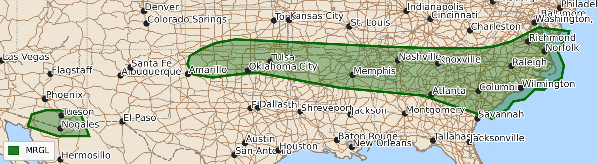
Summary
Strong to severe thunderstorms capable of producing damaging wind and large hail are possible from the southern High Plains through the Tennessee Valley to the Mid-Atlantic and Carolinas on Saturday afternoon and evening. Isolated severe storms may also occur in southern Arizona.
Product Text
000 ACUS03 KWNS 091928 SWODY3 SPC AC 091927 Day 3 Convective Outlook NWS Storm Prediction Center Norman OK 0227 PM CDT Thu Jul 09 2026 Valid 111200Z - 121200Z ...THERE IS A MARGINAL RISK OF SEVERE THUNDERSTORMS FROM THE SOUTHERN HIGH PLAINS THROUGH THE TENNESSEE VALLEY TO THE MID-ATLANTIC AND CAROLINAS... ...SUMMARY... Strong to severe storms capable of sporadic occurrences of damaging wind and large hail are possible from the southern High Plains through the Tennessee Valley to the Mid-Atlantic and Carolinas Saturday afternoon and evening. Isolated severe storms are also possible in southern Arizona. ...Synopsis... A mid/upper-level high is forecast to strengthen while shifting from the lower CO Valley and Four Corners into the central Rockies. A belt of strong mid-level winds will develop across the Pacific Northwest into northern Rockies, between the high and an upper low along the British Columbia coast. Downstream from those developments, a shortwave trough is forecast to move through New England and the Mid-Atlantic with a mid-level wind shift/shear axis stretching from the central Plains into the TN Valley. At the surface, a front is expected to move through the Mid-Atlantic with the trailing extension of the boundary stretching through the Mid South/TN Valley into the southern High Plains. ...Central and Southern Plains... Widely scattered thunderstorm development is expected by afternoon along the surface front from southern KS and OK into the OK and TX Panhandles. The steepest mid-level lapse rates will remain confined to the High Plains with increasing boundary-layer moisture content with eastward extent, both of which are expected to yield a moderately unstable environment. The 12Z models indicate a channel of stronger mid-level winds within the eastern periphery of the upper high across the High Plains, which may enhance vertical shear across that segment of the frontal zone. As such, the potential for some storm organization appears to exist with an attendant risk for large hail and severe wind gusts. ...Ozark Plateau to Tennessee Valley... The potential for early-day storms introduces forecast uncertainty due to the possibility for lingering clouds and precipitation to limit the destabilization process in some areas. Where stronger heating can occur, the presence of a moist boundary layer will contribute to moderate to strong instability by the peak of the diurnal heating cycle. The synoptic front and residual outflow boundaries will likely focus the most intense storms with the mid-level shear axis potentially enhancing background forcing for ascent. Generally weak vertical shear will limit the potential for storm organization with the primary hazard being damaging wind gusts. ...Southern Mid-Atlantic into the Carolinas... The glancing influence of the shortwave trough moving through the Northeast will combine with convergence along the front and preceding lee trough to foster scattered afternoon storms. The strongest vertical shear is expected to remain to the north of the area; however, the presence of a moist and moderately unstable air mass will be supportive of a few strong storms capable of damaging downburst winds. ...Southern Arizona... Some enhancement of mid-level winds is forecast south of the upper high, yielding a corridor of stronger deep-layer shear, which will coincide with a moist and moderately unstable air mass. That environment will be supportive of a few strong to briefly severe storms with a risk for locally damaging wind gusts. ..Mead.. 07/09/2026 $$