Day 1 Convective Outlook
This product has been superseded. View the updated product →
Issued: · Valid: –
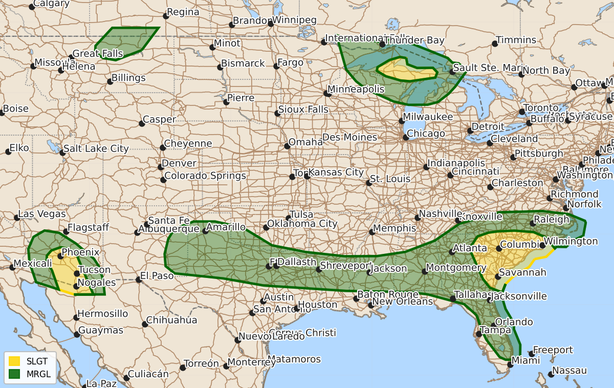
Summary
Severe thunderstorms capable of producing damaging winds and large hail are expected this afternoon and evening across parts of the Carolinas, the Southeast, the southern Plains, southern and central Arizona, and the Upper Peninsula of Michigan. These storms may result in isolated to scattered severe wind gusts and hail throughout the day and into tonight.
Product Text
000 ACUS01 KWNS 121643 SWODY1 SPC AC 121641 Day 1 Convective Outlook CORR 1 NWS Storm Prediction Center Norman OK 1141 AM CDT Sun Jul 12 2026 Valid 121630Z - 131200Z ...THERE IS A SLIGHT RISK OF SEVERE THUNDERSTORMS ACROSS PARTS OF EASTERN GEORGIA INTO THE CAROLINAS...SOUTHERN/CENTRAL ARIZONA...AND THE UPPER PENINSULA OF MICHIGAN... CORRECTED FOR OUTLOOK PROBABILITY LINES OVER GA/CAROLINAS ...SUMMARY... Thunderstorms capable of producing isolated to scattered severe/damaging winds may occur this afternoon/evening across parts of the Carolinas/Southeast into the southern Plains, and separately over southern/central Arizona. Large hail and severe winds also appear possible over portions of the Upper Peninsula of Michigan. ...Carolinas/Southeast into the Southern Plains... Midday visible-satellite imagery shows an agitated cumulus field over north-central GA to the south of a differential heating zone/weak front draped across the southern Appalachians and west to east across the Carolinas. Surface temperatures will continue to warm into the 90s F south of the more prevalent cloud cover over the Upstate of SC and western/central NC. Scattered thunderstorms will likely develop in several clusters across the Southeast with strong to locally severe gusts capable of wind damage being the primary hazard. Farther west, more widely spaced clusters will likely develop over the central Gulf Coast states into the Ark-La-Tex region. Locally damaging gusts will be possible with the stronger thunderstorms. Into parts of the southern High Plains, a seasonably moist boundary layer will become moderately unstable by mid afternoon. Steep 0-3 km lapse rates will favor isolated severe gusts with the stronger downdrafts. Considered a small Slight Risk over the TX South Plains but some uncertainty regarding storm coverage precluded higher severe probabilities this outlook update. ...Upper Midwest/Great Lakes... Northwest-flow regime will maintain a plume of elevated mixed layer air atop a moist low-level airmass. It is uncertain whether additional storm development will occur this afternoon in association with a morning cluster of strong to severe storms over parts of the U.P. Nonetheless, sufficient shear/buoyancy for supercells and organized storms structures lends a continued conditional risk for severe storms into this evening/tonight. Some guidance shows an eventual outflow-dominant cluster moving into parts of the region tonight, with some potential for damaging gusts. ...Arizona... Very strong heating will again yield a hot and well-mixed boundary layer by mid afternoon. Isolated to scattered storms are forecast to develop on the Rim and gradually propagate into the lower desert, aided by moderate easterly mid-level flow (30-kt at 500 mb sampled by the 12 UTC Phoenix raob). Strong evaporative cooling of the more water-laden downdrafts will be capable of severe gusts (60-75 mph). ...Montana... A weak front along with very strong heating may suffice for a few high-based thunderstorms to develop late this afternoon across north-central MT. Very steep low to mid-level lapse rates and deep inverted-V profiles imply some potential for severe gusts with the stronger evaporatively cooled downdrafts. ..Smith/Chalmers.. 07/12/2026 $$