Day 2 Convective Outlook
This product has been superseded. View the updated product →
Issued: · Valid: –
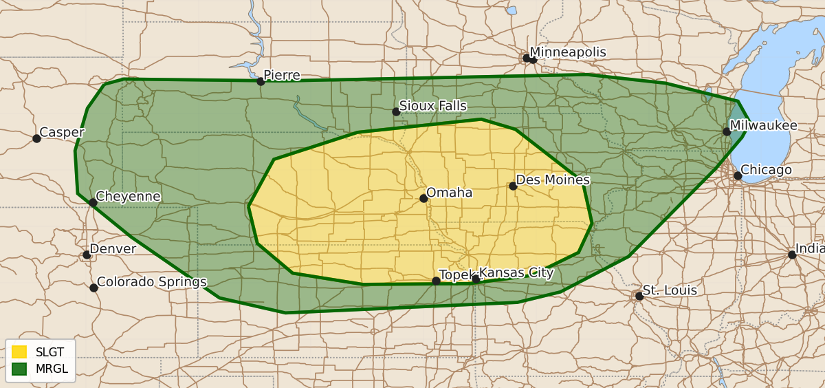
Summary
Severe thunderstorms capable of large hail and damaging wind gusts are expected Tuesday afternoon and evening across parts of the central Plains and the Lower Missouri and Mid-Mississippi Valleys. Isolated storms producing hail and strong wind gusts are also possible across the High Plains and parts of the Midwest.
Product Text
000 ACUS02 KWNS 170542 SWODY2 SPC AC 170540 Day 2 Convective Outlook NWS Storm Prediction Center Norman OK 1240 AM CDT Mon Aug 17 2026 Valid 181200Z - 191200Z ...THERE IS A SLIGHT RISK OF SEVERE THUNDERSTORMS ACROSS FAR SOUTHEAST SOUTH DAKOTA...PARTS OF NEBRASKA...NORTHERN KANSAS AND MISSOURI...AND IOWA... ...SUMMARY... Severe thunderstorms capable of large hail and damaging wind gusts are expected Tuesday afternoon/evening across parts of the central Plains and toward the Lower Missouri/Mid-Mississippi Valley. ...Central Plains to Mid/Upper MS Valley... The forecast for Tuesday has become less certain with time, with current CAMs guidance suggesting early convection across parts NE/IA/MO early in the period. This could have implication on boundary layer destabilization later in the afternoon/evening and how convection develops/evolves during that time. Nevertheless, an otherwise favorable environment for severe storms could develop as an upper trough continues to dig over the Great Lakes, leading to modest height falls across the northern/central Plains to the Midwest. Northwesterly flow aloft will increase to around 40-50 kt in the midlevels, providing support for supercell wind profiles across the region. Meanwhile, a moist boundary layer will be in place ahead of a southeastward-advancing front. Morning convection could result in a convective enhance surface boundary and/or outflow across portions of the NE/KS/MO/IA. Where stronger heating can occur within the very moist warm sector, resulting in stronger differential heating, convection is expected to develop by late afternoon into the evening. This could be storms along one or more boundaries across the broader region. Large hail and strong gusts will be possible with initial storms. A low-level jet is expected to strengthen during the nighttime hours, and some potential for MCS development is apparent, but conditional. Should this occur, potential for damaging wind gusts would increase. More isolated storms are expected across the High Plains from eastern WY/northeast CO into southwest SD/western NE/KS are expected, and into parts of MN/WI, posing a risk for strong gusts and/or hail. ...Southeast... A surface low is forecast to move across NC and lift northward along the East Coast. This will bring a surface front across the Southeast, where a very moist and moderately unstable airmass will be in place beneath deep-layer northwesterly flow. Vertical shear will remain weak, but multi-cell clusters could produce sporadic wet downbursts within the high PW environment. Overall, severe potential is expected to remain limited, precluding severe probabilities at this time. ..Leitman.. 08/17/2026 $$