Day 2 Convective Outlook
Issued: · Valid: –
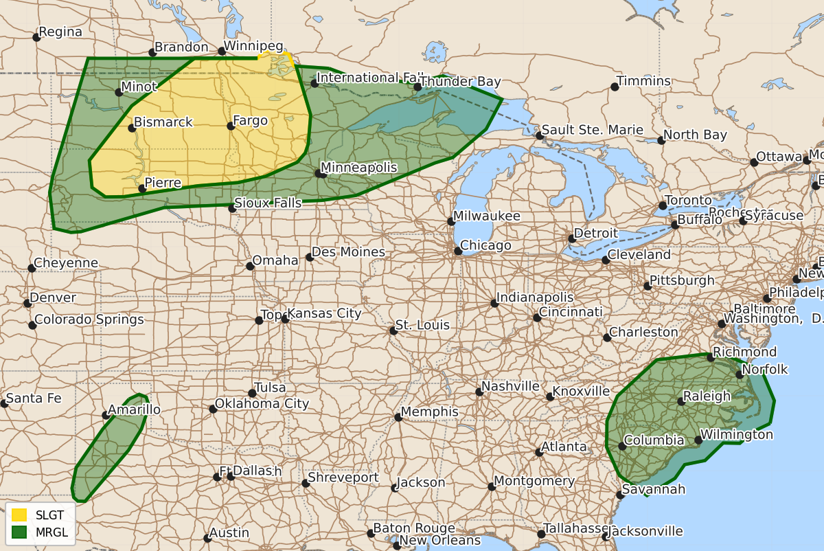
Summary
Severe thunderstorms capable of producing large hail and damaging winds are possible across portions of the Dakotas and into northern Minnesota on Sunday. Isolated severe storms with strong wind gusts may also occur in parts of the Southern Mid-Atlantic and Southern Plains on Sunday afternoon and evening.
Product Text
000 ACUS02 KWNS 271722 SWODY2 SPC AC 271721 Day 2 Convective Outlook NWS Storm Prediction Center Norman OK 1221 PM CDT Sat Jun 27 2026 Valid 281200Z - 291200Z ...THERE IS A SLIGHT RISK OF SEVERE THUNDERSTORMS ACROSS PORTIONS OF THE DAKOTAS INTO NORTHERN MINNESOTA... ...SUMMARY... Severe thunderstorms are possible from the northern Plains into parts of the Upper Midwest on Sunday. Large to very large hail and severe winds are the primary hazards. ...Northern Plains/Upper Midwest... A challenging forecast scenario is expected on Sunday across portions of the Dakotas into the Upper Midwest. Upper ridging is expected to amplify over the Mid/Upper MS Valley and western Great Lakes vicinity. This will result in capping concerns across the region owing to height rises and warming aloft, especially from the eastern Dakotas into the Upper Midwest. However, surface troughing will sharpen and extend southward across the central Dakotas into the central Plains. Meanwhile, a warm front/moisture gradient will extend southeastward from northern MN into WI and the southern Lake Michigan vicinity. Overnight, a surface low is forecast to mildly deepen somewhere from western NE into SD. Forecast guidance continues to show uncertainty in the evolution of this feature. Southeasterly low-level flow will transport rich boundary layer moisture westward across the region, with dewpoints in the mid 60s to near 70 F common. A plume of steep midlevel lapse rates will overspread the Red River and Upper MS Valley during the day, while lapse rates further west steepen during the evening/overnight. This will result in corridors of moderate to strong instability within the warm sector to the east of the surface trough and south of the warm front. However, given the building upper ridge, capping may persist across the region, limiting potential for surface-based convection. Storms are expected to be ongoing Sunday morning across the eastern Dakotas and will spread east through the day. While this activity may be elevated, large hail is possible. A southerly low-level jet is expected to persist through the daytime, and if storms can become near-surface based, some damaging wind potential also would exist. It is unclear how far east this convection may persist as it crests the building upper ridge. Overnight, convection is expected to develop near the surface low/trough on the leading edge of a strong southerly low-level jet across western or central SD. This activity may be elevated, but will likely initially be supercell mode with an attendant risk for large to very large hail. If convection grows upscale, some wind risk is also possible, but this is more uncertain given capping concerns. ...Southern Mid-Atlantic... An MCV is expected to move across the NC vicinity on Sunday. Ahead of this feature, a seasonally very moist and moderately unstable airmass will be in place. Deep-layer flow will be modest, but the MCV may locally enhance vertical shear and provide support for a band of forward propagating convection moving off the higher terrain during the after and early evening. Sporadic strong/damaging wind gusts will be possible with these storms. ...Southern Plains... A dryline will be oriented from western KS into southwest TX Sunday afternoon/evening. Strong heating is expected along the boundary along with sufficient dryline convergence. Deep boundary circulations and a narrow corridor of moderate instability will support isolated storm development. Strong downburst/outflow winds will be possible with these storms as generally weak vertical shear limits stronger updrafts longevity/organization. ..Leitman.. 06/27/2026 $$