Day 1 Convective Outlook
This product has been superseded. View the updated product →
Issued: · Valid: –
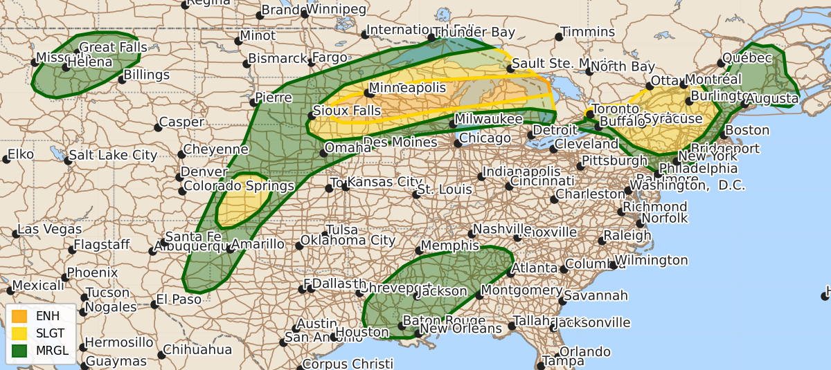
Summary
Severe thunderstorms capable of producing damaging wind gusts up to 80 mph, large hail, and occasional tornadoes are expected across portions of the Midwest and Upper Great Lakes today and tonight. Additional severe storms may occur throughout the afternoon and evening across the Central High Plains and the Northeast.
Product Text
000 ACUS01 KWNS 010602 SWODY1 SPC AC 010600 Day 1 Convective Outlook NWS Storm Prediction Center Norman OK 0100 AM CDT Wed Jul 01 2026 Valid 011200Z - 021200Z ...THERE IS AN ENHANCED RISK OF SEVERE THUNDERSTORMS ACROSS PORTIONS OF THE MIDWEST INTO THE UPPER GREAT LAKES... ...THERE IS A SLIGHT RISK OF SEVERE THUNDERSTORMS ACROSS PORTIONS OF THE CENTRAL HIGH PLAINS AND THE NORTHEAST... ...SUMMARY... Scattered severe thunderstorms are forecast across the Upper Midwest/Great Lakes today and tonight. Damaging wind gusts (some to 80 mph) are the main concern, in addition to isolated large to very large hail and a few tornadoes. Additional severe storms are possible across parts of the the central High Plains and Northeast. ...Midwest and Upper Great Lakes ... Within a belt of strong midlevel southwesterly flow extending from the central/northern Plains into the Upper Midwest/Great Lakes, a convectively augmented midlevel impulse should be the focus for ongoing/morning strong-severe storms over parts of southern MN and vicinity. This activity will mainly pose a risk for damaging gusts and possibly large hail. These storms should continue developing/spreading east-northeastward into the Upper Midwest along a stationary boundary, where diurnal heating of a moist air mass and steep lapse rates will lead to strong surface-based buoyancy. This, combined with around 40 kt of effective shear, will favor a mix of supercells and organized clusters. Scattered damaging wind gusts, large to very large hail, and a few tornadoes will all be possible. Thereafter, high-resolution guidance is in general agreement, depicting a second round of upstream thunderstorm development during the afternoon/evening in the vicinity of southern MN -- likely in response to a strengthening low-level jet and related isentropic lift. Similarly, these storms should spread east-northeastward through a strongly unstable air mass and 40-50 kt of effective shear (with increasing clockwise-curved hodographs). Swaths of damaging winds (some gusts near 80 mph possible), large to very large hail, and a few tornadoes will be possible. ...Central High Plains... High-based thunderstorm development is expected along a north/south-oriented lee trough/dryline during the afternoon and evening. Despite modest deep-layer shear (around 25-30 kt), steep low/mid-level lapse rates will contribute to a strongly unstable air mass. A mix of loosely organized clusters and possibly some supercell structures will be capable of producing severe wind gusts and large hail. ...Northeast... Enhanced west-northwesterly midlevel flow will persist across the Northeast, where a warm/moist air mass will contribute to around 3000 J/kg MLCAPE. While nebulous mesoscale forcing for ascent casts uncertainty on overall convective coverage and evolution, the strong buoyancy and a veering wind profile (albeit modest deep-layer shear) will favor east-southeastward-spreading convection capable of damaging wind gusts and isolated hail during the afternoon and again during the evening/nighttime hours. ...Southeast... Along the southern periphery of a midlevel anticyclone centered over the central Appalachians, a belt of 20-30-kt east-southeasterly flow in the 700-500-mb layer will overspread a hot/moist air mass with 4500 J/kg MLCAPE during the afternoon. Despite limited deep-layer shear, the extreme buoyancy and well-mixed boundary layer will be favorable for wet microbursts with the stronger convective clusters that evolve. ...Northern Rockies/High Plains... Isolated to widely scattered thunderstorms are expected ahead of a slow-moving midlevel trough moving across the Northwest. Preceding the trough, around 40 kt of midlevel southwesterly flow and a weakly unstable air mass will support a couple loosely organized clusters capable of producing severe wind gusts during the afternoon and evening. ..Weinman/Chalmers.. 07/01/2026 $$