Day 1 Convective Outlook
This product has been superseded. View the updated product →
Issued: · Valid: –
Summary
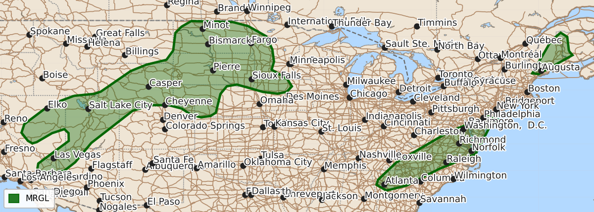
Isolated strong to severe thunderstorms are possible through Friday and into Saturday morning across the central and northern Plains, the Great Basin and Desert Southwest into the northern Rockies, northern Georgia into the Carolinas and Mid-Atlantic, and central and eastern Maine. These storms may produce damaging winds and hail.
Product Text
000 ACUS01 KWNS 281944 SWODY1 SPC AC 281942 Day 1 Convective Outlook NWS Storm Prediction Center Norman OK 0242 PM CDT Fri Aug 28 2026 Valid 282000Z - 291200Z ...THERE IS A MARGINAL RISK OF SEVERE THUNDERSTORMS FOR PARTS OF THE CENTRAL/NORTHERN PLAINS...GREAT BASIN AND DESERT SOUTHWEST INTO THE NORTHERN ROCKIES...NORTH GEORGIA INTO THE CAROLINAS AND MID-ATLANTIC...AND PARTS OF CENTRAL/EASTERN MAINE... ...SUMMARY... Isolated strong to severe storms are possible across the central and northern Plains, northern Georgia into the Carolinas and Mid-Atlantic, central and eastern Maine, and from parts of the Great Basin and Desert Southwest into the northern Rockies. ...20z Update... The previous forecast largely remains on track with only minor edits required - primarily to the general thunder line to reflect recent convective trends. Weak/poorly organized convection ongoing across the Mid-Atlantic and portions of Maine should continue to pose a localized severe threat (mainly damaging wind) through late afternoon. See MCDs #2162 and #2163 for additional short-term details. Transient downbursts have been noted across the greater Houston, TX area over the past 1-2 hours as thunderstorms develop along the sea breeze. While small swaths of damaging wind may occur with the more intense downbursts, this threat is expected to remain fairly transient given poor deep-layer wind shear across the region (wind speeds are generally 15 knots or less through the column per regional VWPs). Across the Great Basin, slight expansions of the 5% wind probabilities were made to better reflect trends in recent time-lagged CAM guidance. Some of the more aggressive solutions - notably recent runs of the RRFS - hint at one or more corridors of higher severe wind potential across eastern WY into SD as high-based convection encounters richer low-level moisture/buoyancy over the Plains. However, these solutions are exhibiting a considerable warm bias compared to current observations and suggest that any residual inhibition should be mixed out by this point in the day. Latest GOES imagery and regional 18z soundings both depict lingering inhibition, which casts considerable uncertainty onto the accuracy of the more aggressive solutions. ..Moore.. 08/28/2026 .PREV DISCUSSION... /ISSUED 1130 AM CDT Fri Aug 28 2026/ ...Maine... Morning surface analysis places a low over eastern Quebec, with a cold front extending southward from this low through northern NY before arcing more southwestward and becoming increasingly diffuse across the Upper OH Valley. A shortwave trough is forecast to progress through southern Quebec towards the St. Lawrence Valley today. The surface low is forecast to eject northeastward in response, with its attendant cold front sweeping eastward across ME. A moist airmass precedes this front, with current observations sampling mid to upper 60s dewpoints. This airmass should destabilize amid filtered daytime heating ahead of the front, although poor mid-level lapse will limit the overall buoyancy. Scattered thunderstorm development is anticipated as the cold front interacts with this modestly buoyant airmass. A few strong to severe storms are possible, but deep-layer shear largely parallel to the frontal boundary will contribute to a predominantly linear mode and a likely trend toward undercutting of new updrafts. Even so, any updrafts that can mature could organize, potentially becoming supercell storms capable of locally wind gusts and hail. ...Mid-Atlantic into Georgia... Morning surface analysis places a low off the southern New England coast and another over southern NJ (near the ongoing thunderstorms). A weak front extends through these two lows, continuing southwestward across the Carolina Piedmont into northern GA. Widely scattered thunderstorms are expected to form along the front this afternoon, with slow-moving but strong storms possible. The stronger (but still modest) deep-layer shear will occur across VA and NC, with the stronger buoyancy displaced farther south across SC and GA. Even so, the expectation is that a combination of moderate CAPE, high PWAT values, and limited deep-layer shear will promote isolated strong storms capable of water-loaded downbursts. ...Great Basin through Wyoming.. A belt of stronger mid-level flow currently extends from central CA through the northern Rockies between the upper troughing over western Canada and the upper ridging centered over the Four Corners. Low-amplitude shortwave troughs embedded within this enhanced flow, and associated ascent and mid-level moisture, will contribute to thunderstorm development this afternoon. A deeply mixed boundary layer is anticipated throughout much of this region, suggesting any of the stronger, more persistent storms could produce damaging gusts. Highest storm coverage is expected from eastern NV into central/northern UT, resulting in a relatively greater threat for damaging gusts within this corridor. ...Dakotas into western Minnesota and northern Iowa... There could potentially be two rounds of convection across the northern Plains today. The first will be with any of the high-based convection from WY as it spreads eastward into western Dakotas, where greater low-level moisture and buoyancy will be in place. The greater buoyancy could result in reintensification and a few bowing structures capable of producing locally damaging wind gusts and hail. Additional warm-air advection associated development is then possible later this evening as the low-level jet strengthens over the Plains. These elevated storms should develop within an environment characterized by moderate buoyancy and deep-layer shear, suggesting a few supercells capable of large hail are possible initially. Over time, some upscale growth is possible, which could result in a low-probability risk for damaging gusts over southwest MN and adjacent northwest IA early tomorrow morning. $$