Day 1 Convective Outlook
Issued: · Valid: –
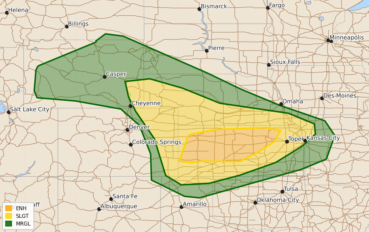
Summary
Severe thunderstorms are expected across parts of Kansas, Nebraska, South Dakota, Colorado, and Wyoming this evening and overnight, bringing the potential for large hail, damaging winds exceeding 75 mph, and tornadoes. The highest risk remains in central and northern Kansas, where intense storm clusters may produce particularly severe conditions.
Product Text
000 ACUS01 KWNS 210101 SWODY1 SPC AC 210059 Day 1 Convective Outlook NWS Storm Prediction Center Norman OK 0759 PM CDT Sat Jun 20 2026 Valid 210100Z - 211200Z ...THERE IS AN ENHANCED RISK OF SEVERE THUNDERSTORMS ACROSS PARTS OF KANSAS... ...SUMMARY... Severe thunderstorms remain likely across parts of the central Plains this evening into late tonight. Large hail, severe winds (some 75+ mph), and a few tornadoes are possible. ...Central Plains... An intense supercell cluster over northwest KS is expected to grow at least modestly upscale with time this evening, and spread east-southeastward across parts of northern/central KS, while more isolated supercells may evolve across southwest KS and move toward south-central KS through at least dusk. MLCAPE of near/above 2000 J/kg and effective shear of 50+ kt will continue to support organized storms with large hail (potentially 2+ inches in diameter with any sustained supercells), severe wind gusts (possibly 75+ mph), and some tornado potential, especially with storms that persist into richer low-level moisture across central/eastern KS. Storm evolution remains somewhat uncertain overnight into eastern KS and western MO, but a storm cluster and possible MCS may continue through the end of the period, with severe-wind potential, and some hail and tornado threat with any embedded supercells. Farther northeast, elevated supercells may continue to pose a threat of hail and isolated strong to severe gusts from southeast NE into northeast KS through dusk. See MCD 1215 for more information. To the west, a cluster of storms with a history of measured severe gusts is moving into parts of southwest SD and the NE Panhandle. Increasing CINH with time and eastward extent should result in a gradual weakening trend, though some severe threat will remain possible into mid/late evening across the NE Sand Hills region. See MCD 1218 for more information. Some threat for isolated supercells may persist farther south into northeast CO through dusk, with a threat of hail. Other remnant high-based convection may pose a threat of localized severe gusts through dusk across parts of western/central WY. ..Dean.. 06/21/2026 $$