Day 3 Convective Outlook
Issued: · Valid: –
Summary
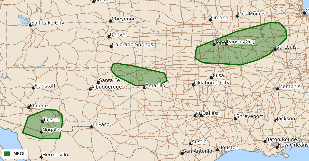
Isolated severe thunderstorms are possible Wednesday afternoon and evening across eastern Kansas into west-central Illinois, southern Arizona, and northeast New Mexico through the Oklahoma and Texas Panhandles. These storms pose a marginal risk for large hail, damaging winds, and occasional tornadoes.
Product Text
000 ACUS03 KWNS 031922 SWODY3 SPC AC 031921 Day 3 Convective Outlook NWS Storm Prediction Center Norman OK 0221 PM CDT Mon Aug 03 2026 Valid 051200Z - 061200Z ...THERE IS A MARGINAL RISK OF SEVERE THUNDERSTORMS FROM EASTERN KANSAS INTO WEST-CENTRAL ILLINOIS...OVER PORTIONS OF SOUTHERN ARIZONA...AND FROM NORTHEAST NEW MEXICO INTO THE OKLAHOMA/TEXAS PANHANDLES...... ...SUMMARY... Isolated severe storms appear possible from eastern Kansas into west-central Illinois, over portions of southern Arizona, and from northeast New Mexico into the Oklahoma/Texas Panhandles Wednesday afternoon and evening. ...Synopsis... Broadly cyclonic flow will remain across the north-central US on D3/Wednesday, with an embedded short-wave trough and associated mid-level jet streak moving through the mid and lower MO Valley. At the surface, a cold front will extend from the Great Lakes back westward into the Mid-Missouri Valley and south and west into the southern Great Plains. ...Lower Missouri/mid Mississippi Valleys into eastern Kansas... Elevated storms are likely to be ongoing at the start of the D3 period across portions of NE and IA into southern WI and northern IL. The evolution of this convection and resulting outflows will likely have impacts on placement of the front by the afternoon. This leads to some uncertainty in where the best corridor will be for renewed storm development by the afternoon. Nonetheless, guidance suggests that a corridor of moderate to strong instability will develop across portions of central Missouri/eastern Kansas. The strongest shear remains mainly parallel to and along and north of the cold front. Lapse rate profiles across central/northern Missouri are poor, but a more favorable convection free air mass with steep low to mid-level lapse rates will exist further south of the front into south-central/southern Missouri and across eastern Kansas. This narrow region of more favorable overlap of shear/instability/lapse rates may support isolated supercell development and potential for large hail, damaging winds, and perhaps a tornado. ...Southern Arizona... Convection will build again across the high terrain in southern Arizona D3/Wednesday before dropping southward into the lower deserts. While deep-layer shear will remain relatively weak, the presence of a deep, well-mixed boundary layer will support the potential for isolated severe wind gusts during the afternoon into evening. ...Northeast New Mexico into the Oklahoma/Texas Panhandles... Convective development is expected across the Sangre de Cristo Mountains and adjacent Raton Mesa Wednesday afternoon. Guidance suggests convection may also develop to the east across the OK/TX Panhandles, with potential for convection to grow upscale and potentially move across the Texas Panhandle and collide with convection out of eastern New Mexico. Given the hot/dry/well mixed air mass to the south of the front, this may pose a conditional risk for strong to severe wind and expansion of the 5% area was warranted. ..Thornton.. 08/03/2026 $$