Day 4-8 Convective Outlook
Issued: · Valid: –
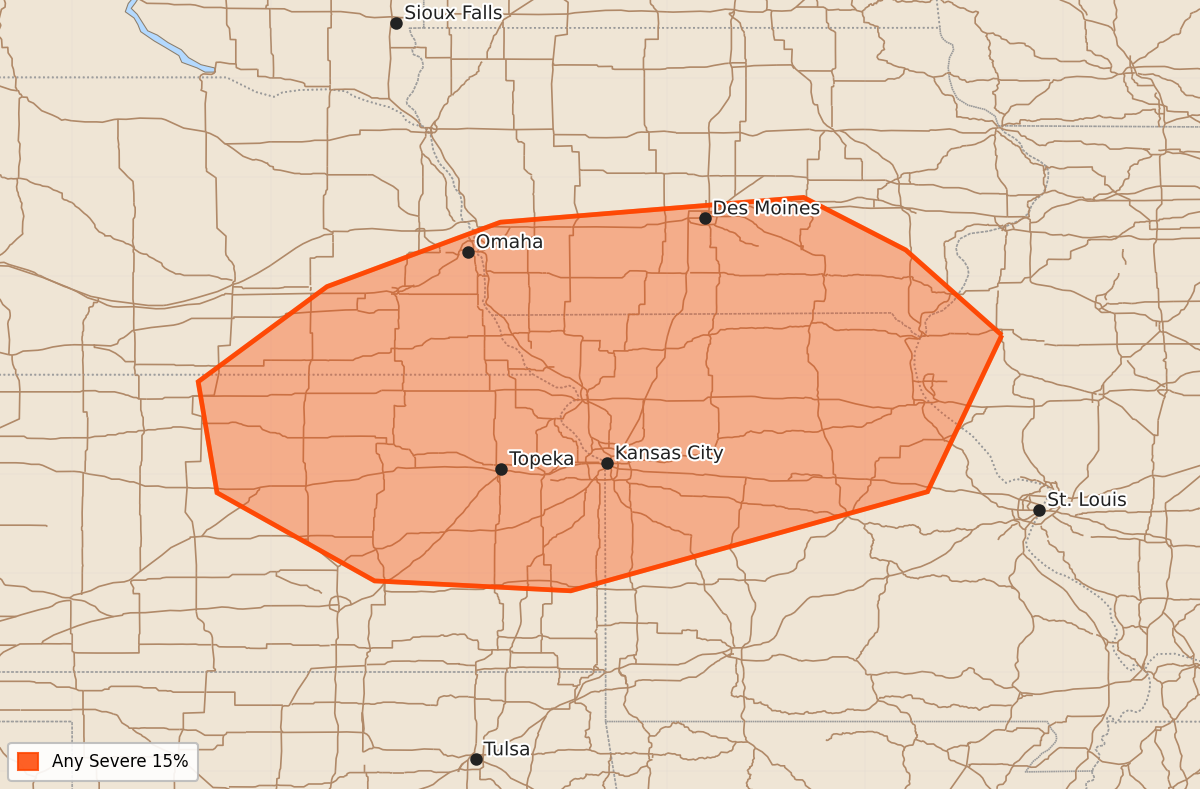
Summary
Severe storms are possible across the mid and lower Missouri Valley on Saturday, with organized supercells being a potential threat. Potential severe weather may also occur Sunday through Wednesday across the Great Lakes, Northeast, and various regions of the southern and central Plains.
Product Text
000 ACUS48 KWNS 100828 SWOD48 SPC AC 100826 Day 4-8 Convective Outlook NWS Storm Prediction Center Norman OK 0326 AM CDT Wed Jun 10 2026 Valid 131200Z - 181200Z ...DISCUSSION... ...Day 4/Saturday... The models are in generally good agreement in depicting a prominent, mid/upper-level low over Ontario with a secondary, weaker low or short-wave trough across the northern Rockies. A belt of enhanced, westerly winds in the mid levels will reside to the south of those features from the northern Plains through the Great Lakes. At the surface, an area of low pressure is forecast across the central Plains with an associated front extending northeast into the upper Great Lakes. A strongly unstable air mass is forecast ahead of the front across portions of the mid/lower MO Valley into Ozark Plateau with instability decreasing with northeastward extent into the upper Great Lakes. The models indicate sufficiently strong deep-layer shear across the frontal zone to support organized storm modes, including supercells. Highest confidence in greater storm coverage and an associated severe-weather threat remains centered on the mid/lower MO Valleys. Severe-weather probabilities may need to be extended into the upper Great Lakes in subsequent outlooks. ...Day 5/Sunday... A number of the deterministic models indicate a short-wave trough and associated jet streak moving through the Great Lakes into Northeast, within the base of the Ontario upper low. Farther west, the northern Rockies short-wave trough will advance toward the central Rockies. At the surface, a cold front associated with the former disturbance mentioned above will progress through the Northeast and OH Valley, with the western extension of the boundary stalling across the southern Plains. The models indicate a narrow axis of modest instability developing by afternoon ahead of the front from the northern New England to the upper OH Valley, where the strongest vertical shear is forecast. Some severe weather appears possible in those areas; however, the limited extent of the warm sector leads to uncertainty in the coverage and duration of any threat. Greater instability and a wider warm sector are forecast with southwestward extent from the OH River and TN Valley into southern Plains. Generally weak vertical shear is forecast across the frontal zone, which should limit the degree of storm organization. A possible exception is across the southern and central High Plains, where an easterly low-level wind component will boost deep-layer shear to some extent. Model trends will be monitored for the possible inclusion of severe-weather probabilities in that area. ...Day 6/Monday... The deterministic models are in reasonably good agreement in amplifying the aforementioned short-wave trough over the central Plains with an associated belt of enhanced mid-level flow extending through the OH Valley into Northeast. At the surface, there is some signal that an area of low pressure could develop along a front across the southern Plains into Ozark Plateau. Some severe-weather threat appears possible in that area, as well as along the front that is expected to stretch east through the TN Valley into the Carolinas. Predictability in the specific details are too low to include an area. ...Days 7-8/Tuesday and Wednesday... The ensemble mean solutions are in relatively good agreement in suggesting the central Plains short-wave trough will become absorbed into broader-scale trough amplification east of the MS Valley. At the surface, it appears that a frontal wave will move from the TN Valley toward the Mid-Atlantic coast, while a trailing cold front advances into the Gulf Coast states. While areas of severe weather are possible during this time frame, predictability in their location is low. ..Mead.. 06/10/2026