Day 3 Convective Outlook
Issued: · Valid: –
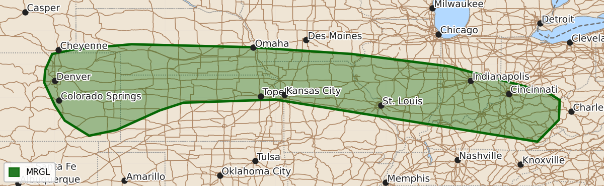
Summary
Isolated severe thunderstorms capable of producing strong wind gusts and hail are possible on Thursday across the central High Plains, the Front Range, and the middle Ohio Valley. Severe potential remains marginal throughout much of the affected area.
Product Text
000 ACUS03 KWNS 111934 SWODY3 SPC AC 111932 Day 3 Convective Outlook NWS Storm Prediction Center Norman OK 0232 PM CDT Tue Aug 11 2026 Valid 131200Z - 141200Z ...THERE IS A MARGINAL RISK OF SEVERE THUNDERSTORMS FROM THE FRONT RANGE INTO THE MIDDLE OHIO VALLEY... ...SUMMARY... Isolated severe storms are possible on Thursday from the central High Plains into the Ohio Valley. ...Central Plains into Middle Ohio Valley... Moderate to strong destabilization near and south of the surface boundary appears possible by the afternoon. Deep-layer shear will be stronger with eastern extent, but still mostly along and to the north of the boundary. Given this flow orientation, convection will likely tend to train along the front. Isolated strong gusts and wind damage are the main concern, particularly with any clusters that can develop and move into more buoyant air south of the boundary. Additional storm development is probable as the low-level jet intensifies during the evening, though storms will be more elevated by that point. ...Front Range... Moist easterly flow into the higher terrain will promote scattered storm development during the afternoon, perhaps aided by a subtle shortwave perturbation. While cloud cover may temper surface heating, steep mid-level lapse rates will allow for 1500-2000 J/kg MLCAPE. Deep-layer shear will be marginal, but a few strong to marginally severe storms may produce isolated severe winds and hail. ...Northeast... Wind fields aloft will strengthen as a mid-level jet crosses over the region on Thursday. Despite long hodographs, drier conditions (50s F dewpoints with perhaps pockets of low 60s F) will limit destabilization along with weak to modest mid-level lapse rates. A few stronger gusts and small hail could occur with the stronger activity, but severe-caliber potential still appears low. ..Wendt.. 08/11/2026 $$