Day 1 Convective Outlook
This product has been superseded. View the updated product →
Issued: · Valid: –
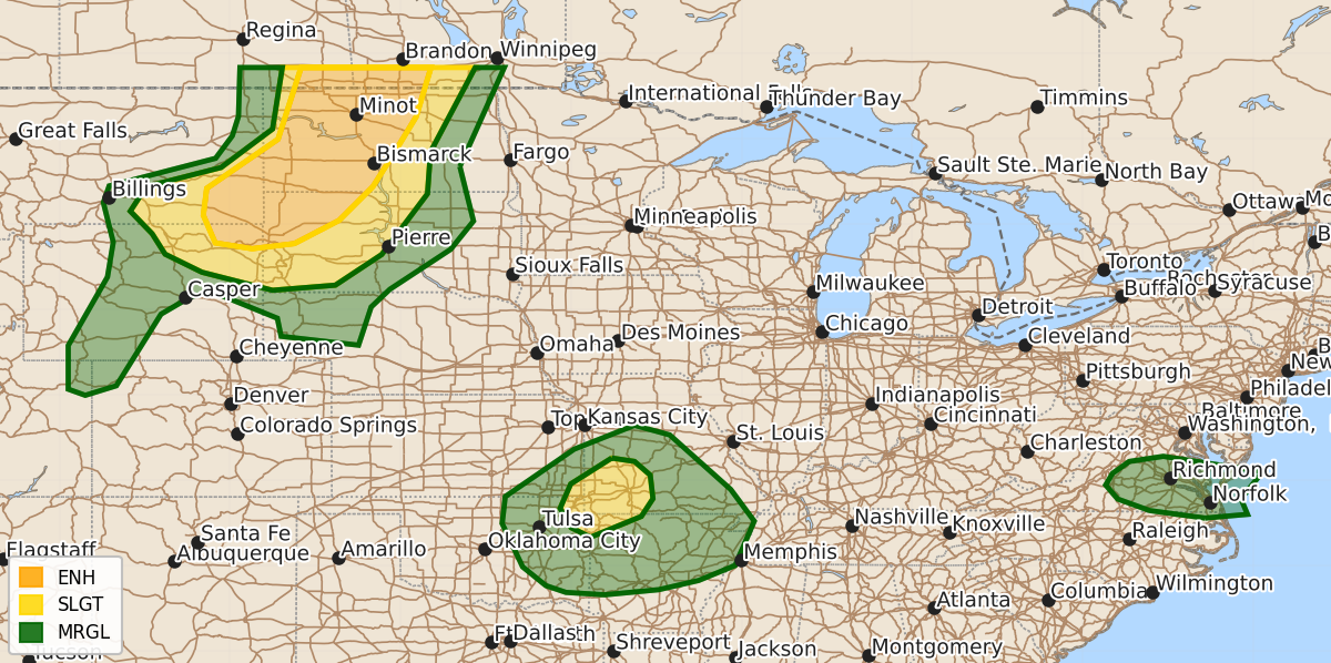
Summary
Severe thunderstorms capable of producing large hail, damaging wind gusts up to 100 mph, and an isolated tornado threat are expected this afternoon and evening across the northern Plains, including parts of Montana, Wyoming, and the Dakotas. A slight risk of severe storms with possible brief tornadoes and damaging gusts also exists across the Ozarks region throughout the afternoon and evening.
Product Text
000 ACUS01 KWNS 071641 SWODY1 SPC AC 071639 Day 1 Convective Outlook NWS Storm Prediction Center Norman OK 1139 AM CDT Sun Jun 07 2026 Valid 071630Z - 081200Z ...THERE IS AN ENHANCED RISK OF SEVERE THUNDERSTORMS FROM SOUTHEAST MONTANA AND NORTHEAST WYOMING INTO NORTHWEST SOUTH DAKOTA AND WESTERN AND CENTRAL NORTH DAKOTA... ...THERE IS A SLIGHT RISK OF SEVERE THUNDERSTORMS OVER PARTS OF THE WESTERN OZARKS... ...SUMMARY... Scattered to numerous thunderstorms with significant wind gusts, large hail, and an isolated tornado threat are expected this afternoon and evening across parts of the northern Plains. A couple of tornadoes and isolated damaging gusts are possible across the Ozarks region. ...MT/WY/Dakotas... Water-vapor imagery late this morning shows a strong upper trough over the northwestern CONUS and it is forecast to pivot eastward through the northern High Plains through tonight. Surface mesoanalysis placed a low near the MT/ND/SD border with a frontal zone draped southwest to northeast from northeastern WY into far western ND. Cyclogenesis and strong heating/moistening of the boundary layer will favor storm development by mid afternoon in the vicinity of the Big Horns. Relatively steep low-level lapse rates on the immediate cool side of the frontal zone and moderate CAPE values will support a risk of large hail and severe wind gusts once storms begin to mature. A linear cluster is expected to evolve during the late afternoon into potentially a bow echo during the early evening with the severe-wind risk notably increasing and becoming more widespread. Have increased the intensity highlight from southeast MT into western portions of ND where it seems increasingly probable a swath of intense gusts ---possibly a bow echo--- is progged by a diverse array of different model cores/runs this morning. This model signal appears reasonable given the co-location of surface features, lapse rates, and upper-level support. It is within this mesoscale corridor that localized peak gusts may range 85-100 mph. Considered an upgrade to Moderate Risk but will defer to the 20 UTC outlook for additional model run-to-run continuity and confidence in mesoscale environmental features. This activity will sweep northeastward during the evening with a gradual lessening of the wind/hail hazard towards the early overnight as it moves east into the eastern half of the Dakotas late. ...Ozarks... A weak trough/low over the central US with embedded disturbances from OK into IA continues to drift northeastward late this morning. An associated band of 30-40 knot southwesterly mid-level winds and deep moisture will lie across the Ozark plateau this afternoon. The 12 UTC Springfield, MO raob sampled this belt of stronger flow with 80-kt at 200 mb. Heating of a very moist airmass with some minor enlargement of low-level hodographs may result a few weak supercells developing coincident with peak heating. A couple of brief tornadoes and isolated damaging gusts are possible with this activity. ...Eastern VA/NC... A weak surface cold front is sagging southward across central VA this morning. A combination of strong heating and frontal forcing will lead to widely scattered thunderstorms this afternoon across southeast VA and northeast NC. The strongest of these cells could produce gusty winds. ..Smith/Chalmers.. 06/07/2026 $$