Day 1 Convective Outlook
Issued: · Valid: –
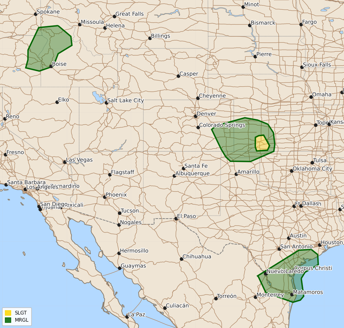
Summary
Isolated strong to severe thunderstorms are possible this evening across parts of southwest Kansas, the interior Northwest, and south Texas. These storms may bring damaging wind gusts and hail through much of the night in these regions.
Product Text
000 ACUS01 KWNS 240052 SWODY1 SPC AC 240051 Day 1 Convective Outlook NWS Storm Prediction Center Norman OK 0751 PM CDT Thu Jul 23 2026 Valid 240100Z - 241200Z ...THERE IS A SLIGHT RISK OF SEVERE THUNDERSTORMS FOR A SMALL PART OF SOUTHWEST KANSAS... ...SUMMARY... Isolated strong to severe storms remain possible this evening across parts of the central/southern High Plains, interior Northwest, and south Texas. ...Southwest KS vicinity... Convection may persist through much of the night across parts of western KS, in response to a weak midlevel shortwave trough and strengthening low-level jet. Veering wind profiles will provide sufficient deep-layer shear for occasional storm organization, though generally modest buoyancy and a tendency for much of the convection to develop/persist to the cool side of increasing outflow may tend to limit the coverage and magnitude of the severe threat. A narrow corridor near and east of Dodge City appears to have the greatest severe risk through dusk, though isolated severe gusts and hail will continue to be possible across a larger portion of the central/southern High Plains through much of the evening. ...Interior Northwest... Strong to locally severe storms remain possible early this evening from eastern OR into southeast WA and western ID. Large-scale forcing is not particularly strong, but MLCAPE approaching 1000 J/kg and moderate deep-layer shear will continue to support occasional storm organization, with a threat isolated hail and strong to severe gusts. The threat should diminish later tonight with the onset of nocturnal cooling/stabilization across the region. ...South Texas... Tropical Depression Bertha is centered over the Houston vicinity this evening. A continued weakening trend is expected through the evening (reference NHC advisories for more information). To the west/southwest of Bertha, modestly enhanced midlevel flow persists this evening, per regional VWPs. Convection with locally damaging gusts cannot be ruled out through dusk, with some threat possibly persisting into late evening into parts of Deep South Texas. ..Dean.. 07/24/2026 $$