Mesoscale Discussion 1417
Issued: · Valid: –
Summary
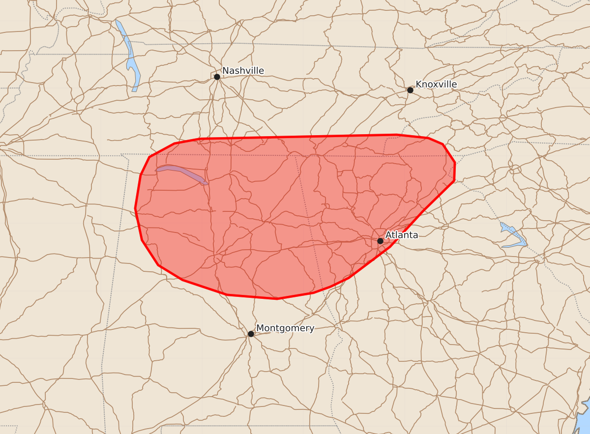
Severe thunderstorms capable of producing strong wind gusts up to 60 mph are expected to develop across northern Georgia, northern Alabama, and southern Tennessee through late afternoon.
Product Text
000 ACUS11 KWNS 011730 SWOMCD SPC MCD 011729 SCZ000-GAZ000-NCZ000-TNZ000-ALZ000-011930- Mesoscale Discussion 1417 NWS Storm Prediction Center Norman OK 1229 PM CDT Wed Jul 01 2026 Areas affected...Northern Georgia into Northern Alabama and southern Tennessee Concerning...Severe potential...Watch possible Valid 011729Z - 011930Z Probability of Watch Issuance...60 percent SUMMARY...Thunderstorm development is expected in the coming hours. Isolated to perhaps scattered strong/severe wind gusts are expected as thunderstorm coverage increases within a very unstable environment. Trends are being monitored for watch issuance. DISCUSSION...Latest GOES imagery and regional web cams show steady cumulus development and deepening across the southern Appalachians in northern GA and southern TN with at least a couple of early attempts at deep convection noted near Birmingham, AL. Any lingering inhibition is quickly being removed as temperatures continue to warm into the low to mid 90s, which will support an increasing probability for sustained convective initiation within the next 1-2 hours as parcels approach their convective temperatures and localized orographic ascent along terrain features increases. Initially isolated convection will eventually grow upscale into multi-cell clusters as development along outflow boundaries increases given weak low-level flow within a very buoyant ambient environment. With time, one or more loosely organized clusters should emerge and propagate westward given the 25-30 knot 4-5 km flow aloft sampled by regional VWPs. The combination of seasonally rich low-level moisture (dewpoints in the mid 70s and PWATs between 1.75 to 2 inches), steepening low-level lapse rates, and very high buoyancy (MLCAPE upwards of 3500 J/kg) will promote the development of intense, but localized, wet downbursts capable of producing strong/severe winds (most likely 45-60 mph). Downburst potential will gradually increase in tandem with thunderstorm coverage and daytime heating through late afternoon. Convective trends will be monitored, and watch issuance may be needed for portions of the region if thunderstorm coverage becomes sufficiently widespread and/or one or more propagating clusters emerges. ..Moore/Guyer.. 07/01/2026 ...Please see www.spc.noaa.gov for graphic product... ATTN...WFO...GSP...MRX...FFC...OHX...BMX...HUN... LAT...LON 33068510 32978535 32888589 32948663 33168729 33388765 33758789 34228799 34718791 34988778 35188741 35258703 35318412 35268365 35178344 34908326 34638327 34188373 33658422 33198483 33068510 MOST PROBABLE PEAK WIND GUST...UP TO 60 MPH MOST PROBABLE PEAK HAIL SIZE...UP TO 1.25 IN