Day 1 Convective Outlook
This product has been superseded. View the updated product →
Issued: · Valid: –
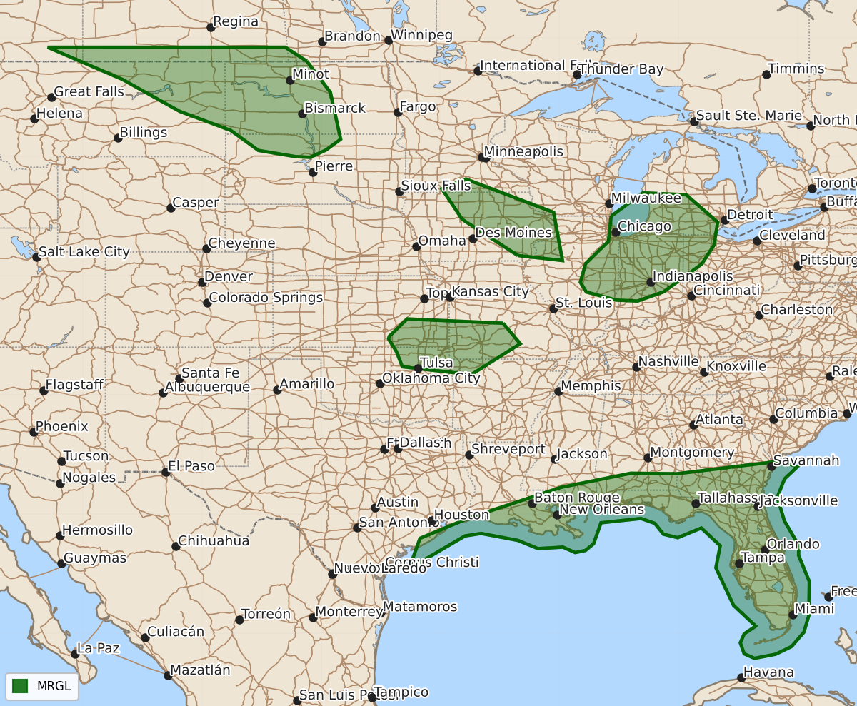
Summary
Widely scattered strong thunderstorms with a risk of severe weather are expected today through tonight across parts of the northern Great Plains, the Midwest, and near the Gulf Coast. These storms may produce severe hail, damaging wind gusts, or isolated tornadoes.
Product Text
000 ACUS01 KWNS 160551 SWODY1 SPC AC 160550 Day 1 Convective Outlook NWS Storm Prediction Center Norman OK 1250 AM CDT Tue Jun 16 2026 Valid 161200Z - 171200Z ...THERE IS A MARGINAL RISK OF SEVERE THUNDERSTORMS TODAY THROUGH TONIGHT ACROSS PARTS OF THE NORTHERN GREAT PLAINS INTO MIDWEST AND NEAR THE GULF COAST... ...SUMMARY... Areas of mainly widely scattered strong thunderstorm development, accompanied by at least some risk for severe weather, are possible across parts of the northern Great Plains into Midwest and near the Gulf Coast vicinity today through tonight. ...Discussion... Higher latitude blocking appears likely to maintain a broad area of cyclonic mid-level flow with anomalously low heights to the lee of the northern Rockies through the northern and middle Atlantic Seaboard. Within this regime, models suggest that an initially vigorous short wave trough (now digging into the Upper Midwest) may maintain strength into and across the Lake Michigan vicinity, before undergoing considerable deformation while turning eastward and northeastward, to the southeast of a mid-level becoming centered near the northern Manitoba/northwestern Ontario border. After rounding the crest of mid-level ridging centered over the northern mid-latitude eastern Pacific, it appears that another significant short wave perturbation will dig through the broadly confluent regime to the southwest of the low, across the northern Rockies through northern Great Plains by late tonight. In lower latitudes, mid/upper ridging emanating from the subtropical Atlantic may maintain considerable influence across the Florida peninsula today, while weak troughing, perhaps with a developing mid-level cyclonic circulation, slowly pivots across the lower Texas and Mexican Gulf coast. In lower levels, seasonably high boundary-layer moisture content has generally been maintained across much of the Gulf coastal plain. It appears that strengthening southerly low-level flow may support more substantive moisture return to the southeast of deepening surface troughing across the northern into central Great Plains by late tonight. ...Midwest/Great Lakes... Weak convection accompanying forcing for ascent associated with the lead short wave trough appears likely to persist and perhaps increase across the Upper Midwest through Great Lakes and Ohio Valley during the day. Coinciding low-level cooling is likely to at least slow, if not inhibit, boundary layer warming in the wake of this activity. However, various model output suggests that associated low-level moistening, coupled with a period of insolation beneath a developing mid-level dry slot, may be sufficient to support a corridor of modest destabilization as the mid-level cold pool (including 500 mb temperatures around -18 to -20C) overspreads the southern Lake Michigan vicinity late this afternoon. This environment might become sufficient for a developing broken band of vigorous convection, perhaps including supercells, posing a risk for severe hail/wind and possibly a tornado or two, before weakening later this evening. ...Central Great Plains... Forcing for ascent to support convective development along the stalling cold front, trailing the short wave trough progressing into the Great Lakes/Ohio Valley, remains unclear. However, there appears a general consensus within model output that boundary-layer moistening may support CAPE on the order of 1000-2000 J/kg across parts of southern Kansas into southwestern Missouri, where mid-level inhibition may remain weak enough through late afternoon/early evening to allow for isolated/widely scattered thunderstorm initiation. If this occurs, guidance indicates sufficient shear for supercell development, before increasing inhibition suppresses convection later this evening. ...Gulf Coast... Models indicate modest strengthening of westerly flow (including 20-40 kt in the 850-500 mb layer) in a belt across the north central through northeastern Gulf coast vicinity today. Coinciding with destabilization driven by daytime heating of the seasonably moist boundary layer, this may support modestly organizing convection, perhaps transient supercell structures, posing a risk for damaging wind gusts and perhaps an isolated tornado or two. ...Northern Great Plains into Midwest... Models suggest that a corridor of fairly deep boundary-layer mixing will precede the vigorous short wave trough digging across and east-southeast of the Canadian/northern U.S. Rockies. It appears that associated mid-level forcing for ascent will contribute to sufficient destabilization to support scattered thunderstorm development with potential to produce some hail and scattered strong to severe surface gusts late this afternoon into evening. Within strengthening downstream warm advection, forcing for ascent may begin to interact with better elevated moisture return to support increasing strong thunderstorm development with potential to producing severe hail by late tonight, across parts of eastern Iowa and adjacent portions of the Midwest. ..Kerr/Weinman.. 06/16/2026 $$