Day 1 Convective Outlook
Issued: · Valid: –
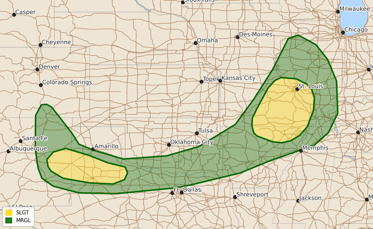
Summary
Severe thunderstorms capable of producing isolated tornadoes and damaging wind gusts are expected across the Ozarks and mid-Mississippi Valley this evening, while the southern High Plains may see isolated severe wind and hail. These storms will move through the affected areas throughout the night.
Product Text
000 ACUS01 KWNS 010100 SWODY1 SPC AC 010058 Day 1 Convective Outlook NWS Storm Prediction Center Norman OK 0758 PM CDT Fri Jul 31 2026 Valid 010100Z - 011200Z ...THERE IS A SLIGHT RISK OF SEVERE THUNDERSTORMS ACROSS THE OZARKS...MID MISSISSIPPI VALLEY AND SOUTHERN HIGH PLAINS... ...SUMMARY... Thunderstorms with severe wind gusts and an isolated tornado threat will be possible this evening across parts of the Ozarks and mid Mississippi Valley. Isolated severe gusts and hail will also be possible over the southern High Plains. ...Ozarks/Mid Mississippi Valley... Latest water vapor imagery shows a positively-tilted mid-level trough over the upper Mississippi Valley with westerly divergent flow aloft over the Ozarks. At the surface, a 1003 mb low is located over eastern Iowa with a cold front extending south-southwestward across central and southwest Missouri. Ahead of the front, low-level convergence and moisture is maximized. Surface dewpoints within this zone are in the 70s F, and the RAP has MLCAPE in the 2000 to 3500 J/kg range. Strong thunderstorms are ongoing just to the east of the instability axis over much of eastern Missouri. The storms will continue to move eastward toward the Mississippi River this evening and will eventually cross into southern Illinois. RAP forecast soundings across south-central Missouri early this evening have 0-6 km shear around 35 knots, with 0-3 km storm-relative helicity in the 200 to 225 m2/s2 range. This will support an isolated tornado threat with supercells. A tornado or two will be possible over the next couple of hours with cells that remain discrete. A gradual transition to linear mode is expected toward mid evening. The line that is currently to the west of St. Louis is expected to grow upscale, developing southward with time. The line will eventually reach southern Illinois and northeast Arkansas. A wind-damage threat will be possible along the more intense parts of this line segment. ...Southern High Plains... Mid-level flow is northwesterly over much of the southern Plains. At the surface, a cold front is located from eastern New Mexico into northwest Texas and southern Oklahoma. Scattered thunderstorms are ongoing along a narrow corridor of 60+ F surface dewpoints just to the south of the front. Within this corridor, the RAP shows moderate instability with MLCAPE in the 1500 to 2000 J/kg range. Forecast soundings early this evening along the instability axis have 0-6 km shear around 25 knots, with 0-3 km lapse rates in the 7.5 to 8 C/km range. Surface-temperature dewpoint spreads to the south of the front exceed 30 degrees F in some areas. The instability along with the steep lapse rates will support a threat for severe wind gusts for a couple more hours this evening. ..Broyles.. 08/01/2026 $$