Mesoscale Discussion 2066
Issued: · Valid: –
Summary
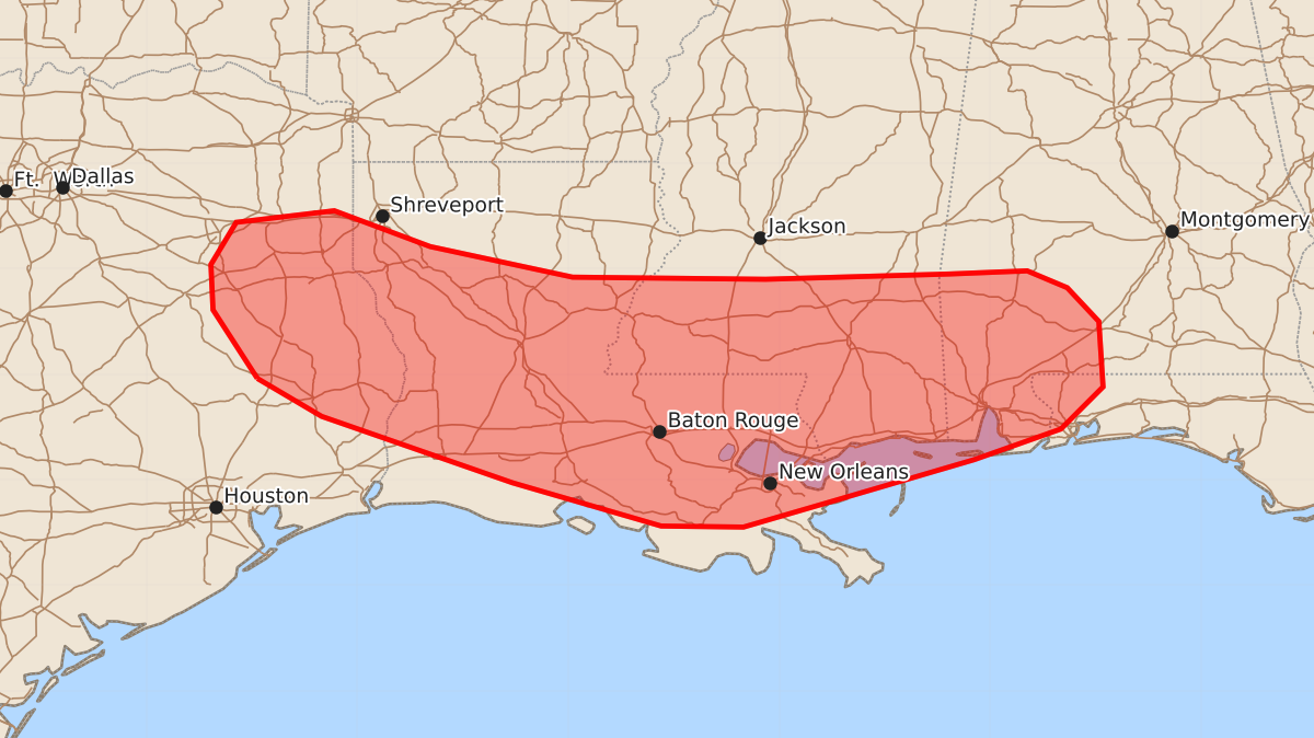
Scattered to numerous thunderstorms may bring damaging wind gusts and isolated hail to portions of eastern Texas and the central Gulf Coast this afternoon and evening. These storms are expected to produce wind gusts between 55 and 70 mph and hail up to 1.25 inches.
Product Text
000 ACUS11 KWNS 211808 SWOMCD SPC MCD 211808 ALZ000-FLZ000-MSZ000-LAZ000-TXZ000-212015- Mesoscale Discussion 2066 NWS Storm Prediction Center Norman OK 0108 PM CDT Fri Aug 21 2026 Areas affected...portions of eastern Texas into the central Gulf Coast Concerning...Severe potential...Watch possible Valid 211808Z - 212015Z Probability of Watch Issuance...60 percent SUMMARY...Scattered to numerous thunderstorms will pose a risk for damaging wind gusts and perhaps isolated marginally severe hail this afternoon and evening. A Severe Thunderstorm Watch may be needed. DISCUSSION...Latest surface analysis depicts a cold front extending from northern Mississippi westward along the Arkansas/Louisiana border and into northeastern Texas. This boundary; along with remnant outflow from overnight convection, the coastal sea breeze, and a remnant MCV evident in visible satellite imagery across central Alabama; will serve as a focus for convective initiation this afternoon amid a hot and humid air mass with temperatures in the upper-90s F and dewpoints in the mid-70s F. While effective shear remains generally meager (less than 20 kts per objective analysis and 12z regional observed soundings), modestly stronger low-to-mid level flow (20-25 kts sampled by area VWPs), high PW content (1.75-2.0+ inches), and steepening low-level lapse rates (8-9+ C/km) will support scattered damaging/severe wind gusts with water-loaded downbursts. A strongly unstable air mass (MLCAPE forecast to exceed 3000-3500 J/kg in some areas) may also promote an instance or two of marginally severe hail with the most robust cores. One or more Severe Thunderstorm Watches may be needed in the next 1-2 hour to cover this potential. ..Chalmers/Smith.. 08/21/2026 ...Please see www.spc.noaa.gov for graphic product... ATTN...WFO...MOB...JAN...LIX...LCH...SHV...HGX...FWD... LAT...LON 30969495 30609434 29979253 29569112 29559034 29808948 30198815 30488733 30888693 31508697 31828727 31988765 31958839 31909013 31929196 32219331 32559422 32449515 32049539 31619537 30969495 MOST PROBABLE PEAK WIND GUST...55-70 MPH MOST PROBABLE PEAK HAIL SIZE...UP TO 1.25 IN