Day 1 Convective Outlook
Issued: · Valid: –
Summary
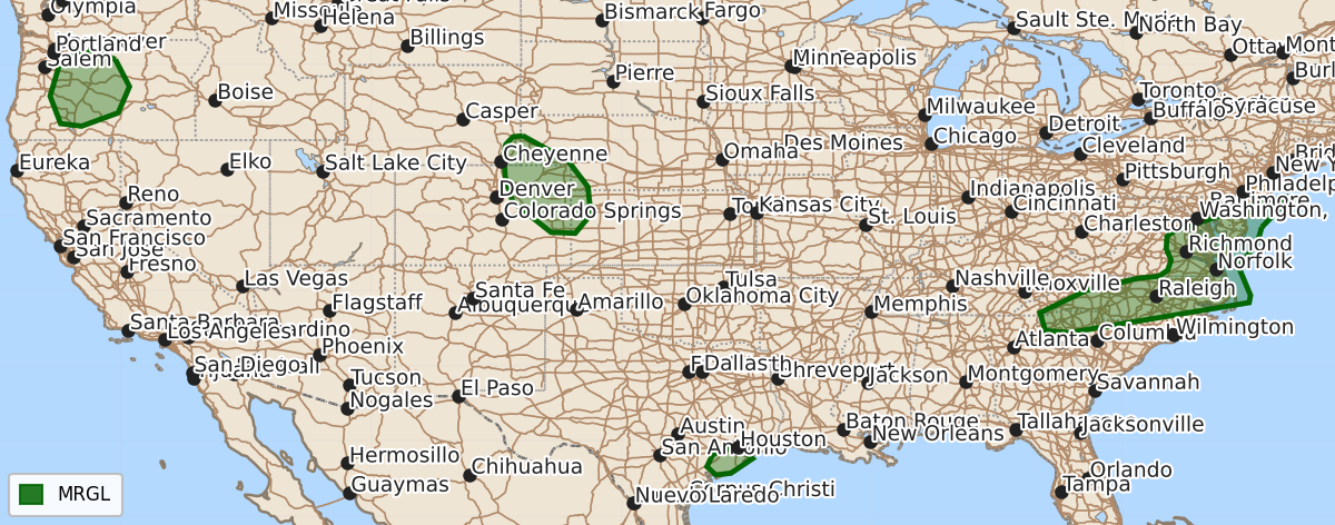
Marginal risk severe thunderstorms are expected tonight across parts of the Mid-Atlantic, the Middle Texas Coast, the Central High Plains, and Central Oregon. These storms may produce damaging wind gusts, with isolated hail also possible in the High Plains, Texas Coast, and Central Oregon.
Product Text
000 ACUS01 KWNS 230102 SWODY1 SPC AC 230100 Day 1 Convective Outlook NWS Storm Prediction Center Norman OK 0800 PM CDT Wed Jul 22 2026 Valid 230100Z - 231200Z ...THERE IS A MARGINAL RISK OF SEVERE THUNDERSTORMS ACROSS PARTS OF THE MID-ATLANTIC...MIDDLE TEXAS COAST...THE CENTRAL HIGH PLAINS...AND CENTRAL OREGON... ...SUMMARY... Isolated to widely scattered storms remain possible across the Carolinas and southern Mid-Atlantic tonight, with damaging winds being the primary concern. Isolated strong to severe wind gusts remain possible in the central High Plains, Middle Texas Coast, and central Oregon, where isolated hail will also be possible. ...Mid-Atlantic... Disorganized/weak thunderstorms are ongoing within a pre-frontal confluence zone extending from southeastern VA into western/central NC. Over the next several hours, a southwesterly low-level jet will strengthen to around 30 kt in advance of an approaching cold front. Increasing convergence/low-level ascent and a warm/moist PBL (as sampled by the MHX 00Z sounding) may support a modest uptick in thunderstorm strength over the next several hours. Around 30 kt of effective shear could promote loosely organized clusters, with the primary concern being locally damaging wind gusts. ...Middle Texas Coast... An organized cluster of storms with a history of producing severe wind gusts is tracking southwestward along the Middle TX Coast. The main severe risk will be associated with this activity as it continues southwestward over the next few hours, given a very moist/diurnally destabilized downstream air mass (lower 90s temperatures amid lower 80s dewpoints) and around 30 kt of northeasterly deep-layer shear (per the HGX VWP). ...Central High Plains... In northeast CO, thunderstorm clusters are evolving east-northeastward into a plume of increasingly rich PBL moisture (upper 50s to lower 60s dewpoints) and a belt of modestly enhanced low/deep-layer shear along the northeastern periphery of a large-scale ridge. This environment will continue to promote loosely organized clusters capable of producing severe wind gusts. For more details, see MCD #1713. ...Central Oregon... A few loosely organized cells and clusters will continue tracking northward across parts of central OR, where a belt of 30-kt midlevel flow and a weakly unstable air mass will support isolated severe wind gusts and hail with the stronger cores. ..Weinman.. 07/23/2026 $$