Day 3 Convective Outlook
Issued: · Valid: –
Summary
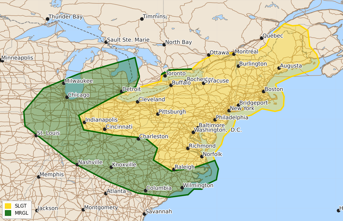
Severe thunderstorms are expected across portions of the Ohio Valley during the late afternoon and evening before moving toward the Mid-Atlantic overnight. Strong to severe thunderstorms are also possible throughout the Mid-Atlantic during the afternoon.
Product Text
000 ACUS03 KWNS 160735 SWODY3 SPC AC 160734 Day 3 Convective Outlook NWS Storm Prediction Center Norman OK 0234 AM CDT Thu Jul 16 2026 Valid 181200Z - 191200Z ...THERE IS A SLIGHT RISK OF SEVERE THUNDERSTORMS ACROSS PORTIONS OF THE OHIO VALLEY INTO THE MID-ATLANTIC... ...SUMMARY... Severe thunderstorms will be possible across portions of the Ohio Valley during the late afternoon and evening hours before moving southeast toward the Mid-Atlantic overnight. Additional strong-to-severe thunderstorms will be possible during the afternoon across portions of the Mid-Atlantic. ... Synopsis ... The CONUS-wide mid-level ridge centered over the north-central Plains for much of the past week will have retrograded west by Saturday and be located across the US and Canadian Rockies. Strong mid-level westerlies will persist on the ridge's northwest, north, and northeast periphery. Embedded within the westerlies, a series of short-wave troughs and smaller-scale vorticity/speed maxima will move across the Great Lakes and Northeast. At the start of the forecast period, the main short-wave trough will be located across central Ontario, with its associated jet streak located across the Upper Midwest. This feature will dig southeast on Saturday, ending up in the vicinity of northern New England by Sunday morning. Ahead of this main wave, the 20260716/00 UTC guidance suite shows multiple speed/vorticity maxima moving through the west-northwesterly flow, each of which will be capable of aiding the development of scattered elevated thunderstorms. At the surface, a weak surface low should develop Saturday morning across southern Ontario/the northern Great Lakes. This low will slowly deepen during the day as it digs southeast, reaching upstate New York by evening. Ahead of the surface low, southwesterly low-level flow will transport a very moist airmass northeast into the Lower Great lakes, with 70F surface dewpoints possible as far northeast as western New York. To the southwest of the surface low, a surface cold front will serve as an initiating boundary for thunderstorms during the afternoon. An unstable and strongly sheared airmass will be in place by later afternoon across Ohio northeast into western New York. As thunderstorms initiate along the front, large hail will be possible before thunderstorm outflows eventually congeal into one or more linear clusters posing a threat for damaging winds. This line of storms will push south and east during the evening and overnight with a continued threat of strong, damaging thunderstorm winds. Farther southeast across the Mid-Atlantic, most model guidance indicates the development of a surface trough to the east of the Appalachians during the late afternoon. To the east of this trough axis, temperatures will warm into the 90Fs, although there is some uncertainty how far north the hot boundary layer will extend. Given the presence of this surface trough and strong diurnal heating, several clusters of thunderstorms will be possible during the afternoon, especially if any of the previously discussed vorticity/speed maxima can interact with the low-level trough. Strong, damaging winds will be possible with any thunderstorm complex during the afternoon. Additional severe potential will also exist overnight as the remnants of the convection along the cold front approaches the region. Gusty thunderstorm winds will be the likely threat with these storms. ..Marsh.. 07/16/2026 $$