Day 3 Convective Outlook
Issued: · Valid: –
Summary
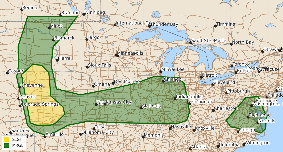
Scattered strong to severe thunderstorms may impact portions of the central Great Plains, the middle Mississippi Valley, the Ohio Valley, and parts of the Mid-Atlantic from Thursday through Thursday night. These storms could produce large hail or damaging wind gusts.
Product Text
000 ACUS03 KWNS 071854 SWODY3 SPC AC 071853 Day 3 Convective Outlook NWS Storm Prediction Center Norman OK 0153 PM CDT Tue Jul 07 2026 Valid 091200Z - 101200Z ...THERE IS A SLIGHT RISK OF SEVERE THUNDERSTORMS OVER PARTS OF THE CENTRAL HIGH PLAINS... ...SUMMARY... Scattered strong to severe thunderstorms may impact portions of the central Great Plains through middle Mississippi Valley and Ohio Valleys, and over parts of the Mid Atlantic Thursday through Thursday night. ...Central Plains... Modest 20-30 kt westerlies will exist across the High Plains, with the stronger wind speeds from MT into ND. Temperatures aloft will remain seasonably cool with -8 to -10 C from CO into MT. Storms are forecast to develop over eastern WY and CO after 21Z near the Front Range where heating will be strong, and spread across western NE, KS, and the OK Panhandle late. An MCS may develop into KS, where stronger instability will persist. Large hail appears probable with the initial activity, before transitioning to mainly damaging wind. The steep lapse rates aloft will support robust storms propagating into the backed boundary layer easterlies. ...MO eastward across IL, IN, KY... Persistent west to southwest winds near 850 mb will maintain a theta-e plume as a weak upper trough moves across the region. Early day storms are possible moving out of KS, and some reorganization is possible as the air mass destabilizes with locally damaging gusts. Afternoon activity is also expected from lower MI into northern IL, and this may increase in coverage overnight across IL and IN, perhaps into KY. Shear will be marginal in all areas, with a moist and unstable air mass. Predictability is low for this setup, but a large area of at least isolated severe gust potential is evident. ...Parts of the Mid Atlantic... A low-amplitude feature aloft with 35 kt midlevel winds is forecast to move across the Appalachians and into VA/NC area during the day. Meanwhile, a surface trough will deepen during the afternoon with a moist air mass contributing to 1500-2000 J/kg MUCAPE. The increased winds and deep shear may aid storm longevity somewhat, with cells or clusters developing and moving quickly southeast across the area. Midlevel lapse rates are forecast to remain poor, but storms coinciding with peak heating may yield a few severe wind gusts. ..Jewell.. 07/07/2026 $$