Day 3 Convective Outlook
Issued: · Valid: –
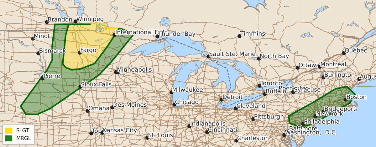
Summary
Scattered severe thunderstorms capable of producing large hail and damaging wind gusts are expected on Monday across eastern North Dakota, northwest Minnesota, and parts of northeast South Dakota. Isolated damaging winds are also possible during this time across central and eastern South Dakota into western Nebraska, as well as portions of the Mid-Atlantic and southern New England.
Product Text
000 ACUS03 KWNS 011928 SWODY3 SPC AC 011927 Day 3 Convective Outlook NWS Storm Prediction Center Norman OK 0227 PM CDT Sat Aug 01 2026 Valid 031200Z - 041200Z ...THERE IS A SLIGHT RISK OF SEVERE THUNDERSTORMS OVER EASTERN NORTH DAKOTA...NORTHWEST MINNESOTA...AND A SMALL PART OF NORTHEAST SOUTH DAKOTA...... ...SUMMARY... Widely scattered to scattered severe storms are expected across eastern North Dakota, northwest Minnesota, and a small part of northeast South Dakota Monday. Severe wind gusts and large hail will be the primary hazards. Isolated damaging winds are possible from central and eastern South Dakota into western Nebraska, and in portions of the Mid-Atlantic into southern New England. ...Synopsis... A progressive wave with unseasonably strong mid-level flow will eject across the northern Plains into the upper Midwest on D3/Monday. At the surface, a low will develop from western SD into northern MN, with a cold front advancing through the northern Plains and upper MS Valley. The southern extension of the front will push into the central High Plains. ...Northern and central Plains into the upper Mississippi Valley... Convection is expected to be ongoing near the front across portions of North Dakota into western Minnesota Friday morning as height falls overspread the region near the cold front. Early day storms may be elevated, likely posing the best potential for a few instances of large hail. Behind morning convection, steep low to mid-level lapse rates and clearing should allow for a swath of moderate instability to develop across western North Dakota into northern Minnesota by the afternoon. Thunderstorm activity is expected to redevelop near the front during this time. Supercell wind profiles will be in place with potential for large hail and damaging wind. High LCLs will likely limit the tornado potential. The air mass further south across South Dakota into southern central/Minnesota will likely remained capped and free of morning convection. Stronger heating and moistening in this region may result in moderate to strong instability. A conditional threat for supercells will be possible, limited by remaining capping at the base of the EML through the afternoon. Should storms develop, the environment would support the potential for isolated occurrences of severe wind gusts and perhaps some large hail. ...Southern New England into the Mid-Atlantic... Storms will likely be ongoing at the start of the period across southern New England into the Mid-Atlantic, which leads to uncertainty in the degree of air mass destabilization by afternoon along and ahead of the front. Where filtered heating can occur, the presence of a moist air mass will support pockets of moderate instability by afternoon. Forcing within the right entrance region of an upper-level jet streak lifting through northern New England will combine with the front to yield an increase in storms through the afternoon within a kinematic environment featuring 30-35 kt of deep-layer shear. As such, a few strong to severe storms appear possible, with the primary hazard being damaging wind gusts. ..Thornton.. 08/01/2026 $$