Day 3 Convective Outlook
This product has been superseded. View the updated product →
Issued: · Valid: –
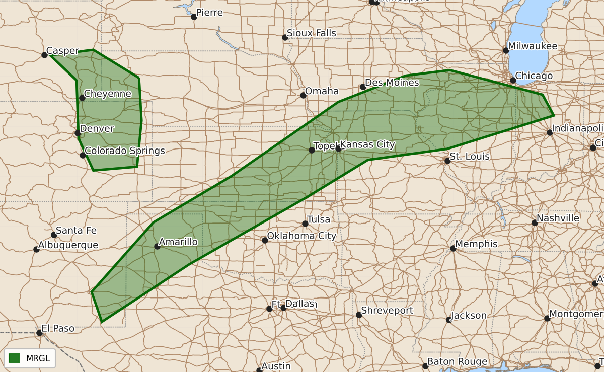
Summary
Isolated to widely scattered strong thunderstorms capable of producing severe wind and hail are possible across parts of the middle Mississippi Valley, central and southern Great Plains, and east of the Rockies this Saturday afternoon and evening.
Product Text
000 ACUS03 KWNS 170740 SWODY3 SPC AC 170739 Day 3 Convective Outlook CORR 1 NWS Storm Prediction Center Norman OK 0239 AM CDT Thu Sep 17 2026 Valid 191200Z - 201200Z ...THERE IS A MARGINAL RISK OF SEVERE THUNDERSTORMS SATURDAY INTO SATURDAY EVENING ACROSS PARTS OF THE MIDDLE MISSISSIPPI VALLEY THROUGH CENTRAL AND SOUTHERN GREAT PLAINS AND NEAR THE FRONT RANGE OF THE ROCKIES... CORRECTED FOR TYPOS ...SUMMARY... Isolated to widely scattered strong storms posing some risk for severe wind and hail are possible across parts of the middle Mississippi Valley into central and southern Great Plains, and east of the Front Range, Saturday afternoon and evening. ...Discussion... The stronger westerlies will remain confined to the northern mid-latitudes, with mid-level troughing forecast to dig across Hudson Bay, Ontario and Quebec, downstream of broad ridging overspreading the Canadian Prairies, and in the wake of a significant cyclone migrating away from the Canadian Maritimes. In response to these developments, it appears that cool surface ridging will be maintained to the east of the southern Appalachians, while the associated high center shifts off the northern Atlantic Seaboard. Another modest high is forecast to begin shifting across the central Canadian/U.S. border through much of the northern Great Plains, Upper Midwest and adjacent upper Great Lakes by late Saturday night. This will be preceded by a notable cold front advancing slowly southward into/across the Ohio and lower Missouri Valleys and central Great Plains, beneath a weaker belt of westerlies across the southern mid-latitudes. Within this regime, broad mid-level troughing is forecast to continue a slow eastward progression across the Rockies through central Great Plains, downstream of weak troughing slowly approaching the California coast. Mid-level ridging downstream of the lead trough will become increasingly suppressed across the southeastern Great Plains through lower to middle Mississippi Valley vicinity. A perturbation along it southeastern periphery may continue slowly west-southwestward across Florida and the northeastern Gulf Basin. ...Front Range vicinity into middle Mississippi Valley... Generally warm thermodynamic profiles and modest to weak vertical shear to the east of the Rockies will continue to limit the severe weather potential, but isolated to widely scattered strong thunderstorm development posing at least some risk for severe wind and/or hail appears possible in a few evolving regimes Saturday into Saturday night. Convection with potential to produce strong surface gusts may be supported by the evolution of a very warm and deeply mixed boundary layer by late afternoon, within weak pre-frontal surface troughing across parts of eastern New Mexico, the Texas South Plains and Panhandle, and northwestern Oklahoma into southeastern Kansas. Seasonably high moisture content and lift along the low-level baroclinic zone across the lower Missouri/middle Mississippi Valleys may support an upscale growing cluster or clusters of storms, which could organize sufficiently to support a period or two of strong surface gusts. Although the mid-level cold core may tend to remain to the northwest of the region through the period, cooling aloft across and southeast of the Front Range, coupled with moistening southeasterly near-surface flow, may still contribute to favorable thermodynamic profiles for a few storms capable of producing severe hail and wind, in the presence of modest shear late Saturday afternoon and evening. ..Kerr.. 09/17/2026 $$