Day 1 Convective Outlook
Issued: · Valid: –
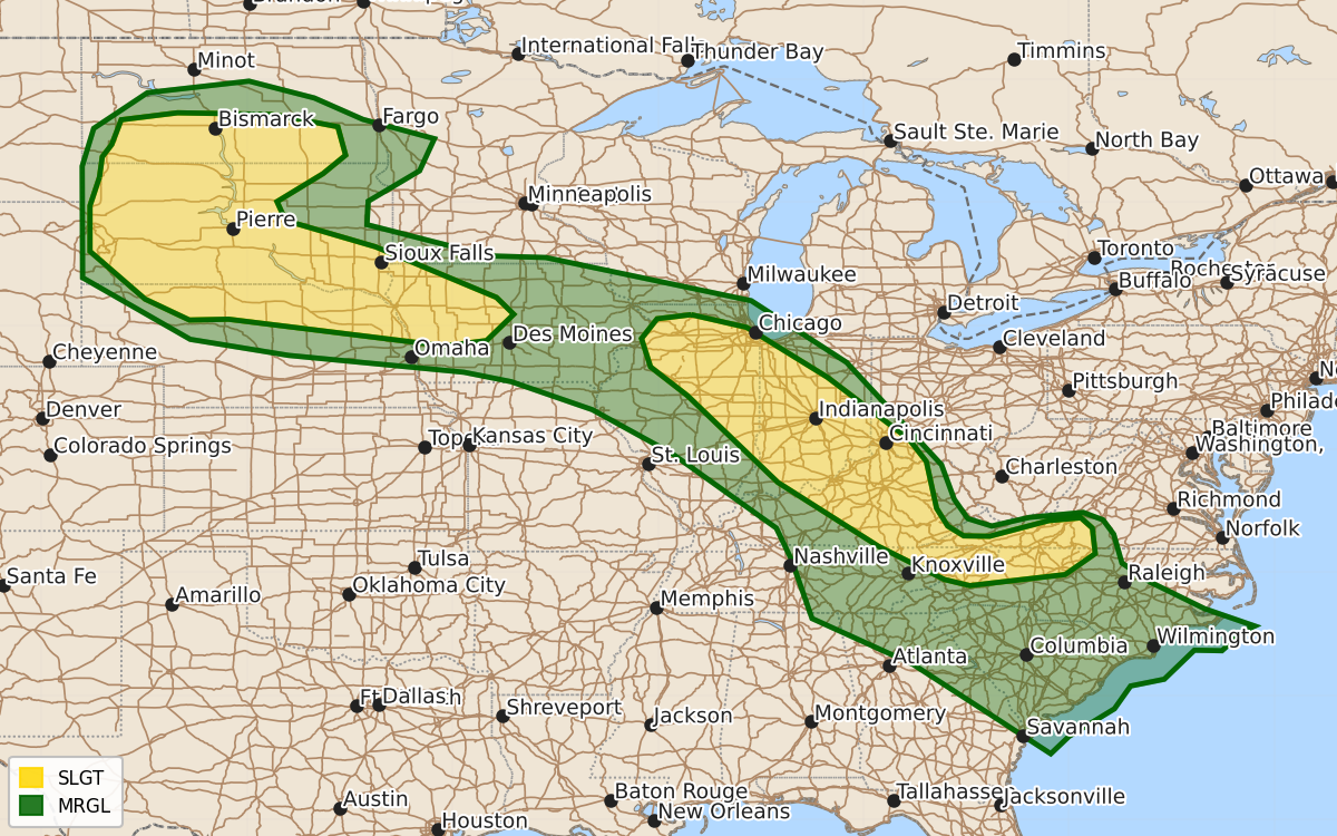
Summary
Severe thunderstorms capable of producing large hail and damaging winds are expected tonight across portions of the Dakotas, Nebraska, Iowa, the Midwest, and from Illinois to North Carolina. The risk includes a bowing line of storms bringing damaging winds through Kentucky and Tennessee, as well as potential supercells and storm clusters through the central United States.
Product Text
000 ACUS01 KWNS 120050 SWODY1 SPC AC 120048 Day 1 Convective Outlook NWS Storm Prediction Center Norman OK 0748 PM CDT Tue Aug 11 2026 Valid 120100Z - 121200Z ...THERE IS A SLIGHT RISK OF SEVERE THUNDERSTORMS ACROSS PORTIONS OF THE DAKOTAS AND NORTHERN NEBRASKA...AND FROM NORTHERN ILLINOIS TO WESTERN NORTH CAROLINA... ...SUMMARY... Severe storms posing a risk for large hail and damaging winds are possible into tonight from the Dakotas into the Midwest. ...IL to western NC... A bowing line of storms from central KY into northeast TN/western VA will continue to develop southeast the next few hours. A damaging wind risk will continue with this activity in the short term. However, convection should begin to wane with southeast extent into the Appalachians as instability wanes and loss of daytime heating results in a cooling boundary layer. Convection across KY and perhaps portions of eastern TN may remain stronger into the evening given the large reservoir of instability ahead of storms, but overall expected is for a gradual weakening trend. Reference MCD 1939 for more short term details. Overnight, most CAMs guidance suggests convection will redevelop within a warm advection regime across parts of northern IL into IN and the Ohio Valley. The 00z DVN and ILX RAOBs depict an impressive thermodynamic and kinematic environment. Midlevel lapse rates near 8 C/km amid 40 kt effective shear and MUCAPE near 5000 J/kg with weak inhibition suggests any storms developing within this environment could be severe. Convection may develop along the instability gradient and large hail is possible. If sufficient clustering occurs, damaging wind also could be possible. As a result, the Slight (level 2 of 5) risk as been expanded back to the northwest across northern IL. ...Dakotas into IA... Supercells across the western Dakotas and far northern NE will continue to pose a risk for very large hail and damaging gusts the next few hours. See MCD 1938 for short term information on severe risk. It is uncertain how convection will evolve longer-term during the overnight hours. Some guidance suggests clustering will occur and an MCS could develop, moving east/southeast across SD/northern NE and perhaps as far east as IA. Ample west/northwesterly flow aloft is in place, along with a very moist airmass with strong to extreme instability. If sufficient clustering can occur, MCS development/maintenance seems plausible. have expanded the Slight (level 2 of 5) risk eastward across SD/NE into western IA border vicinity for this possibility. ..Leitman.. 08/12/2026 $$