Day 1 Convective Outlook
This product has been superseded. View the updated product →
Issued: · Valid: –
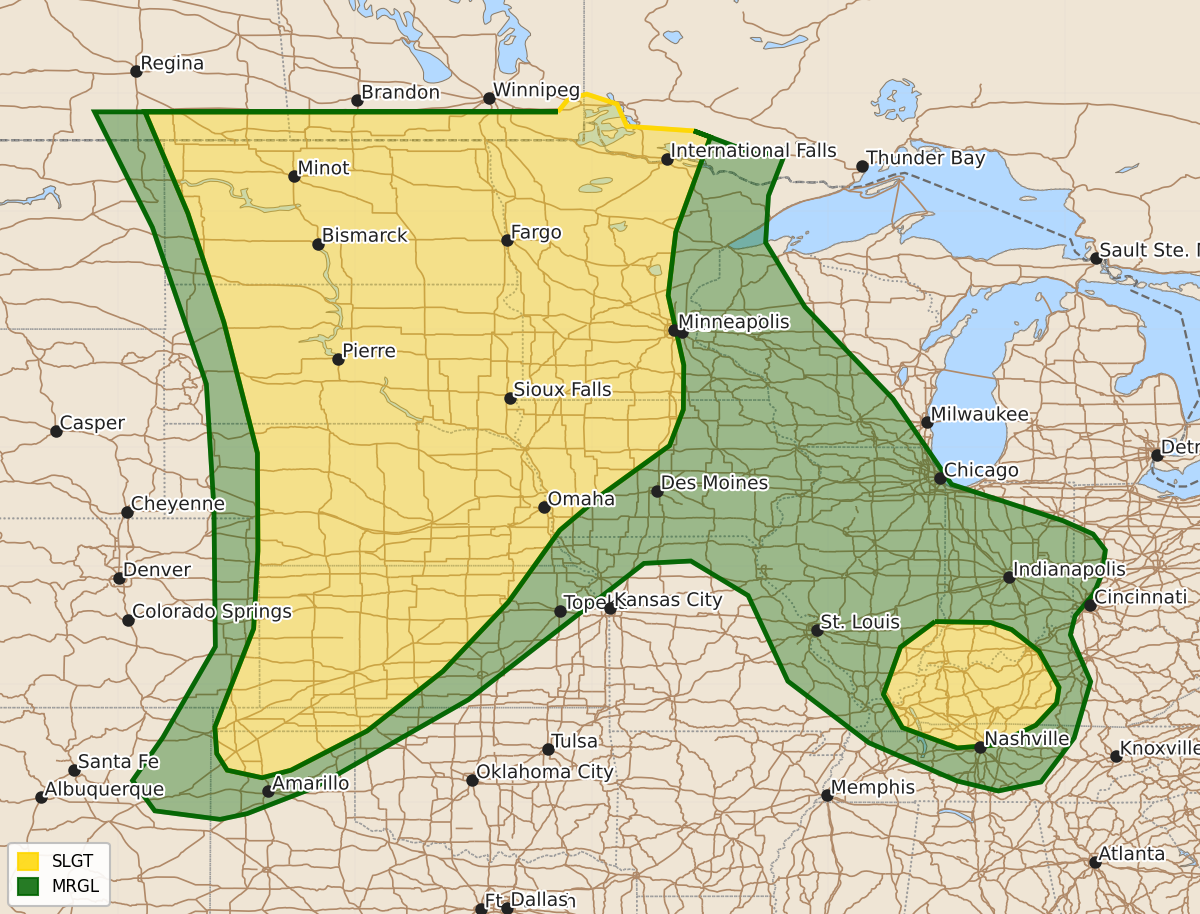
Summary
Severe thunderstorms capable of producing strong tornadoes, large hail, and damaging wind gusts up to 80 mph are expected across the central and northern Plains this afternoon and tonight. A slight risk of severe storms with damaging winds and hail is also forecast for parts of the lower Ohio Valley through the evening.
Product Text
000 ACUS01 KWNS 091955 SWODY1 SPC AC 091953 Day 1 Convective Outlook NWS Storm Prediction Center Norman OK 0253 PM CDT Tue Jun 09 2026 Valid 092000Z - 101200Z ...THERE IS AN ENHANCED RISK OF SEVERE THUNDERSTORMS ACROSS THE CENTRAL TO NORTHERN HIGH PLAINS... ...THERE IS A SLIGHT RISK OF SEVERE THUNDERSTORMS OVER PARTS OF THE LOWER OHIO VALLEY... ...SUMMARY... Numerous severe thunderstorms with a potential for 60-80 mph winds with locally higher gusts, along with tornadoes (some potentially strong), and large to very large hail are expected across the northern and central Plains this afternoon and tonight. Severe wind gusts and large hail will also be possible from north-central and west-central Kansas southwestward into the Texas Panhandle. ...20z Update... The previous forecast largely remains on track with only minor modifications made based on recent trends in observations and model guidance. ...Kansas/Nebraska... VWP observations and 18z RAOBs from Grand Junction, CO sampled a 60-70 knot speed maxima embedded within the mid-level flow at about 6 km MSL. Recent mesoanalysis estimates and model guidance appear to be under-analyzing this feature and show a more diffuse mid-level jet of around 50 knots. As this stronger flow spreads east into the Plains it will not only yield stronger deep-layer shear, but will also promote faster storm motions downstream across the central Plains. With convective initiation well underway across the High Plains of NM and CO, confidence is fairly high in the development of one or more convective bands across KS/NE later this afternoon/evening. With the expectation for stronger mid-level flow/deep-layer shear, it appears the potential for severe gusts is just as high across north-central KS/south-central NE as it is further north/south and warrants a unification of the 30% wind probabilities. ...Eastern Dakotas/western Minnesota... Latest GOES imagery and surface observations show a band of deepening cumulus within a plume of rich low-level moisture (dewpoints in the upper 60s to low 70s) through the upper Red River Valley of the North. Additionally, a subtle MCV - the remnants of prior convection over NE - is currently overspreading the region and may provide adequate forcing for ascent for initiation within the weakly capped and highly buoyant air mass this afternoon. While conditional, discrete convection that can develop within this zone could pose a tornado threat as low-level winds strengthen through the day. The 10% tornado contour was expanded eastward into western MN to better address this potential. ...Indiana/Ohio... Latest HRRR/RRFS time-lagged ensemble guidance suggests a semi-organized convective band may emerge across northern IN into western OH later this afternoon and into the evening hours ahead of an MCV (currently noted over central IL). Regional radars show the early stages of cluster development across central to eastern IL ahead of the MCV, which lends credibility to this scenario. However, outflow boundaries are noted ahead of some of this convection, hinting that the overall intensity of this activity may remain somewhat modest. Nonetheless, 5% wind probabilities were expanded downstream to highlight the potential for sporadic damaging winds. ..Moore.. 06/09/2026 .PREV DISCUSSION... /ISSUED 1135 AM CDT Tue Jun 09 2026/ ...Central and Northern Plains... Current satellite imagery shows negatively tilted upper troughing from the Pacific Northwest into the central Rockies, with an embedded shortwave trough emerging over the northern/central High Plains. This shortwave is forecast to continue northeastward today, with associated height falls spreading from the northern/central High Plains into the northern/central Plains and Upper Midwest. Recent surface analysis shows a moist airmass across the Plains, although notable airmass modification has occurred across KS and western MO from an overnight MCS. Outflow associated with this MCS currently arcs from south-central KS through extreme northeast OK and southwest MO into south-central MO. Convective outflow also exists over south-central NE. These features add to an already complex surface pattern which features several lows along a wavy surface trough from north-central MO into southeast CO. A stationary boundary also extends northeastward from the low over southeast MT through south/eastern ND and far northwest MN. General expectation is for the north/central High Plains to eject over the northern Plains, with the associated large-scale ascent and convergence along the cold front contributing to thunderstorms across a large portion of the northern and central Plains. Very strong buoyancy (i.e. MLCAPE over 2500 J/kg) will be in place across much of this region, with potential pockets of extreme buoyancy (i.e. MLCAPE over 4000 J/kg) from eastern SD through eastern NE/extreme western IA. Thunderstorms are expected to form near the front/dryline by mid/late afternoon, along the western edge of the greater buoyancy from the west-central Dakotas southward into western Nebraska. High LCLs and more southerly deep-layer shear will favor a linear mode. These linear storms will move eastward into a more moist and unstable airmass, while shear also strengthens and becomes more southwesterly, likely resulting in a one or more fast-moving convective lines. Primary hazard within these lines will be significant wind gusts (75+ mph), although increasing low-level southerly/southeasterly flow with eastern extent could also support embedded tornadoes. Hail is also possible within the stronger updrafts, particularly earlier in the convective cycle. A lower confidence, but still noteworthy, tornado risk will be associated with any more discrete development that occurs within the warm sector ahead of any convective lines. Primary forecast uncertainty results from the inherent limited predictability of the more mesoscale forcing mechanisms responsible for convective initiation east of the greater large-scale ascent. Environmental conditions support supercells capable of all hazards, including strong tornadoes, with any mature convection. Two areas that appear to have a relatively higher potential for discrete storms are east-central into northeast ND, and eastern NE into southeast SD and western IA/southwest MN. Stronger low-level flow will persist across these areas, resulting in greater warm-air advection with perhaps the realization of a discrete storm or two. ...Western and central Kansas and Texas and Oklahoma Panhandles... Persistent southwesterly flow aloft atop a diurnally destabilizing airmass is expected to support high-based thunderstorms across southeast CO/northeast NM this afternoon. These storms are then expected to persist downstream into the more unstable airmass across southwest KS, the OK Panhandle, and northern TX Panhandle. Large hail is possible early in the convective cycle but upscale growth into a more linear bowing segment is anticipated. Given the high cloud bases and steep low-level lapse rates, strong to severe gusts are also possible, including the possibility for a few gusts over 75 mph. ...Middle Mississippi Valley/Lower Ohio Valley... Airmass destabilization is anticipated this afternoon within the very moist airmass in place over the region. Thunderstorm development is expected across the region as a weak MCV, currently over central MO, tracks southeastward into the region. Shear will be modest, likely limiting storm organization, but strong buoyancy will support robust updrafts and the potential for damaging gusts. Given multiple surface boundaries and the presence of an MCV, a low-probability tornado risk exists as well. $$