Day 3 Convective Outlook
Issued: · Valid: –
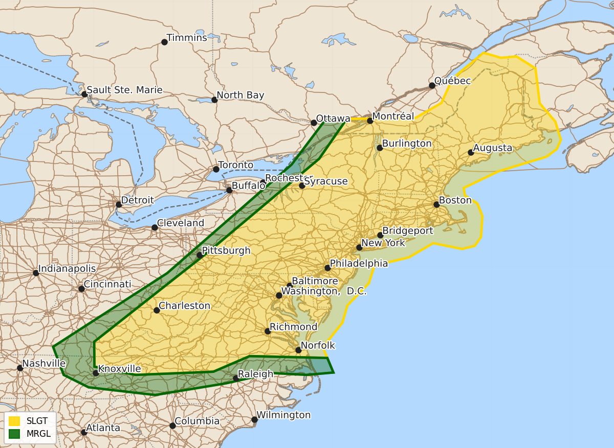
Summary
Severe thunderstorms capable of producing damaging wind gusts are expected Friday afternoon and evening across the Allegheny Mountains, the northern Mid-Atlantic, and parts of western New England.
Product Text
000 ACUS03 KWNS 101931 SWODY3 SPC AC 101930 Day 3 Convective Outlook NWS Storm Prediction Center Norman OK 0230 PM CDT Wed Jun 10 2026 Valid 121200Z - 131200Z ...THERE IS A SLIGHT RISK OF SEVERE THUNDERSTORMS FRIDAY AFTERNOON AND EVENING FROM THE ALLEGHENY MOUNTAINS VICINITY THROUGH MUCH OF THE NORTHERN MID ATLANTIC AND ADJACENT PORTIONS OF WESTERN NEW ENGLAND... ...SUMMARY... Evolving clusters of storms may spread from the Allegheny Mountains, and perhaps Poconos and Catskills, into northern Mid Atlantic coast Friday afternoon and evening, accompanied by potentially damaging wind gusts. ...Discussion... Models indicate that subtropical ridging will be maintained across much of the southern tier of the U.S. through this period. Mid-level ridging may also build within the mid-latitudes, offshore of the Pacific coast, but a largely zonal regime appears likely to be maintained from the northern Rockies through the lower Great Lakes and northern Mid Atlantic. While a secondary surface frontal low, shifting northeast of the Great Lakes region by 12z Friday, turns north/northwestward and occludes across the Hudson Bay vicinity by Friday night, the associated mid-level cyclone may only slowly shift eastward to the south-southwest of Hudson Bay. An increasingly convectively augmented trailing surface cold front appears likely to advance southeast of the lower Great Lakes through much of the Mid Atlantic by 12Z Saturday. ...Allegheny Mountains into western New England/Mid Atlantic... Models suggest that westerly deep-layer mean wind fields are likely to remain rather modest through this period, and forcing for ascent associated with one or two short wave perturbations pivoting around the periphery of the mid-level low may be glancing with respect to the evolving surface warm sector. However, guidance generally suggests that a seasonably moist pre-frontal boundary-layer (surface dew points near 70F) across the Allegheny Plateau/Mountains into the Adirondacks and Champlain/Hudson Valley vicinity may become characterized by sizable CAPE on the order of 2000+ J/kg with insolation. Preceding at least weak mid-level height falls, this environment is expected to become supportive increasing vigorous thunderstorm through early/mid Friday afternoon. Strengthening surface cold pools, perhaps aided by lower/mid-tropospheric flow on the order of 20-30+ kt, may contribute to modestly organizing clusters with potential to produce damaging wind gusts while propagating east of the higher terrain, toward the northern Mid Atlantic coast, through early Friday evening. ..Kerr.. 06/10/2026 $$