Day 3 Convective Outlook
Issued: · Valid: –
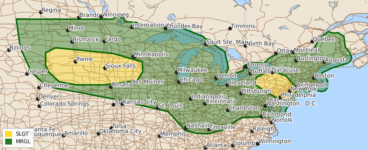
Summary
Isolated to scattered severe thunderstorms capable of producing large hail and damaging winds are possible across the northern and central Plains into the Midwest, Tennessee Valley, and Mid-Atlantic on Friday.
Product Text
000 ACUS03 KWNS 011932 SWODY3 SPC AC 011931 Day 3 Convective Outlook NWS Storm Prediction Center Norman OK 0231 PM CDT Wed Jul 01 2026 Valid 031200Z - 041200Z ...THERE IS A SLIGHT RISK OF SEVERE THUNDERSTORMS ACROSS PARTS OF THE NORTHERN AND CENTRAL PLAINS INTO MIDWEST... ...SUMMARY... Isolated to scattered severe storms are possible from the northern/central Plains into the Midwest, Tennessee Valley, and Mid-Atlantic on Friday. ...Synopsis... One or multiple mid-level disturbances over the northern and central High Plains Friday morning are forecast to progress into the upper Midwest by Friday night. Meanwhile, a downstream belt of west to west-northwest flow will prevail in the mid levels from the Great Lakes into Northeast. At the surface, a lee cyclone and attending trough will exist over the northern High Plains with a secondary low pressure center over the central Plains. An outflow-modulated warm or stationary front is expected to extend from the northern Plains low into the upper Midwest. Elsewhere, there is some model signal for the development of a surface trough from southern New England into the Delmarva Friday afternoon. ...Northern and Central Plains into the Midwest and Upper Great Lakes... The potential for early-day storms introduces forecast uncertainty in subsequent afternoon/evening severe weather potential due to the location of relevant surface boundaries and extent of convective overturning. However, by afternoon, the models indicate the development of a broad corridor of moderate to strong instability across the northern and central Plains into the southern Great Lakes and OH Valley. Diurnally enhanced thunderstorm development is most probable from the vicinity of the northern Plains lee cyclone and trough east along the outflow-modulated front within a zone of forcing for ascent preceding the disturbances mentioned in the synopsis. The instability combined with modestly strong deep-layer shear will be supportive of organized storm modes capable of large to very large hail and damaging winds with the potential for significant gusts Friday afternoon into night. ...Mid-Atlantic... Increasing height falls are forecast Friday afternoon into night downstream from a more prominent short-wave trough progressing into eastern Ontario and southwest Quebec. The various 12Z models offer different scenarios in the preferred location of diurnally enhanced storms with the best overlap extending from portions of southern NY and northern PA to the Mid-Atlantic Coast. The colocation of moderate instability and modest deep-layer shear in that area may support some storm organization with the primary hazards being damaging winds and large hail. A similar environment is forecast across the region on Saturday, July 4th, potentially warranting the inclusion of higher severe weather probabilities. ...Ohio and Tennessee Valleys... A number of models indicate the potential for one or multiple MCSs to progress through the region during the forecast period. Vertical shear is expected to be relatively weak. However, the presence of moderate to strong instability may promote periods of cold-pool organization with a related damaging wind threat. ..Mead.. 07/01/2026 $$