Day 2 Convective Outlook
This product has been superseded. View the updated product →
Issued: · Valid: –
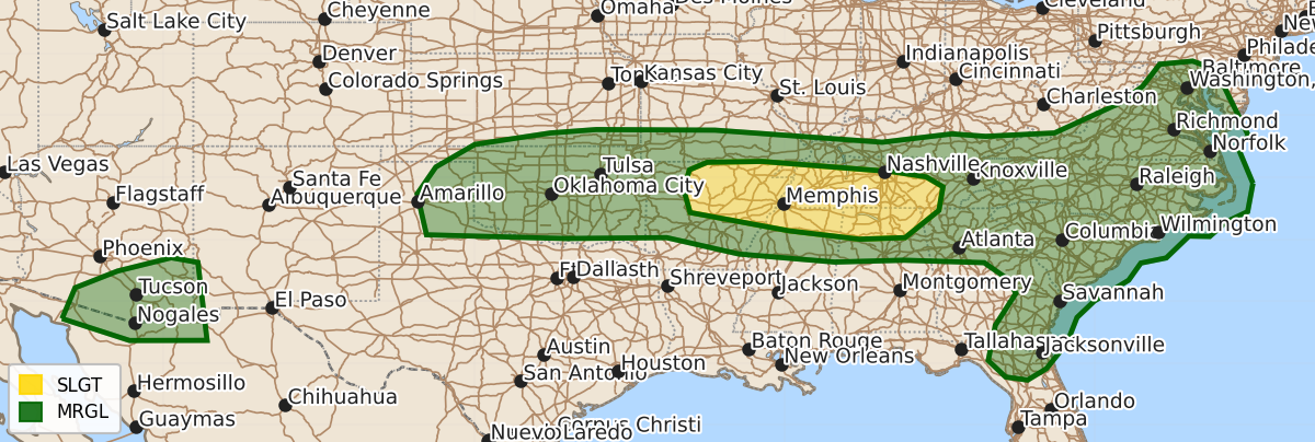
Summary
Severe thunderstorms capable of producing damaging winds are expected Friday afternoon from the Ozark Plateau through the Tennessee Valley. On Saturday, damaging winds and hail are possible across the Central and Southern Plains, the Mid-Atlantic, and northern Florida during the afternoon and evening, with isolated severe storms also possible in southern Arizona.
Product Text
000 ACUS02 KWNS 100600 SWODY2 SPC AC 100558 Day 2 Convective Outlook NWS Storm Prediction Center Norman OK 1258 AM CDT Fri Jul 10 2026 Valid 111200Z - 121200Z ...THERE IS A SLIGHT RISK OF SEVERE THUNDERSTORMS FROM THE OZARK PLATEAU INTO THE TENNESSEE VALLEY... ...SUMMARY... Severe storms capable of damaging winds will be possible from the Ozark Plateau east into the Tennessee Valley. Surrounding this area, strong to severe storms capable of sporadic occurrences of damaging wind will be possible from the southern High Plains east toward to the Mid-Atlantic and Carolinas Saturday afternoon and evening. Isolated severe storms are also possible in southern Arizona. ... Synopsis ... A strong midlevel ridge is expected to continue to build northward across the West on Saturday. Downstream of this ridge, a convectively augmented vorticity maximum is expected to be moving east-southeast across the Mid-Mississippi Valley and into the Tennessee Valley. Farther east, a mid-level short-wave trough will be moving across New England and out over the Atlantic Ocean. At the surface, a weakening cold front will stretch from far southern New England west into the central US at the start of the period. This front will slowly move south during the day, across the Mid Atlantic and into the Tennessee Valley and Southern Plains. As the aforementioned convectively augmented vorticity maximum across the central US interacts with the residual surface front, weak cyclogenesis may occur across the Mid-Mississippi Valley. ... Ozark Plateau into the Tennessee Valley ... By afternoon, temperatures are expected to warm into the mid-90Fs with dewpoints ranging from the mid 60Fs into the low 70Fs. This should yield an unstable environment, with MUCAPE values between 1500-3000 J/kg. Thunderstorms are expected to develop along the surface boundary during the afternoon. Deep layer shear is generally expected to be on the order of 20-25 knots across the area, which should support multicell clusters growing upscale into southward moving bowing segments capable of producing damaging winds. Given precipitable water values around 2 inches and mean sub-cloud layer relative humidity around 40-50 percent, there is some potential for a couple of significant wind gusts associated with strong cold pool generation. ... Central and Southern Plains ... Similar to areas farther east, temperatures will warm into the mid-to-upper 90Fs with dewpoints in the mid-60Fs to low-70Fs yielding MUCAPE values in the 1500-3000 J/kg range. Thunderstorms should develop during the late afternoon along the surface boundary. High precipitable water values (generally around 1.75 to 2 inches), DCAPE values between 1000-1500 J/kg, and sub-cloud layer mean relative humidity between 30-40 percent will support the potential for strong, damaging outflow winds -- some potentially significant. A few occurrences of large hail will also be possible given the degree of instability and modest mid-level lapse rates. Confidence in the location of where the surface boundary will initiate is lower than areas farther east, which yields lower confidence in adding higher wind probabilities. A Level 2/Slight Risk may be needed in later outlooks if confidence in the number and location of storms increases. ... Mid-Atlantic into northern Florida ... Convergence along the southward moving front and the preceding lee trough should allow for scattered thunderstorm development during the afternoon. Although vertical shear is expected to remain generally less than 25 knots, a moderately unstable environment coupled with high precipitable water values (around 2 inches) should support strong to potentially damaging downbursts. ... Southern Arizona ... East/northeast mid-level flow is forecast to strengthen slightly on Saturday to the south of the upper high, resulting in a belt of deep-layer shear on the order of 30 knots. A moist and unstable airmass across southern Arizona will support scattered thunderstorm development. As these storms move west, the strengthening flow/shear will support a few strong to briefly severe storms capable of locally damaging wind gusts. ..Marsh.. 07/10/2026 $$