Day 1 Convective Outlook
This product has been superseded. View the updated product →
Issued: · Valid: –
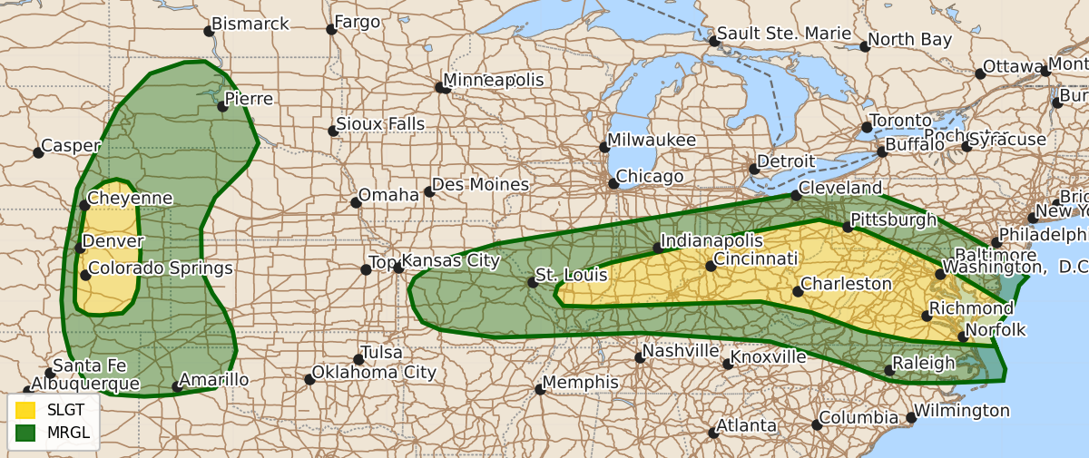
Summary
Severe thunderstorms capable of producing damaging wind gusts and large hail are expected across parts of the Ohio Valley, Mid-Atlantic, and central High Plains from this afternoon through the evening. The most significant wind threats will affect the Ohio Valley and Mid-Atlantic, while large hail and isolated wind gusts are possible in the central High Plains.
Product Text
000 ACUS01 KWNS 160557 SWODY1 SPC AC 160556 Day 1 Convective Outlook NWS Storm Prediction Center Norman OK 1256 AM CDT Sun Aug 16 2026 Valid 161200Z - 171200Z ...THERE IS A SLIGHT RISK OF SEVERE THUNDERSTORMS ACROSS PARTS OF THE OHIO VALLEY...CENTRAL APPALACHIANS...MID-ATLANTIC AND CENTRAL HIGH PLAINS... ...SUMMARY... Thunderstorms with severe wind gusts will be possible from this afternoon into early evening over parts of the Ohio Valley and Mid-Atlantic. Large hail and isolated severe wind gusts will also be possible in parts of the central High Plains. ...Ohio Valley/Mid-Atlantic... A mid-level shortwave trough, embedded in west-northwesterly flow, will move through the Ohio Valley today. Ahead of the shortwave trough, a moist airmass will be in place from the Ohio Valley southeastward to the Mid-Atlantic Coast. Surface dewpoints along this west-northwest to east-southeast corridor will be in the 70s F, which will contribute to the development of moderate instability by midday. At the surface, a cold front will advance eastward into the Ohio Valley, as a pre-frontal trough moves into the central Appalachians. These two features will focus convective development during the day. A complex of storms appears likely to form over the higher terrain in West Virginia, and move east-southeastward into the lower elevations of Virginia and Maryland during the mid to late afternoon. RAP forecast soundings from West Virginia into the Virginia in the late afternoon have 0-6 km shear in the 25 to 30 knot range. Some directional shear is present in the low-levels and 0-3 km lapse rates are steep approaching 7 C/km. This environment will support a wind-damage threat with organized multicells. Isolated supercells with severe gusts will also be possible. The threat may continue into the early evening across parts of the Mid-Atlantic. Further west into parts of the lower Ohio Valley, a very moist airmass will also be in place. Surface dewpoints in the 70s F will contribute to the development of moderate instability. Scattered thunderstorms are expected to form along zones of low-level convergence during the afternoon. Although large-scale ascent will be weaker further west, the thermodynamic environment will be sufficient for isolated severe gusts. ...Central High Plains... At mid-levels, a ridge will move through the Intermountain West today as flow remains westerly over much of the central U.S. As surface temperatures warm, scattered thunderstorms will develop in the foothills of the central Rockies. These storms will move eastward into the lower elevations of eastern Colorado and western Nebraska. RAP forecast soundings across the central High Plains by late afternoon have moderate instability (MLCAPE around 2500 J/kg), 0-6 km shear near 35 knots and 700 to 500 mb lapse rates in the 7 to 7.5 C/km range. This should support a threat for large hail and isolated severe gusts with rotating storms and organized line segments. The threat will likely persist into the evening across parts of the central High Plains. ..Broyles/Lyons.. 08/16/2026 $$