Mesoscale Discussion 1784
Issued: · Valid: –
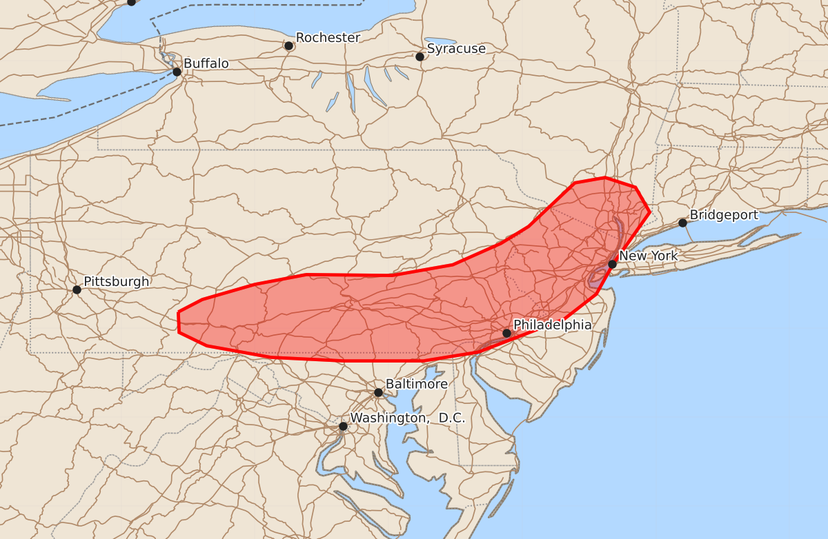
Summary
Severe thunderstorms capable of producing damaging wind gusts and hail will affect parts of southern Pennsylvania, northern New Jersey, and far southern New York through approximately 4:30 PM EDT. These storms are expected to bring wind gusts between 55 and 70 mph and hail up to 1.25 inches.
Product Text
000 ACUS11 KWNS 281831 SWOMCD SPC MCD 281830 CTZ000-NYZ000-NJZ000-PAZ000-DEZ000-MDZ000-282030- Mesoscale Discussion 1784 NWS Storm Prediction Center Norman OK 0130 PM CDT Tue Jul 28 2026 Areas affected...Southern Pennsylvania into northern New Jersey and far southern New York Concerning...Severe Thunderstorm Watch 525... Valid 281830Z - 282030Z The severe weather threat for Severe Thunderstorm Watch 525 continues. SUMMARY...A couple of corridors of relatively greater severe wind potential have emerged across portions of WW 525. These corridors will continue to be the primary axes for severe weather over the next few hours. DISCUSSION...Regional radar and velocity imagery depicts a consolidating cold pool within a loosely organized MCS across far eastern PA and northern NJ. This line has reached sufficient intensity to produce 50 mph gusts (recently measured at KABE), and will continue to reside within a thermodynamic environment adequate for MCS maintenance for at least next 1-2 hours (MLCAPE remains near 1000 J/kg downstream where temperatures are warming into the 80s). Marginal deep-layer wind shear and a relatively narrow effective warm sector should modulate overall storm intensity, but the potential for damaging wind gusts should persist downstream. Local expansions of WW 525 have been made to address this potential. Further west, a cluster of thunderstorms across south-central PA has displayed signs of a slowly deepening and organizing cold pool. Immediately downstream, a narrow corridor of partly cloudy skies has allowed temperatures to warm into the low 80s and MLCAPE to increase to near 1500 J/kg. This more buoyant air mass, coupled with around 25 knots of 0-6 km BWD sampled by KCCX, may promote further organization/intensification of the emerging line over the next 1-2 hours with an attendant threat for damaging winds. ..Moore.. 07/28/2026 ...Please see www.spc.noaa.gov for graphic product... ATTN...WFO...OKX...ALY...PHI...BGM...CTP...LWX... LAT...LON 40187886 40327859 40497800 40607742 40597646 40717578 40957524 41147493 41637441 41697407 41587373 41307357 40727398 40387417 40107453 39737549 39637611 39637700 39677782 39807854 39957885 40187886 MOST PROBABLE PEAK TORNADO INTENSITY...UP TO 90 MPH MOST PROBABLE PEAK WIND GUST...55-70 MPH MOST PROBABLE PEAK HAIL SIZE...UP TO 1.25 IN