Day 1 Convective Outlook
This product has been superseded. View the updated product →
Issued: · Valid: –
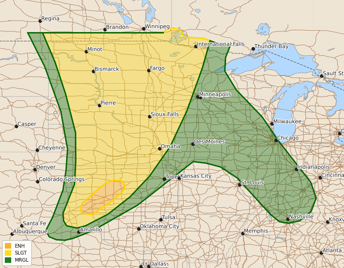
Summary
Severe thunderstorms capable of producing strong tornadoes, large hail, and winds exceeding 80 mph are expected across parts of the central and northern Plains from this afternoon into tonight. Additionally, severe wind gusts and hail are possible in north-central and west-central Kansas and the Texas and Oklahoma Panhandles during the afternoon and evening.
Product Text
000 ACUS01 KWNS 090556 SWODY1 SPC AC 090554 Day 1 Convective Outlook NWS Storm Prediction Center Norman OK 1254 AM CDT Tue Jun 09 2026 Valid 091200Z - 101200Z ...THERE IS AN ENHANCED RISK OF SEVERE THUNDERSTORMS ACROSS PARTS OF THE CENTRAL AND NORTHERN PLAINS... ...SUMMARY... Numerous severe thunderstorms with a potential for 60 to 80 mph winds with locally higher gusts, along with tornadoes (some potentially strong), and large to very large hail are expected to develop in parts of the central and northern Plains from this afternoon into tonight. Severe wind gusts and hail will also be possible from north-central and west-central Kansas southwestward into the Texas Panhandle. ...Central and Northern Plains... An upper-level trough will move eastward across the western U.S. today. Ahead of the system, mid-level heights will fall over the central and northern Plains. At the surface, a moist airmass will be in place over the Great Plains, with a dryline located from far western North Dakota southward into western Nebraska. To the east of the dryline, surface dewpoints will be in the upper 60s and lower 70s F. As surface temperatures warm today, an axis of moderate instability is expected to develop over the central Dakotas. Thunderstorms will form near and to the east of the dryline in the mid afternoon. Strong low-level convergence near the instability axis will result in a relatively rapid transition to linear mode with a large MCS expected to develop during the late afternoon and early evening. The severe MCS will move eastward across the central and eastern Dakotas, with the southern part of the line located in central Nebraska. Late afternoon RAP forecast soundings in the central Dakotas near the instability axis have MLCAPE in the 4000 to 5000 J/kg range with 0-6 km shear between 30 to 40 knots. Low to mid-level lapse rates are forecast to be in the 7 to 8 C/km range. This will be very favorable for large hail and severe wind gusts. Hailstones greater than 2 inches in diameter and wind gusts above 80 mph will be possible with supercells early, and along the more intense parts of the line as it develops. Concerning the tornado threat, a mid-level jet will become juxtaposed with a low-level jet in the late afternoon across central and northern North Dakota. Storms that can remain discrete for a few hours after initiation will have potential to become supercells and produce tornadoes. The strongest low-level shear is forecast in northeastern North Dakota, where RAP forecast soundings increase 0-3 km storm-relative helicity into the 250 to 300 m2/s2 range by early evening. This will be favorable for a few strong tornadoes. Further south from central South Dakota into Nebraska, there will be potential for supercells with tornadoes near gaps in the line. The threat for strong tornadoes may be greatest in the early to mid evening as the line interacts with a 45 to 55 knot low-level jet from far southeastern South Dakota southward into eastern Nebraska. From late evening into the early overnight period, the severe threat associated with the severe MCS is expected to gradually downtrend as it moves into the upper Mississippi Valley. ...North-central and Western Kansas/Texas and Oklahoma Panhandles... At mid-levels today, heights will fall within southwesterly flow over the southern and central High Plains. At the surface, a moist and unstable airmass will be located over much of the region. By afternoon, a focused zone of maximized low-level convergence is forecast to develop. This axis will move eastward toward the western edge of the stronger instability, with thunderstorms forming in the mid to late afternoon. Near the axis, MLCAPE is forecast to be around 2000 J/kg with 0-3 km lapse rates near 8 C/km. In addition, surface temperature-dewpoint spreads will be large, which will be favorable for severe wind gusts in the late afternoon and early evening. ...Upper Mississippi and Lower Ohio Valleys... A mid-level ridge will move eastward toward the upper Mississippi and lower Ohio Valleys today. Ahead of the ridge, moderate instability will be in place by afternoon. Scattered thunderstorms that form within this moist and unstable airmass will have potential for isolated severe gusts, mainly as low-level lapse rates become steep in the afternoon. ..Broyles/Thornton.. 06/09/2026 $$