Day 3 Convective Outlook
Issued: · Valid: –
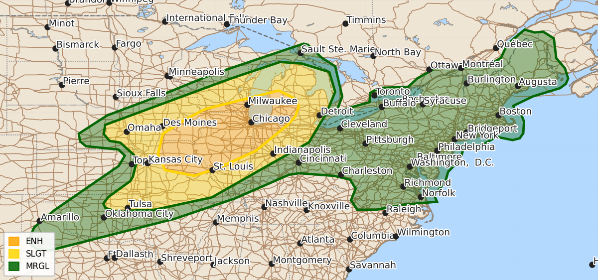
Summary
Enhanced severe thunderstorms capable of producing strong tornadoes, large hail, and destructive winds are expected Thursday across parts of the lower Missouri and Mississippi Valleys into the upper Great Lakes. Additional severe wind and large hail are possible across the southern Plains, upper Ohio Valley, and lower Great Lakes through Thursday evening.
Product Text
000 ACUS03 KWNS 091920 SWODY3 SPC AC 091919 Day 3 Convective Outlook NWS Storm Prediction Center Norman OK 0219 PM CDT Tue Jun 09 2026 Valid 111200Z - 121200Z ...THERE IS AN ENHANCED RISK OF SEVERE THUNDERSTORMS ACROSS NORTHEAST MISSOURI...EASTERN IOWA...NORTHERN/CENTRAL ILLINOIS...SOUTHERN WISCONSIN...NORTHWEST INDIANA...AND SOUTHWEST LOWER MICHIGAN... ...SUMMARY... Scattered to numerous severe storms capable of potentially strong tornadoes, large hail, and destructive winds appear likely from portions of the lower Missouri and mid Mississippi Valleys into the upper Great Lakes. More sporadic occurrences of damaging wind and large hail are possible across the southern Plains, upper Ohio Valley and lower Great Lakes toward the Mid-Atlantic Coast. ...Synopsis... A compact but potent upper shortwave trough, characterized by a 60-80 kt 500 mb jet streak, will move across the central Plains and Upper Midwest/Great Lakes vicinity on Thursday. A strong low-level jet will likely be oriented across parts of MO/KS/OK Thursday morning. Some weakening of this feature will occur as it spreads northeast through the morning, but re-invigoration of the low-level jet is forecast by mid/late afternoon. At the surface, low pressure initially over central KS will develop northeast toward Lake Michigan through 00z, and cross the international border by 12z Friday. A cold front/composite outflow from prior convection is expected to be oriented from northern WI/Upper MI southwestward into northwest OK by midday. The northern extent of the boundary will progress eastward across much of the Great Lakes and Mid-MS Valley through the period, while the western extent stalls over OK and the TX Panhandle. ...Upper Great Lakes to Lower MO/Mid-MS and Lower Ohio Valleys... An MCS may be ongoing in the vicinity of eastern NE/southwest IA Thursday morning. Ahead of this feature and the aforementioned cold front, a very moist airmass will remain in place across the Midwest (upper 60s/low 70s dewpoints). Strong destabilization will be possible (2500-4500 J/kg). Reintensification or redevelopment of morning convection is possible as this activity encounters the instability gradient from eastern IA into northern IL and Lower MI. Favorable vertical shear profiles will support supercells and bowing segments capable of significant wind gusts, large hail (with more discrete convection), and strong tornadoes through the afternoon, centered on eastern IA, northern IL, far southern WI and perhaps as far east as southern Lower MI/northern IN. With time, additional convection will develop along the cold front from central IL into southwest MO. Very large hail and damaging wind gusts will be the main hazard with this activity as it spread east/southeast across the Ozarks and toward the Lower Ohio Valley through evening. ...Southern Plains... Convective coverage is a bit more uncertain with southwest extent into OK/TX. Stronger large-scale ascent will be focused further northeast, but strong instability, rich boundary layer moisture and steep lapse rates near the sagging cold front and a dryline should foster at least isolated storm development where capping can be overcome. Supercells in this environment would pose a risk for severe wind gusts and large hail. ...Upper Ohio Valley to Mid-Atlantic... A weak disturbance is forecast to move through an upper ridge across the region, resulting in modest enhancement to northwesterly flow aloft. Strong heating and rich boundary layer moisture will support moderate destabilization during the afternoon/early evening. Scattered thunderstorms will pose a risk for strong to isolated severe wind gusts and sporadic wind damage. ..Leitman.. 06/09/2026 $$