Day 3 Convective Outlook
Issued: · Valid: –
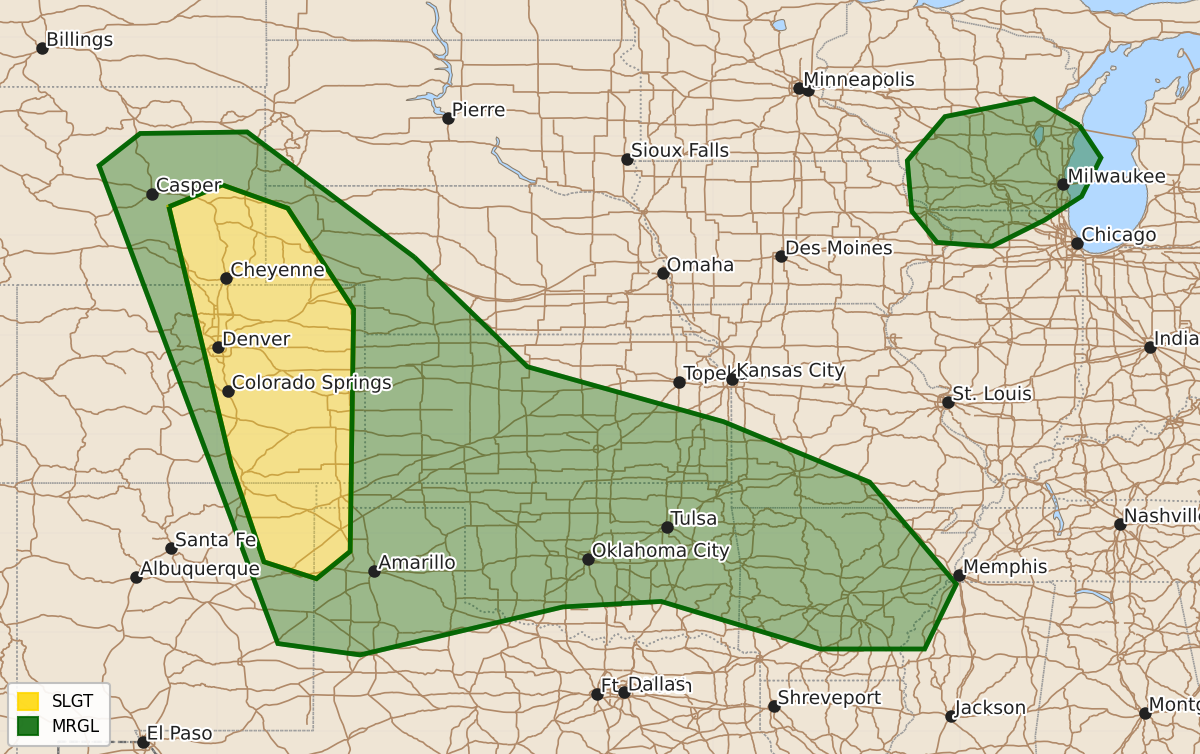
Summary
Widely scattered severe thunderstorms are possible across the central and southern High Plains on Wednesday, primarily bringing a threat of large to very large hail. Isolated severe storms may also develop across portions of the upper Midwest during the afternoon.
Product Text
000 ACUS03 KWNS 221931 SWODY3 SPC AC 221930 Day 3 Convective Outlook NWS Storm Prediction Center Norman OK 0230 PM CDT Mon Jun 22 2026 Valid 241200Z - 251200Z ...THERE IS A SLIGHT RISK OF SEVERE THUNDERSTORMS ACROSS PORTIONS OF THE CENTRAL AND SOUTHERN HIGH PLAINS... ...SUMMARY... Widely scattered severe storms are possible across the central High Plains on Wednesday with a threat for large to very large hail. More isolated severe storms are possible across portions of the upper Midwest. ...Synopsis... A short-wave trough is forecast to move from the upper MS Valley into the upper Great Lakes ahead of a sheared vorticity maximum translating from the northern Rockies into the northern and central Plains. Those features will be associated with a belt of enhanced mid-level flow extending from the northern and central High Plains into the Great Lakes. At the surface, an area of low pressure is forecast to weaken over the upper Midwest, along a cold front advancing through that area. The western extension of that boundary will become increasingly less defined with southwestward extent into the central and southern Plains. ...Central and Southern High Plains to the lower Mississippi Valley... As was the case for the Day 2 (Tuesday and Tuesday night) forecast period, there is considerable spread in 12Z model guidance in the location of any ongoing MCS(s) at 12Z Wednesday. The location of those features will dictate the specific location of any more concentrated damaging-wind risk later Wednesday, especially from the Ozark Plateau into lower MS Valley. There is higher confidence in widely scattered afternoon storm development across the central and perhaps southern High Plains within a low-level, upslope regime. The combination of moderate instability and 35-50 kt of deep-layer shear will support supercells capable of large to very large hail as the primary hazard. There is some model signal that the afternoon High Plains storms will grow upscale into an MCS across lower elevations of the central Plains Wednesday night with an associated damaging-wind risk. Confidence in that scenario is currently too low to extend the 15% probability contour farther east at this time. ...Upper Midwest... Lingering clouds associated with early-day storms may limit air mass destabilization into afternoon. However, where cloud breaks can occur, the combination of cooling temperatures aloft and modest boundary-layer moisture content will support moderate afternoon instability. Widely scattered thunderstorms are expected to develop during the afternoon in the vicinity of the surface low and frontal boundary, and within the belt of stronger mid-level flow, suggesting some potential for large hail with the strongest updrafts. ..Mead.. 06/22/2026 $$