Day 1 Convective Outlook
This product has been superseded. View the updated product →
Issued: · Valid: –
Summary
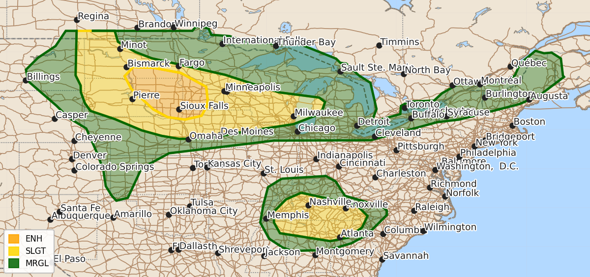
Severe thunderstorms are expected today and tonight across the northern Plains, Midwest, and Great Lakes, with an enhanced risk of large hail and damaging winds. Additionally, scattered severe thunderstorms capable of producing damaging wind gusts and isolated hail are forecast for the southern Appalachians, Tennessee Valley, and parts of the Northeast this afternoon and evening.
Product Text
000 ACUS01 KWNS 021245 SWODY1 SPC AC 021243 Day 1 Convective Outlook NWS Storm Prediction Center Norman OK 0743 AM CDT Thu Jul 02 2026 Valid 021300Z - 031200Z ...THERE IS AN ENHANCED RISK OF SEVERE THUNDERSTORMS FOR PORTIONS OF THE UPPER MIDWEST... ...THERE IS A SLIGHT RISK OF SEVERE THUNDERSTORMS FROM THE DAKOTAS INTO THE WESTERN GREAT LAKES AND OVER THE SOUTHERN APPALACHIANS AND TENNESSEE VALLEY... ...SUMMARY... Scattered to numerous severe storms will be possible from the northern Plains into the Midwest and Great Lakes regions today into tonight, as well as across the southern Appalachians and Tennessee Valley this afternoon and early evening. ...Northern High Plains into the Great Lakes and Midwest... A belt of moderate southwesterly flow will extend across the north-central states through the period. A few ongoing clusters of showers/thunderstorms extend along residual outflow from WI to along the MN-IA border vicinity. Farther west, a weak low analyzed near the Black Hills and associated lee trough will aid in maintaining southerly flow to the south of a residual frontal zone draped over SD east-northeastward to near Lake Superior. Some isolated severe risk may continue this morning with a small cluster along the Dakotas border primarily to the north of the front. Heating of a seasonably moist airmass (60s deg F north and 70s across eastern NE into IA) will contribute to moderate to strong instability by late afternoon. Afternoon thunderstorm development is expected near the surface low and in the vicinity of the surface boundary/residual outflow across the Dakotas. Forecast model data indicates deep-layer shear around 40-45 kts which will support initial supercells capable of large to very large hail and severe gusts. As additional storms develop and cold pools merge and result in a few clusters evolving with time, the wind threat will likely increase with stronger gusts associated with bowing segments. This activity will likely persist well into the evening with some lingering severe potentially into the overnight over the MN-IA vicinity late. ...Southern Appalachians into the Tennessee/Ohio Valleys... A seasonably moist boundary layer is evident in surface observations (lower 70s F surface dewpoints) this morning. Relatively cool 500-mb temperatures around -9 deg C (reference the 12 UTC Nashville, TN raob) and strong heating will result in fairly steep lapse rates across this region by early to mid afternoon. Scattered thunderstorms are likely and a few stronger clusters will probably evolve within a weak easterly flow regime to the southwest of an mid-level anticyclone centered over southwest VA. The steepened 0-2 km lapse rates and high PW (1.5-1.75 inches) will support wet microbursts capable of strong to severe gusts (locally 60-70 mph) with the more intense water-loaded downdrafts. Modifying the Nashville raob for forecast afternoon high temperatures in the upper 90s deg F yields extreme MLCAPE (4000+ J/kg). Due to the magnitude of buoyancy, have highlighted higher probabilities to account for increased confidence in a wet microburst threat. Isolated hail may also accompany the more intense updrafts. This activity will probably coalesce into a few clusters that gradually weaken during the evening as the wind-damage threat subsides. ...Central High Plains... Isolated thunderstorms are expected to develop within the lee trough across the central High Plains this afternoon. Moderate instability overlapping with around 25-30 kts of deep-layer shear will support potential for a mix of supercells and multicell clusters. Steep low- to mid-level lapse rates and large temperature/dew point spreads will support potential for severe gusts. Initial supercells will pose potential for large hail. ...Northeast... Northeasterly flow within the northern periphery of the eastern ridge will allow for thunderstorm activity to track southward out of Quebec/Ontario across portions of the Northeast this afternoon. Uncertainty remains regarding details of convective evolution and potential corridors of greater threat. Nonetheless, moderate to strong instability and 30-40 kt of deep-layer shear will support storm organization, with damaging gusts being the primary hazard with the stronger storms. ..Smith/Dean.. 07/02/2026 $$