Day 1 Convective Outlook
Issued: · Valid: –
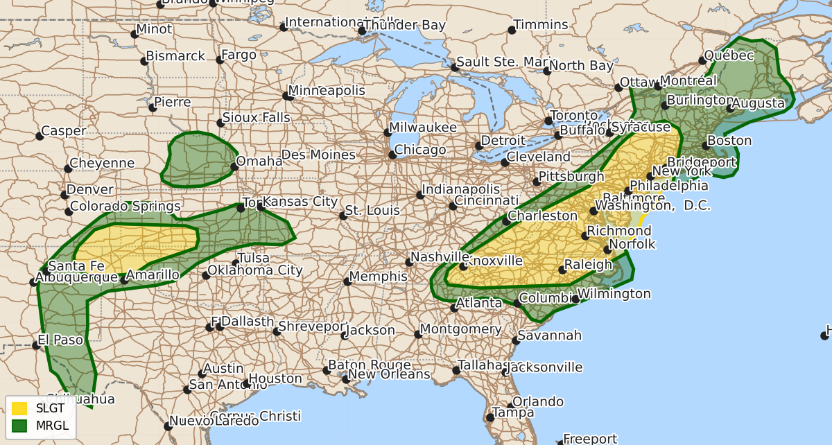
Summary
Severe thunderstorms capable of producing damaging winds are expected across parts of the Appalachians, Mid-Atlantic, and Northeast this afternoon and evening. Meanwhile, severe storms with threats of large hail and strong wind gusts are possible across parts of the southern High Plains through early tonight.
Product Text
000 ACUS01 KWNS 121958 SWODY1 SPC AC 121956 Day 1 Convective Outlook NWS Storm Prediction Center Norman OK 0256 PM CDT Fri Jun 12 2026 Valid 122000Z - 131200Z ...THERE IS A SLIGHT RISK OF SEVERE THUNDERSTORMS ACROSS PARTS OF THE NORTHEAST...MID-ATLANTIC...AND SOUTHERN APPALACHIANS AS WELL AS PARTS OF THE SOUTHERN HIGH PLAINS... ...SUMMARY... Strong to severe storms capable of damaging winds are expected across parts of the Appalachians, Mid-Atlantic, and Northeast, mainly this afternoon and evening. Severe storms with a threat of large hail and severe wind gusts will also be possible across parts of the south-central High Plains. ...20z Update... The previous forecast remains on track with minimal changes required to the existing probability lines based on ongoing convective trends and recent model guidance. The primary outlook amendment was the introduction of 5% hail probabilities across portions of eastern Nebraska. ...Nebraska... 12z ensemble guidance hinted at thunderstorm development across eastern NE during the 09-12 UTC period as a weak low-level cold front impinges on a plume of northward returning moisture. More recent runs of the RAP/RRFS/HRRR continue to show this potential and depict a fairly robust thermodynamic environment featuring MUCAPE values upwards of 4000 J/kg. 18 UTC RAOBS from the southern High Plains and Rockies sampled steep mid-level lapse rates that will advect eastward over the next 18 hours, and recent model solutions appear to be capturing surface moisture return well. These trends lend sufficient confidence to introduce a targeted hail risk area. ...Mississippi/Alabama... 5% wind probabilities were removed across northern MS/AL based on recent radar trends, which depict the outflow boundary of a decaying MCS rapidly progressing south and undercutting developing convection. Strong buoyancy immediately downstream may support some localized damaging wind threat through the afternoon, but latest model guidance largely shows diminishing convective activity as the outflow surges south. ..Moore.. 06/12/2026 .PREV DISCUSSION... /ISSUED 1130 AM CDT Fri Jun 12 2026/ ...Mid-Atlantic into New England this afternoon/evening... Within the northern stream, a shortwave trough will progress east-northeastward over the lower Great Lakes this afternoon/evening, while an associated surface cold front moves eastward into New England and southeastward into the Mid-Atlantic. Forcing for ascent will not be particularly strong and the stronger midlevel flow/deep-layer vertical shear will remain displaced to the cool side of the front. Still, 25-30 kt midlevel flow will overlap the warm sector this afternoon from northern Chesapeake Bay northward into eastern NY. Strong surface heating is ongoing from the Piedmont into VA/southern PA, with a few more cloud patches from northeast PA into central NY. The net result will be moderate buoyancy (MLCAPE of 1000-2000 J/kg) in an environment with steep low-level lapse rates and weak upper flow, favoring multicell clusters with occasional wind damage. The weak forcing for ascent suggests that widely scattered, loosely organized clusters will be possible this afternoon, with some gaps in the wind threat. ...Southern High Plains late this afternoon into early tonight... Lee cyclogenesis across southeast CO will draw low-level moisture northwestward into the southern High Plains as a stalled front begins to lift northward across the TX Panhandle. Thunderstorm development is expected this afternoon/evening with upslope flow into the higher terrain of NM, and along the Raton Mesa. Deep-layer vertical shear/hodograph length will be sufficient for supercells initially off Raton Mesa, with large hail the primary threat. Some upscale growth and an increase in the potential for severe outflow gusts is expected late this evening as storms spread eastward toward southwest KS and the northern Panhandles in association with a nocturnal low-level jet and strengthened warm advection/moisture transport. ...Eastern KS/western MO early Saturday... In response to low-level warm advection and returning moisture, elevated convection is probable late in the period across eastern KS/western MO. This area will be near the east edge of the steep midlevel lapse rates, where isolated large hail will be possible. There will also be some potential for evolution into a cluster or two with isolated damaging gusts. Farther north into eastern NE (very near the end of the period) there will be a chance for elevated storms with some hail. This area will be re-evaluated this afternoon in the 20z update. $$