Day 1 Convective Outlook
Issued: · Valid: –
Summary
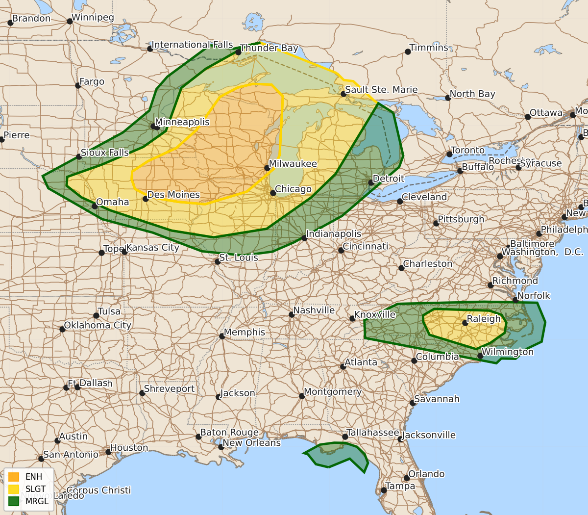
Severe thunderstorms capable of producing strong tornadoes, large hail, and damaging winds are expected across portions of the Upper Midwest and Great Lakes from this afternoon through tonight. Isolated damaging wind gusts are also possible across central North Carolina through the early evening.
Product Text
000 ACUS01 KWNS 201959 SWODY1 SPC AC 201957 Day 1 Convective Outlook NWS Storm Prediction Center Norman OK 0257 PM CDT Mon Jul 20 2026 Valid 202000Z - 211200Z ...THERE IS AN ENHANCED RISK OF SEVERE THUNDERSTORMS ACROSS PORTIONS OF THE UPPER MIDWEST... ...THERE IS A SLIGHT RISK OF SEVERE THUNDERSTORMS ACROSS CENTRAL NORTH CAROLINA... ...SUMMARY... Severe thunderstorms are expected across portions of the Upper Midwest and Great Lakes vicinity, especially late this afternoon into late evening. A few strong-intense tornadoes, swaths of damaging winds, and isolated very large hail will all be possible. Isolated damaging gusts may also occur over parts of North Carolina this afternoon. ...20z Update... The previous forecast largely remains on track with only minor adjustments made. Recent GOES imagery and surface observations show gradually building cumulus across eastern MN into northwest WI along a diffuse surface cold front. Latest high-res guidance suggests this will be the primary initiation zone over the next few hours, which increases confidence in the downstream severe threat and implies the severe threat is diminishing for areas further west. Risk probabilities were trimmed across northeast MN to reflect this trend. Elevated convection migrating across southeast MN/WI are indicative of steeper mid-level lapse rates (observed in upstream 18 UTC soundings) spreading east in the wake of this morning's weak MCS. This, coupled with steady warming/moistening of the low-level air mass and 50-60 knot mid-level flow observed by the KMPX and KDVN VWPs, lends confidence in the ongoing forecast for much of the region. See the previous discussion (below) and MCD #1674 for additional forecast details. ...North Carolina... Ongoing thunderstorms have exhibited pulse-like behavior over the past few hours across NC and adjacent areas. While much of this activity has been sub-severe, low-level thermodynamic conditions will remain favorable through early evening for strong to severe downburst winds. Given the ongoing coverage of convection across north-central NC, 15% risk probabilities were maintained. Elsewhere, more isolated strong/severe winds appear possible across northeast ND/northwest MN as a pocket of colder mid-level temperatures coincident with 30-40 knot low-level winds overspreads the region in tandem with the primary mid/upper-level trough. Similarly, very sporadic severe gusts associated with downbursts within a deeply-mixed environment are possible across central/southern AZ, as well as northern FL/far southern GA where local velocity data shows embedded swaths of strong winds associated with the outer convective bands of Tropical Depression 2. However, all of these regions, the kinematic/thermodynamic environments appear fairly marginal and/or convective signals in recent ensemble guidance are too weak to warrant severe wind highlights. ..Moore.. 07/20/2026 .PREV DISCUSSION... /ISSUED 1130 AM CDT Mon Jul 20 2026/ ...Upper Midwest through tonight... A midlevel shortwave trough is cresting the ridge and will turn southeastward today while moving over the upper MS Valley, as an associated cold front likewise moves southeastward into Upper MI, WI and IA. Earlier storms in Upper MI have weakened, while a cluster is ongoing in eastern IA. Destabilization will occur in the wake of the eastern IA storms as a reservoir of low-mid 70s boundary-layer dewpoints spreads northeastward from IA/southern MN into WI and western Upper MI. The low-level moistening will occur beneath a plume of midlevel lapse rates greater than 8 C/km and in tandem with surface heating in cloud breaks, all of which will drive MLCAPE in excess of 3000 J/kg. As is typical with lingering morning convection, there is some uncertainty regarding the specific locations of afternoon storm development in its wake. Wind profiles will favor supercells as the initial storm mode this afternoon along and just ahead of the cold front, given very long hodographs oriented largely orthogonal to the front. Low-level shear/hodograph curvature will also be substantial, which combined with the moist boundary layer, steep lapse rates and large buoyancy will support the potential for a few strong-intense tornadoes. Very large hail will be possible with the more discrete supercells, while significant severe outflow gusts will be possible with any clustering of storms later this afternoon/evening. Initial supercells will likely evolve into a cluster or two by early tonight while spreading southeastward across eastern IA, northern IL, northwest IN and Lower MI with a continued threat for occasional wind damage and isolated large hail. ...Central NC area this afternoon/evening... Thunderstorm development is expected again this afternoon along a stalled front/differential heating zone across NC, to the west of the more persistent cloud cover in far eastern NC. NC remains near the south edge of the midlevel westerlies, with mid 70s boundary-layer dewpoints coincident with temperatures at or above 90 F contributing to MLCAPE in excess of 2000 J/kg. A few damaging downbursts will be possible with precipitation-loaded downdrafts in an environment with steepening low-level lapse rates. ...FL Big Bend today... Tropical Depression #2 is forecast to drift slowly westward across the northeast Gulf through tomorrow and become a tropical storm. Though deep-layer wind profiles are not particularly favorable in the northeast quadrant of the cyclone, where winds aloft are from the northeast, there is just enough low-level shear to support weakly rotating storms in the outer convective bands. An isolated tornado/waterspout or two may occur today in coastal areas of the FL Big Bend. $$