Day 2 Convective Outlook
Issued: · Valid: –
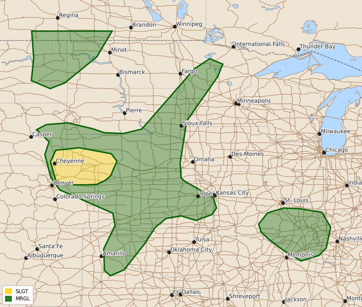
Summary
Severe thunderstorms capable of large hail, damaging winds, and brief tornadoes are possible Monday afternoon and evening across northeast Colorado, southeast Wyoming, and the Nebraska Panhandle. Isolated severe storms with large hail and damaging winds may also occur from the Canadian border through the Oklahoma and Texas Panhandles, while sporadic damaging winds are possible from the Ozark Plateau into the Mid-south.
Product Text
000 ACUS02 KWNS 071734 SWODY2 SPC AC 071732 Day 2 Convective Outlook NWS Storm Prediction Center Norman OK 1232 PM CDT Sun Jun 07 2026 Valid 081200Z - 091200Z ...THERE IS A SLIGHT RISK OF SEVERE THUNDERSTORMS OVER THE CENTRAL HIGH PLAINS... ...SUMMARY... Scattered severe storms capable of large hail and perhaps a brief tornado and damaging gusts are possible Monday afternoon and evening in northeast Colorado, southeast Wyoming, and into the Nebraska Panhandle. Additional, more isolated occurrences of large hail and damaging winds will be possible from the Canadian border into the Oklahoma and Texas Panhandles. Sporadic damaging winds may occur from the Ozark Plateau into the Mid-south. ...Synopsis... An upper low will pivot northward across central Canada with temporary height rises over the Plains. Moderate southwest flow aloft will persist from the central Rockies into the northern Plains during the day as an area of high pressure modifies there. To the south, low pressure will develop from the central to southern High Plains, with surface winds veering to easterly over KS/NE and into eastern CO and WY late. Ample moisture will exist with the zone of backed easterly flow, and this moist/unstable air mass will accelerate westward during the evening as 850 winds increase ahead of a secondary wave moving into the Rockies overnight. A weak surface trough will also remain over the mid MO Valley, just east of the western Dakotas surface high. Elsewhere, a weak midlevel wave will persist into the middle MS and lower OH Valleys, providing a focus for thunderstorms within the moist air mass. ...Central Plains... An area of moderate instability will develop across the central Plains as strong heating occurs and low-level winds increase out of the east. Storms are most likely to develop near the higher terrain from eastern WY into eastern CO, and on the interface of the steeper low-level lapse rates and moistening/upslope air mass. Favorable effective shear near 50 kt and steep lapse rates will clearly favor supercells initially with large damaging hail, with areas of wind-driven hail as storms evolve eastward through early evening. Low-level winds veering height may also support a brief tornado or two. The most concentrated area of severe storms will be from northeast CO into western NE, but sporadic cells may occur as far north as the Black Hills area. Finally, a few cells may develop within the hot inverted-v environment into the TX Panhandle/western OK during the afternoon with locally damaging gusts. ..Far Northern Plains... Late Monday night into Tuesday morning, warm/moist advection will accelerate ahead of the developing trough over the Rockies. Models are a bit uncertain, but potential will exist for elevated storms with hail potential over eastern MT into northwest MN as lift and instability increase. ...Southeast MO into western TN... A slow-moving midlevel trough should again provide a focus for storm development, as deep moisture is maintained and areas of heating occur. New development is most likely to occur with any existing MCV, or near differential heating zones. Locally strong low-level shear is anticipated which may aid brief/weak tornado potential. ..Jewell.. 06/07/2026 $$